White ash over Edo, December 16, 1707: Mount Fuji's last eruption
.jpg)
TL;DR — Mount Fuji last erupted from December 16, 1707, to January 1, 1708, burying Subashiri and dropping ash on Edo; a national levy and river floods followed.
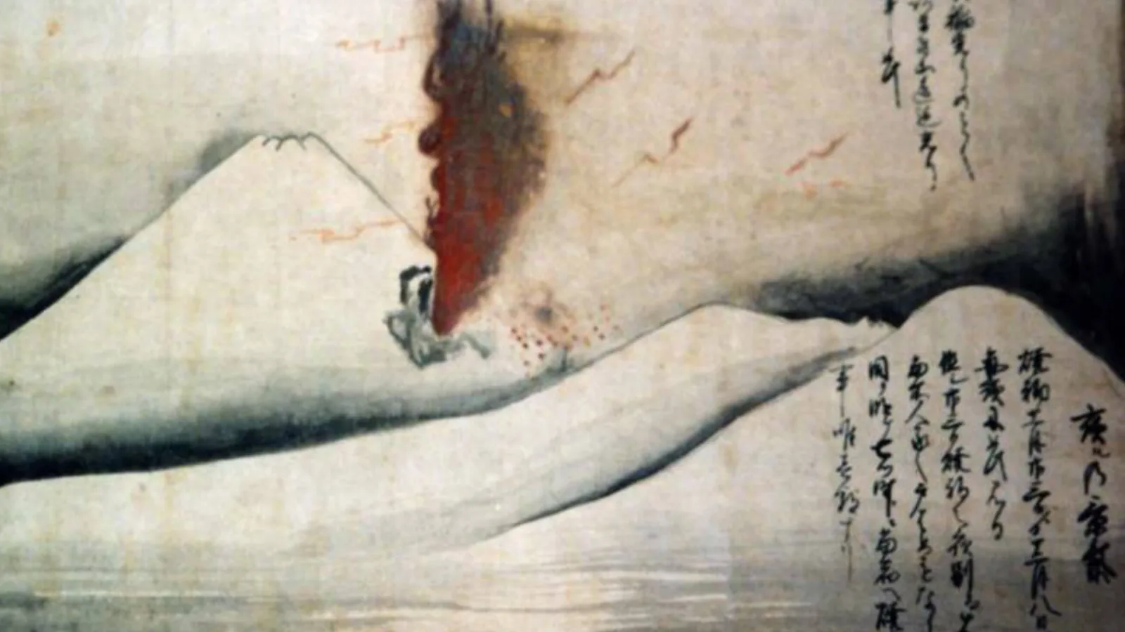
Mount Fuji began its most recent eruption on December 16, 1707, from a new vent on its southeast flank, and kept erupting for 16 days. A 2006 report for Japan’s Cabinet Office gives the dates as 「宝永4年11月23日(1707年12月16日)~宝永4年12月9日(1708年1月1日)」 (from the 23rd day of the 11th month of Hōei 4 to the ninth day of the 12th month). East of the mountain, Subashiri, about 10 kilometers from the vent, lost half its houses to fire. Ash reached Edo, now Tokyo, on the first day. The same report records that in 1708 the shogunate levied gold from every province and that the Sakawa River, its bed raised by ash, broke its embankment that summer.
Quick facts
- When
- October 28, 1707 (the Hōei earthquake) · December 16, 1707, about 10 a.m. (eruption begins) · January 1, 1708 (eruption ends) · intercalary first month of Hōei 5, 1708 (land exchange and national levy) · 22nd day of the sixth month of Hōei 5, 1708 (Ōguchi embankment on the Sakawa River breaks) · February 2006 (Central Disaster Management Council basic policy) · March 2006 (Cabinet Office report)
- Where
- The southeast flank of Mount Fuji (the Hōei craters); Subashiri and the villages east of the mountain; Edo, now Tokyo; the Sakawa River in Sagami province, now Kanagawa Prefecture
- Who
- Tsuchiya Itayū of Suyama village; the bannerman Itō Sukekata; Arai Hakuseki; Yabuta Gorōemon Shigemori; Ōkubo Tadamasu, lord of Odawara; Ogiwara Shigehide; the intendant Ina Hanzaemon Tadanobu
- Outcome
- A 16-day eruption from three new craters buried the villages east of Fuji and dropped ash on Edo. The shogunate took over the Odawara domain's damaged lands, raised a national levy of which only part can be traced to relief, and in 1708 the ash-choked Sakawa River broke its embankment
December 16, 1707: three craters on the southeast flank
The eruption came 49 days after a great earthquake. On October 28, 1707, a fault running under the sea from off Shikoku to Suruga Bay broke. The Geological Survey of Japan (GSJ), in its eruption database, gives that earthquake a moment magnitude of 8.7; GSJ’s commentary to its geological map of Fuji gives it as M 8.4. The Cabinet Office report writes that the eruption began 「この宝永東海地震の発生から49日目」 (on the 49th day after the Hōei Tōkai earthquake). Shizuoka University counts 48 days from the earthquake to the afternoon of December 15, when a full swarm of tremors began around the mountain.
GSJ puts the start at about 10 a.m. on December 16. The first blast threw out pale dacite pumice in a column that reached 15 kilometers, and by about 4 p.m. the vent was throwing black scoria. Shizuoka University describes three craters in a line down the southeast flank: pumice came first from the second and third, and then the first and largest crater threw scoria for about half a month. The Japan Meteorological Agency (JMA) puts the magma erupted at 0.7 cubic kilometers, dense-rock equivalent, and rates the eruption VEI 5 on the volcanic explosivity index. GSJ’s map commentary records that it ended before dawn on January 1, 1708.
Subashiri and the villages east of the mountain
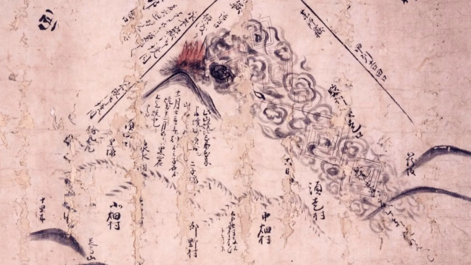
On the night of December 16, GSJ records, blocks more than 10 centimeters across fell on Subashiri and half of its houses burned. The Cabinet Office summary sheet adds 「須走村75戸倒壊。」 (75 houses in Subashiri village collapsed), and Shizuoka University gives the depth of lapilli and ash there as up to 2 meters. The report measures a steep fall-off with distance: 300 centimeters at Oyama, 10 kilometers from the vent; 30 centimeters at Isehara, 50 kilometers away; 8 centimeters at Ichihara in Chiba, 120 kilometers off. JMA gives 5 centimeters at Kawasaki.
Tsuchiya Itayū of Suyama village, on the mountain’s southeast foot, wrote of fire-stones the size of tea kettles or large tea bowls that split open and set thatch alight, and ended 「家など一村にて五軒三軒ずつ焼け申し候」 (in each village houses burned, five or three at a time). The Cabinet Office report doubts its own witness here: Suyama lay near the southern edge of the ashfall, and the burning he described was probably news carried from Subashiri and other villages nearby.
No count of the dead exists in these sources. The summary sheet states that no direct deaths were recorded. JMA’s table of Fuji’s historical activity adds that in villages where houses and farmland were buried, 「餓死者多数」 (many starved).

"White ash" in the streets of Edo
Edo lay about 100 kilometers northeast of the vent. Arai Hakuseki, whom Shizuoka University names among the shogunate’s leading men, wrote in his memoir Oritaku shiba no ki that the ground had shaken the night before and that thunder sounded in the afternoon. Going out, he saw what looked like falling snow: 「白灰の下れる也」 (it was white ash coming down). By the time he reached the western citadel of the castle, 「白灰地を埋みて、草木もまた皆白くなりぬ」 (white ash covered the ground, and the grass and trees had all turned white).
The Cabinet Office report leans on another witness, the far more detailed diary of the bannerman Itō Sukekata. In the late morning of the first day he saw blue-black clouds rise like mountains to the southwest, and though the ground did not shake, 「家震へ、戸・障子強く鳴り申し候。風少しも吹き申さず候」 (the house shook and the doors and paper screens rattled hard; there was no wind at all). The report reads this as the air wave of explosions felt 100 kilometers away. That night he wrote 「夜に入り候へて降り候砂の色黒く、常の川砂なり。」 (after dark the falling sand turned black, like ordinary river sand), with a few millimeters settled over the day.
Some of that first fall survives. Yabuta Gorōemon Shigemori, a senior retainer of the Kōfu domain, collected ash at its Edo residence outside the Kandabashi gate. The report records that it was found in 1996 in the storehouse of a related family in Yamatokōriyama, and that a Hokkaido University group under Ui Tadahide confirmed it as the pumice ash of the first day, fine as wheat flour.
Money, land and the Sakawa River, 1708
The Cabinet Office’s 2006 report records that on the third day of the intercalary first month of Hōei 5 (1708) the shogunate announced it would exchange private lands in Musashi, Sagami and Suruga too damaged to govern. The Odawara domain under Ōkubo Tadamasu gave up more than 56,384 koku of lands, according to the report, and received villages in four other provinces in their place.
Four days later, the report records, came the national levy, the shokoku takayakukin. The decree it quotes set 「高百石につき金二両」 (two ryō of gold for every 100 koku of assessed yield) with temple and shrine lands exempt. The report gives the total paid into the shogunate’s treasury during 1708 as more than 488,770 ryō of gold, about 40 percent of its annual revenue, and the part that can be traced to relief as a little over 62,500 ryō. It cites Hakuseki’s memoir for the finance official Ogiwara Shigehide’s account: 160,000 ryō for recovery and 240,000 kept for building a palace in the Kitanomaru enclosure of Edo Castle. The report’s own reading of the levy is 「窮余の財政補填策」 (a last-resort patch for the shogunate’s finances).
The report records that Ina Hanzaemon Tadanobu, the shogunate’s intendant at the Sakawa office, is remembered in the Mikuriya district as a benefactor and was later honored as a god, with shrines raised in 1867 and 1878; it also states that contemporary records of him are 「至って乏しく」 (very scarce).
On the ninth day of the intercalary first month, according to the report, the Okayama domain and four others were ordered to dredge the ash-filled Sakawa River at their own cost. The report records that just after that work ended, heavy rain on the 22nd day of the sixth month of Hōei 5 broke the Ōguchi embankment, and six villages below it were buried under 1.5 to 3.0 meters of sediment. By its account the five lords received seasonal robes from the shogun at Edo Castle on the 28th, six days after the break.
In February 2006 the Central Disaster Management Council opened its basic policy for a future eruption with the line 「富士山は、1707年(宝永四年)に噴火した後、約三百年間沈黙を守っている。」 (Mount Fuji, after erupting in 1707, has kept silent for about three hundred years).
Key facts
- The eruption ran from December 16, 1707, to January 1, 1708, from three new craters on Fuji’s southeast flank (Cabinet Office summary sheet; Shizuoka University).
- It began about 10 a.m. on December 16, with a column that reached 15 kilometers (GSJ).
- The Hōei earthquake of October 28, 1707, came 49 days before by the Cabinet Office and GSJ; Shizuoka University counts 48 days to the swarm of December 15. GSJ gives Mw 8.7 in one page and M 8.4 in another.
- At Subashiri, half the houses burned (GSJ) and 75 collapsed (Cabinet Office); JMA records 5 centimeters of ash at Kawasaki.
- The Cabinet Office report records a levy of two ryō per 100 koku in 1708 that raised more than 488,770 ryō, of which a little over 62,500 ryō can be traced to relief.
- The report records the Ōguchi embankment on the Sakawa River broke on the 22nd day of the sixth month of 1708, burying six villages.
FAQ
When did Mount Fuji last erupt?
From December 16, 1707, to January 1, 1708, in the Hōei eruption. The Central Disaster Management Council wrote in February 2006 that the mountain had kept silent for about 300 years since.
How many people died in the 1707 Fuji eruption?
No count exists in the Japanese government and university sources cited below. The Cabinet Office summary sheet records no direct deaths, and JMA records that many starved in villages where houses and farmland were buried.
Did ash from the Hōei eruption reach Edo?
Yes. Arai Hakuseki and the bannerman Itō Sukekata both described ash falling on Edo on the first day, and a sample collected in the city that day was found in 1996 and analyzed by a Hokkaido University group.
Sources
- Cabinet Office (Japan), Central Disaster Management Council, Expert Panel on the Transmission of Disaster Lessons, report "1707 富士山宝永噴火": disaster summary sheet, p. 186 (dates, affected area, 75 houses collapsed at Subashiri, no direct casualties recorded).
- Cabinet Office, report "1707 富士山宝永噴火", index page (report dated March 2006, 平成18年3月).
- Cabinet Office, report "1707 富士山宝永噴火", chapter 2, "宝永噴火の推移と噴出物" (the Hōei earthquake and the 49-day interval, the Suyama and Edo eyewitness texts, ash thickness, the Edo ash sample found in 1996).
- Cabinet Office, report "1707 富士山宝永噴火", chapter 4, "一次災害への国家的対応と社会的影響" (the Odawara land exchange, the national levy and its spending, Ina Tadanobu, the Sakawa River works and the Ōguchi embankment break).
- Central Disaster Management Council, "富士山火山広域防災対策基本方針" (Basic Policy on Wide-Area Disaster Countermeasures for Mount Fuji Volcano), February 2006.
- Japan Meteorological Agency, "富士山 有史以降の火山活動" (volcanic activity of Mount Fuji in the historical period).
- Geological Survey of Japan, AIST, Eruption Sequence Database, "富士山 宝永噴火" (Fuji 1707 eruption).
- Geological Survey of Japan, AIST, Fuji volcano geological map commentary, "富士-1: はじめに".
- Shizuoka University, Center for Integrated Research and Education of Natural Hazards, "活火山富士山がわかる本", south course 1, "宝永火口".
- Shizuoka University, Center for Integrated Research and Education of Natural Hazards, "活火山富士山がわかる本", section 3, "貞観噴火と宝永噴火".
Cite this article
- APA
- LETTER. (2026, September 29). White ash over Edo, December 16, 1707: Mount Fuji's last eruption. Our Earth's History. https://ourearthshistory.com/east-asia/early-modern/hoei-eruption-mount-fuji-december-16-1707-ash-on-edo/
- Chicago
- LETTER. “White ash over Edo, December 16, 1707: Mount Fuji's last eruption.” Our Earth's History, September 29, 2026. https://ourearthshistory.com/east-asia/early-modern/hoei-eruption-mount-fuji-december-16-1707-ash-on-edo/.
- MLA
- LETTER. “White ash over Edo, December 16, 1707: Mount Fuji's last eruption.” Our Earth's History, 29 Sep. 2026, https://ourearthshistory.com/east-asia/early-modern/hoei-eruption-mount-fuji-december-16-1707-ash-on-edo/.
Text licensed CC BY-NC-ND 4.0. Found an error? Tell us.