January 17, 1995: Japan's official Hanshin-Awaji count, 6,434 dead

TL;DR — Japan rated the January 17, 1995 quake M7.2, then M7.3 in 2001. Deaths stood at 6,308 that December; the 2006 final count is 6,434.
At 5:46 a.m. on January 17, 1995, an earthquake originating under the northern part of Awaji Island shook Hyogo Prefecture. Japan’s Cabinet Office gives the epicenter as 34 degrees 36 minutes north, 135 degrees 2 minutes east, at a depth of 16 kilometers, and rates the shock at magnitude 7.3. That magnitude carries a footnote: the number announced on the day was 7.2, and the Japan Meteorological Agency’s own Magnitude Review Committee raised it to 7.3 on April 23, 2001. The US Geological Survey, working independently from Harvard’s centroid moment tensor catalogue, lists a moment magnitude of 6.9 for the same event, with a depth of 21.9 kilometers and an epicenter 8 kilometers south of Akashi. Deaths from the quake were later fixed at 6,434, a figure that itself grew over eleven years from an earlier tally.
Quick facts
- When
- January 17, 1995, 5:46 a.m. Japan Standard Time
- Where
- Northern Awaji Island, Hyogo Prefecture (USGS places the epicenter 8 kilometers south of Akashi)
- Who
- Japan Meteorological Agency; Japan's Cabinet Office; Japan's Fire and Disaster Management Agency; US Geological Survey
- Outcome
- 6,308 dead and 2 missing by December 27, 1995; 6,434 dead, 3 missing and 43,792 injured in the Fire and Disaster Management Agency's final report of May 19, 2006
January 17, 1995: an intensity of 6, then a 7 found on the ground
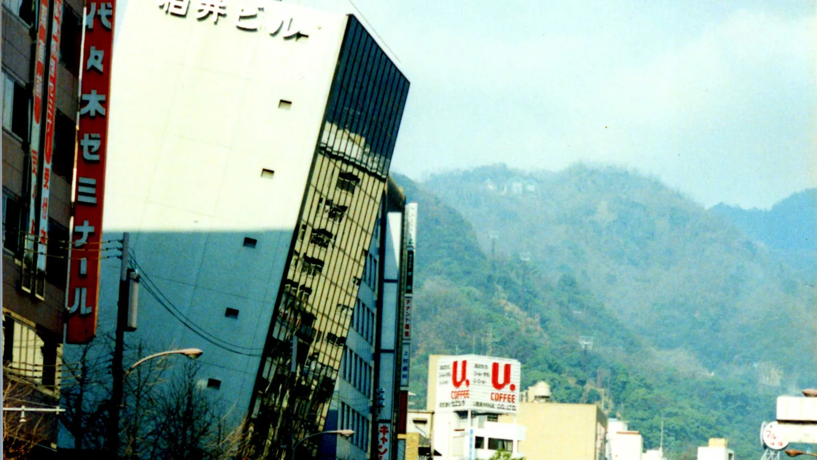
The Japan Meteorological Agency recorded seismic intensity 6 (shindo 6, on the agency’s own scale) at Kobe and Sumoto, intensity 5 at Toyooka, Hikone and Kyoto, and intensity 4 at Osaka, Himeji and Wakayama, with the shaking felt from Tohoku to Kyushu. The Cabinet Office’s account adds that the agency’s own mobile survey team, working in the field immediately after the quake, found that parts of Kobe had in fact experienced intensity 7, the top of the scale. The Cabinet Office’s chronology dates the formal result to January 20, 1995: the first time intensity 7 was assigned to a Japanese earthquake through a field survey rather than an instrument reading. The zone the survey marked at that level ran through six wards of Kobe, the areas near Ashiya Station and Shukugawa in Nishinomiya, part of Takarazuka, and parts of Hokudan, Ichinomiya and Tsuna on northeastern Awaji Island.
Kobe Marine Observatory recorded 818 gal, north-south
The Cabinet Office’s overview lists peak ground acceleration by station. Kobe Marine Observatory, in Chuo ward, recorded 818 gal north-south, 617 gal east-west and 332 gal vertical, compared with the same three readings at Osaka (81, 66, 65 gal), Maizuru (67, 52, 39), Okayama (77, 59, 36), Tottori (77, 74, 15), Hikone (137, 147, 39), Tsu (71, 60, 26) and Fukui (33, 42, 10). The Cabinet Office calls the event an inland, shallow-focus earthquake, and states that a new fault scarp was confirmed on northern Awaji Island, with fresh slip on the Nojima Fault.

Two official names, decided on two different dates
The Japan Meteorological Agency named the earthquake itself the “1995 Southern Hyogo Prefecture Earthquake” at 11:00 a.m. on the day it struck, according to the Cabinet Office’s chronology. The disaster that followed received a separate name through a separate process: the government’s cabinet gave oral agreement on February 14, 1995, that the disaster would be called the “Great Hanshin-Awaji Earthquake” (Hanshin-Awaji Daishinsai).
6,434 dead, 3 missing, 43,792 injured, by the 2006 final report
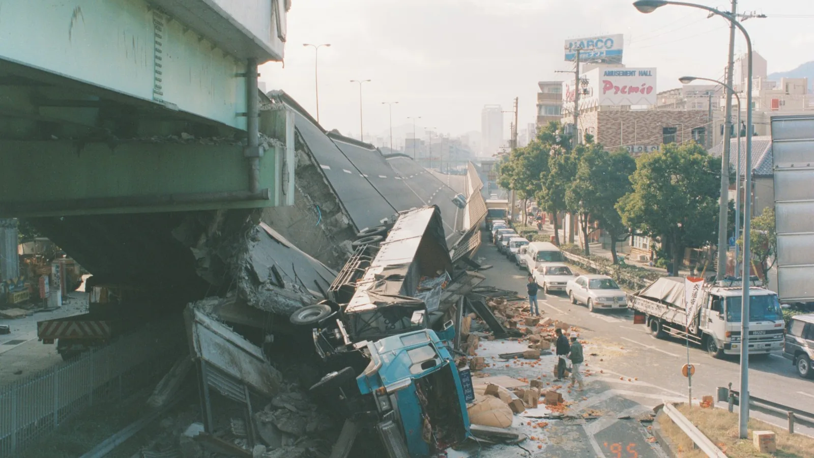
The Fire and Disaster Management Agency’s final report, dated May 19, 2006 and current as of December 22, 2005, gives human losses as 6,434 dead, 3 missing and 43,792 injured, of whom 10,683 were listed as seriously hurt and 33,109 as lightly hurt. The Cabinet Office’s chronology carries an earlier tally: on December 27, 1995, roughly eleven months after the quake, deaths recognized through additional disaster certification stood at 6,308, with 2 people missing. Among the deaths, the Cabinet Office’s overview records a landslide at Nigawa-Yurinocho in Nishinomiya that killed 34 people. Housing losses reached 104,906 buildings completely destroyed, 144,274 half destroyed and 390,506 partly damaged, for a total of 639,686 damaged homes. Public infrastructure losses included 1,875 school and education buildings, 7,245 roads, 330 bridges, 774 rivers, 347 slope failures and 2,468 block walls, the Cabinet Office’s tables record. Transportation was cut immediately: 13 railway companies had disrupted lines, including the collapse of elevated Sanyo Shinkansen track, and 36 sections across 27 expressway and national highway routes were closed to traffic. At the peak, about 1.3 million households lost water, about 860,000 lost city gas within the Osaka Gas area, about 2.6 million lost electricity, and more than 300,000 telephone lines were out, the Cabinet Office’s tables state. Damage to farming, forestry and fisheries came to about 90 billion yen, the same overview states.
April 1995: the Shinkansen and the water lines came back
Japan’s Self-Defense Forces finished clearing collapsed buildings on April 16, 1995, and completed their withdrawal on April 27, the hundredth day after the quake, the Cabinet Office’s chronology records. The Tokaido and Sanyo Shinkansen resumed full service between Shin-Osaka and Himeji on April 8, eighty-one days after the line was cut by the collapse of elevated track. Water service reached all of Kobe’s roughly 650,000 households on April 17. Hyogo Prefecture finished 48,300 emergency temporary housing units on August 11, and Kobe closed its last evacuation shelters on August 20, when 6,672 people remained across 196 sites. Kobe’s own population, which had fallen by about 97,000 in the October 1, 1995 national census compared with January 1 of that year, passed its pre-quake level again on November 1, 2004.
Key facts
- The quake struck at 5:46 a.m. on January 17, 1995, under northern Awaji Island, at a depth the Cabinet Office gives as 16 kilometers; USGS gives 21.9 kilometers.
- The Japan Meteorological Agency’s magnitude was announced as 7.2 on the day and revised to 7.3 by the agency’s Magnitude Review Committee on April 23, 2001.
- USGS lists an independent moment magnitude of 6.9 for the same event, citing the Harvard centroid moment tensor catalogue.
- Seismic intensity 6 was recorded at Kobe and Sumoto; a Japan Meteorological Agency field survey found intensity 7 in parts of Kobe, confirmed January 20, 1995.
- Kobe Marine Observatory recorded a peak ground acceleration of 818 gal, north-south.
- The Fire and Disaster Management Agency’s final report (May 19, 2006) counts 6,434 dead, 3 missing and 43,792 injured; a December 27, 1995 tally had counted 6,308 dead and 2 missing.
- Housing damage totaled 639,686 buildings: 104,906 completely destroyed, 144,274 half destroyed and 390,506 partly damaged.
- The Tokaido and Sanyo Shinkansen resumed full service between Shin-Osaka and Himeji on April 8, 1995, eighty-one days after the quake.
FAQ
What magnitude was the Hanshin-Awaji earthquake?
The Japan Meteorological Agency announced magnitude 7.2 on January 17, 1995, and revised it to 7.3 on April 23, 2001, after review by its own Magnitude Review Committee. The US Geological Survey separately lists a moment magnitude of 6.9 for the same earthquake.
How many people died in the Hanshin-Awaji earthquake?
Japan's Fire and Disaster Management Agency's final report, dated May 19, 2006 and current as of December 22, 2005, counts 6,434 dead, 3 missing and 43,792 injured. An earlier Cabinet Office chronology entry for December 27, 1995 had recorded 6,308 dead and 2 missing.
Why does the earthquake have two names?
The Japan Meteorological Agency named the earthquake itself the 1995 Southern Hyogo Prefecture Earthquake on the day it struck. Japan's cabinet separately agreed, on February 14, 1995, to call the disaster the Great Hanshin-Awaji Earthquake, a name for the disaster rather than the seismic event.
Sources
- Cabinet Office, Government of Japan, disaster management pages, "Overview of the Great Hanshin-Awaji Earthquake" (阪神・淡路大震災の概要), citing the Fire and Disaster Management Agency's final report of May 19, 2006.
- Cabinet Office, Government of Japan, disaster management pages, "Chronology of Major Developments After the Earthquake" (震災後の主な動き).
- Cabinet Office, Government of Japan, disaster management pages, "Overview of the Lessons and Information Collection" (阪神・淡路大震災教訓情報資料集の概要).
- US Geological Survey, event page usp0006rew, FDSN event web service.
Cite this article
- APA
- LETTER. (2026, September 28). January 17, 1995: Japan's official Hanshin-Awaji count, 6,434 dead. Our Earth's History. https://ourearthshistory.com/east-asia/contemporary/hanshin-awaji-earthquake-january-17-1995-official-count-6434-magnitude/
- Chicago
- LETTER. “January 17, 1995: Japan's official Hanshin-Awaji count, 6,434 dead.” Our Earth's History, September 28, 2026. https://ourearthshistory.com/east-asia/contemporary/hanshin-awaji-earthquake-january-17-1995-official-count-6434-magnitude/.
- MLA
- LETTER. “January 17, 1995: Japan's official Hanshin-Awaji count, 6,434 dead.” Our Earth's History, 28 Sep. 2026, https://ourearthshistory.com/east-asia/contemporary/hanshin-awaji-earthquake-january-17-1995-official-count-6434-magnitude/.
Text licensed CC BY-NC-ND 4.0. Found an error? Tell us.