Australia del Espiritu Santo: Quiros at a bay in Vanuatu, 1606
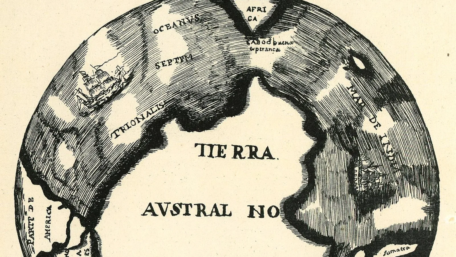

TL;DR — Quiros’s fleet entered a Vanuatu bay on May 1, 1606, and he named the land Australia del Espiritu Santo; in June his ship and Torres’s parted.
“It was the day of St. Thomas the Apostle, Wednesday, at three in the afternoon, the 21st of December, 1605,” Pedro Fernandez de Quiros wrote of the day his three ships left the port of Callao. The flagship was the San Pedro y San Pablo, the second ship “rather small” in his own words, and the third a launch, a zabra, newly returned from the Galapagos. Luis Vaez de Torres sailed as his almirante, second-in-command, and nearly 300 men crewed the three vessels. Torres’s own letter to the Spanish king, written from Manila in 1607, gives the identical date independently: “We sailed from Callao, of the city of the Kings of Peru, on December the 21st, 1605, with two ships and a launch.”
Quick facts
- When
- December 21, 1605 (departure from Callao) · May 1, 1606 (the bay entered) · May 3 (three ships anchored) · June 8 and June 11 (the ships separated, dates differ by source) · July 12, 1607 (Torres's letter written at Manila)
- Where
- Callao, Peru; a bay on the island of Espiritu Santo in what is now Vanuatu, called the Bay of St. Philip and St. James; New Guinea's south coast; Manila
- Who
- Pedro Fernandez de Quiros, captain-general; Luis Vaez de Torres, his almirante; nearly 300 men on three vessels
- Outcome
- Quiros named the bay's region Australia del Espiritu Santo and ordered a city, New Jerusalem, founded there. A storm in June 1606 separated his flagship from Torres's ship. Quiros sailed back across the Pacific to Acapulco; Torres opened the king's sealed orders and sailed on past New Guinea to Manila.
Callao to a bay in the New Hebrides
The fleet crossed the Pacific for more than four months before Quiros’s narrative records the approach: “at a distance of 6 leagues, on the 1st of May, we entered a great bay, where we passed the night.” Two days later, on May 3, he wrote, “the three vessels anchored in the port with great joy, giving many thanks to God.” The bay lay on the island now called Espiritu Santo, part of Vanuatu.
A possession ceremony and three new names
After a Mass, Quiros had a formal declaration read aloud in the name of the Spanish crown. Its text named three places at once: “I take possession of this bay, named the Bay of St. Philip and St. James, and of its port named Santa Cruz, and of the site on which is to be founded the city of New Jerusalem, in latitude 15° 10’, and of all . . . this region of the south as far as the Pole, which from this time shall be called Australia del Espiritu Santo.” Quiros also announced a new chivalric order that night, the “Knights of the Holy Ghost,” and gave each man present a blue cross.
The exact date of that ceremony is not settled. Cardinal Patrick Francis Moran’s compilation, “Discovery of Australia by de Quiros in the Year 1606,” gives two different days for it within the same book: its own narrative states that “Pentecost Sunday (10th May) was now at hand,” while a diary it separately quotes reads “14th May. Feasts of Pentecost. He gives the names of the municipality and officers appointed for the new city to be founded.” The Markham translation of Quiros’s own narrative supplies no numbered date, recording only that “by Friday, the eve of Pentecost, they finished all that had been arranged.”
The bay’s latitude is likewise given two ways. Quiros’s possession document places New Jerusalem at 15° 10’ south. Torres, writing separately, measured the same bay at “15¾° S. latitude, and in circuit it is 25 leagues,” a difference of 35 minutes from Quiros’s figure. Torres also recorded a possession ceremony of his own, separate from Quiros’s, made in the king’s name.
Before the Pentecost ceremony, Quiros’s narrative records, a soldier shot an islander without orders, and an islander leader was killed in fighting later the same day.
The ships part in a storm
By Quiros’s account, all three vessels tried to leave the bay on “Thursday, the 8th of June,” then struggled through the night against a headwind. His chief pilot told him “he was unable to reach the port,” and Quiros wrote that “during this and the two following days, attempts were made to enter the bay. The other vessels did not come out; the wind did not go down.” The flagship was driven out to sea.
Torres dated the final separation differently: “From within this bay, and from the most sheltered part of it, the Capitana departed at one hour past midnight, without any notice given to us, and without making any signal. This happened on the 11th of June.” Quiros’s account describes an attempted joint departure on June 8 and days of failed reentry; Torres’s letter fixes the moment the flagship left his sight, at midnight on June 11.
Torres opens the king's orders
Torres waited fifteen more days, then opened the king’s sealed orders after consulting the launch’s officers and decided to carry them out, noting that “my temper was different from that of Captain Pedro Fernandez de Quiros.” He complained the flagship had taken the expedition’s trade goods, “even to tools and medicines.”
Torres pushed south, one degree beyond his instructed limit, then turned northwest toward New Guinea, whose coast he described as running “W.b.N. and E.b.S.” He followed it for “300 leagues,” past “a bank of from 3 to 9 fathoms, which extends along the coast above 180 leagues,” a passage that later carried his name as the Torres Strait, though his letter does not use that word. He reported taking “twenty persons of different nations” as captives, then reached the Moluccas, where he met “Mahometans who were clothed, with artillery,” and Christians on the island of Bacan. The letter is dated “Manilla, July 12th, 1607,” and marked “received June 22nd, 1608.”
Quiros, for his part, recrossed the Pacific alone. His narrative places the ship back at the equator on July 2, then a shipboard council choosing Acapulco as a destination, Navidad reached on October 21 and finally “the port of Acapulco, on the 23rd of November, 1606.” An elderly chaplain died at sea on the return; two islander boys taken from Espiritu Santo, baptized Pedro and Pablo, received confirmation at Acapulco.
A 1617 petition to the crown
Quiros spent his later years petitioning the Spanish king for a new expedition. His printed appeal, published in London in 1617 as “Terra Australis Incognita; Or, A New Southern Discovery,” restated his claim: “the Countries which we have discover’d in 15 Degrees of Latitude, are better than Spain.”
Key facts
- Quiros’s three ships left Callao on December 21, 1605, a date his own narrative and Torres’s 1607 letter both give independently.
- The fleet entered the bay on May 1, 1606, and anchored on May 3, by Quiros’s account.
- The possession document named the bay St. Philip and St. James, the port Santa Cruz, the planned city New Jerusalem at 15° 10’ south, and the wider region Australia del Espiritu Santo.
- Moran’s compilation gives the Pentecost ceremony as May 10 in its own narrative and as May 14 in a diary it quotes; Quiros’s narrative gives no numbered date.
- Torres recorded the bay’s latitude as 15¾° south, 35 minutes from the possession document’s figure.
- Quiros’s account has the ships attempting to leave together on June 8; Torres’s letter fixes the flagship’s final disappearance at one hour past midnight on June 11.
- After opening the king’s sealed orders, Torres sailed south of New Guinea for roughly 300 leagues of coast before reaching the Moluccas and Manila.
- Quiros reached Acapulco on November 23, 1606, and later petitioned the crown in print in 1617, restating a claim to land “in 15 Degrees of Latitude.”
FAQ
What did Quiros name the bay in Vanuatu?
His possession document named the bay itself the Bay of St. Philip and St. James, its port Santa Cruz, a planned city New Jerusalem, and the surrounding region Australia del Espiritu Santo, all read aloud in a ceremony in May 1606.
Why did Quiros and Torres end up going separate ways?
A storm in June 1606 drove Quiros's flagship out of the bay while Torres's ship and the launch stayed behind. Quiros's account and Torres's letter give different dates for the moment of separation. Torres then opened the king's sealed orders and continued the voyage under his own command.
Did Torres name the Torres Strait himself?
His 1607 letter to the king describes sailing along New Guinea's south coast and past a shallow bank for roughly 300 leagues, but the letter itself does not use the word strait. The strait was named for him later.
Sources
- Pedro Fernandez de Quiros, tr. Sir Clements Markham, "The Voyages of Pedro Fernandez de Quiros, 1595 to 1606," Vol. I (Hakluyt Society, 1904), Project Gutenberg ebook #41200.
- Same work, Vol. II (Hakluyt Society, 1904), Internet Archive digitization of the Royal Asiatic Society Bombay Branch copy, containing the letter of Luis Vaez de Torres to the king of Spain, Manila, July 12, 1607.
- Pedro Fernandes de Queiros, "Terra Australis Incognita; Or, A New Southern Discovery, containing A Fifth Part of the World" (London, 1617), Project Gutenberg ebook #57269.
- Cardinal Patrick Francis Moran, "Discovery of Australia by de Quiros in the Year 1606," Project Gutenberg of Australia ebook 0600641h.
Cite this article
- APA
- LETTER. (2026, September 28). Australia del Espiritu Santo: Quiros at a bay in Vanuatu, 1606. Our Earth's History. https://ourearthshistory.com/oceania/early-modern/quiros-espiritu-santo-1606-australia-del-espiritu-santo-torres/
- Chicago
- LETTER. “Australia del Espiritu Santo: Quiros at a bay in Vanuatu, 1606.” Our Earth's History, September 28, 2026. https://ourearthshistory.com/oceania/early-modern/quiros-espiritu-santo-1606-australia-del-espiritu-santo-torres/.
- MLA
- LETTER. “Australia del Espiritu Santo: Quiros at a bay in Vanuatu, 1606.” Our Earth's History, 28 Sep. 2026, https://ourearthshistory.com/oceania/early-modern/quiros-espiritu-santo-1606-australia-del-espiritu-santo-torres/.
Text licensed CC BY-NC-ND 4.0. Found an error? Tell us.