Lake floor or dry land: the terraces Tarawera took on June 10, 1886

TL;DR — Tarawera erupted on June 10, 1886, burying Te Wairoa; the Pink and White Terraces vanished, and 2011 lake and 2023 land studies disagree on where they lie.
Around 1:20 a.m. on June 10, 1886, people at Te Wairoa, a village southeast of Rotorua in New Zealand, felt an earthquake and saw a cloud rising from Mount Tarawera. By about 6:30 a.m. a rift 17 kilometers long had opened across the mountain and through Lake Rotomahana, roughly a meter of mud and scoria lay on the village, and the Pink and White Terraces on the lake shore had vanished. The GNS Science fact sheet gives the dead as more than 100; an account from GNS Science and Science NZ, published by Universities New Zealand in 2024, gives 120. Archaeologists excavated part of Te Wairoa in 1990. The terraces are still argued over: a lake survey by GNS Science and the Woods Hole Oceanographic Institution reported remnants of the Pink Terraces under the water, and the independent researcher A. Rex Bunn placed the White Terraces on land in 2023.
Quick facts
- When
- June 10, 1886, from about 1:20 or 1:30 a.m. to about 6:30 a.m. · November 1989 and January 8 to February 2, 1990 (first professional archaeology at Te Wairoa) · 2011 (first reports from the lake survey) · March 28, 2023 (Bunn's paper) · May 28, 2024 (GNS Science account republished)
- Where
- Mount Tarawera and Lake Rotomahana, southeast of Rotorua, New Zealand; the village of Te Wairoa near Lake Tarawera
- Who
- the Tūhourangi people of Te Wairoa; about 15 European residents; GNS Science and the Woods Hole Oceanographic Institution; archaeologist Alexy Simmons; independent researcher A. Rex Bunn
- Outcome
- A 17 km rift opened across the mountain and through Lake Rotomahana; the dead are given as more than 100 or as 120, depending on the source; the terraces disappeared, and a lake survey and a reconstruction of an 1859 land survey place them in different spots
Two terraces on Lake Rotomahana
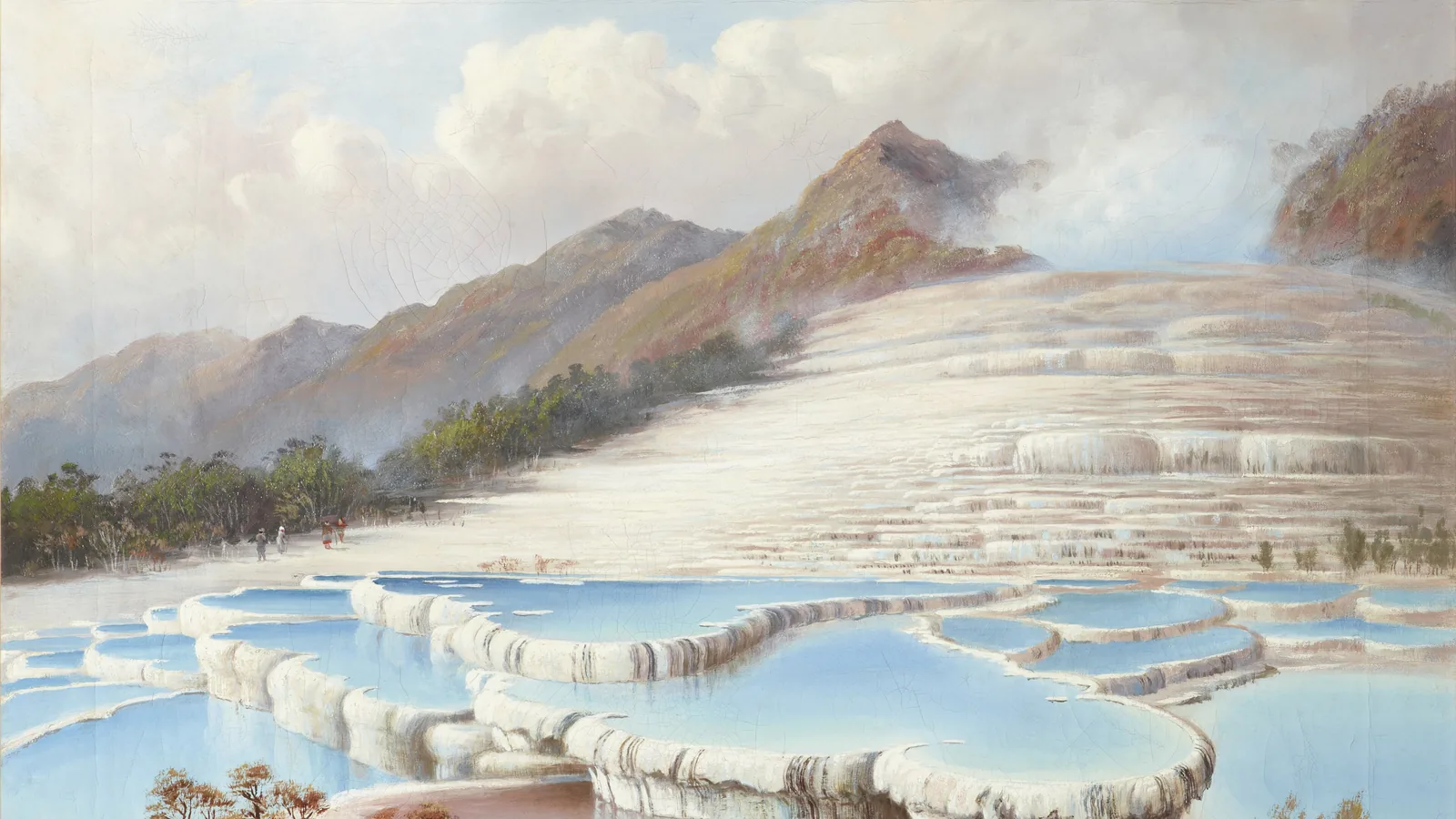
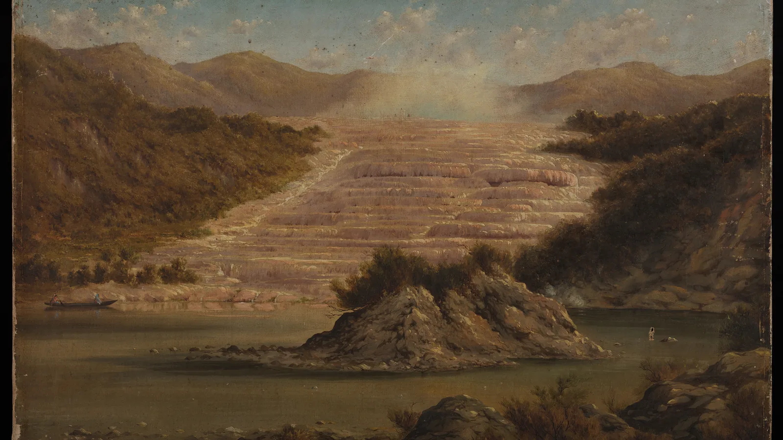
Before 1886, Lake Rotomahana was only about 20 percent of its later size, according to the GNS Science account. On its shores lay seven and a half acres of white silica terraces called Te Tarata and five and a half acres of pink terraces formed by the waters of Te Otukapuarangi. The archaeologist Alexy Simmons, in her 1991 report on Te Wairoa, wrote that the so-called “eighth natural wonder of the world” had reached prominence on the itinerary of overseas visitors in the 1870s. The novelist Anthony Trollope, who came in 1874, described bathing in the waters of the Pink Terraces as “intense sensual enjoyment.”
The Tūhourangi people owned the land and controlled access to the terraces. They supplied guides, canoes and dance concerts in the meeting house Hinemihi, and two women, Sophia Hinerangi and Kate Middlemiss, began a tradition of female guides. The artist Charles Bloomfield described the traffic: “The tourist came every weekday, from 10 to 30 of them, mostly moneyed people, from all parts of the world.” Visitors saw the White Terrace first, ate potatoes and freshwater crayfish cooked in a boiling spring, then crossed to the Pink Terraces to bathe. By the 1880s Te Wairoa had two hotels, Joseph McCrae’s 25-room Rotomahana Hotel and the smaller Terrace Hotel.
June 10, 1886: five hours of mud and scoria
About 120 Tūhourangi and about 15 Europeans lived at Te Wairoa at the time, Simmons recorded. The tourist season was over, and only three guests were staying in the hotels. Māori from other villages had come for a tangi, a funeral, and many of them did not survive the night.
After the earthquake, several European residents saw Tarawera “throwing great balls of fire into the lake.” A wind rose, and what people took for rain became a fall of mud, stone and cinders. Residents sheltered in two whare, or houses, and in Hinemihi, propping the roofs against the weight and putting out fires lit by burning cinders. Many of those who ran for other shelter lost their way in the dark and were killed by the falling debris.
The GNS Science fact sheet puts the start at 1:30 a.m. and the length at about five hours. A 2016 study in the Bulletin of Volcanology by Jenny Schauroth and colleagues describes a basaltic eruption that began in the northeast, in the Wahanga dome, and ran about 17 kilometers southwest along a fissure. Where the rift crossed Lake Rotomahana, heat from the magma turned the water to superheated steam and shattered the lakebed into a fine “Rotomahana Mud,” heavy enough to collapse buildings. Half a cubic kilometer of lake-floor material was thrown out. The blast was heard as far away as Blenheim, and ash affected the atmosphere as far south as Christchurch. The eruption also dammed the lake’s old outlet, and over time the water rose to form a much larger and deeper Lake Rotomahana.
The cause was argued within a year. Professor Hutton published a report, with which Professors Thomas and Brown agreed, attributing the heat to molten rock rising from depth. On June 8, 1887, J. Hardcastle told the Hawke’s Bay Philosophical Institute that the explanation was “so much at variance with the probabilities of the case, as to invite criticism.”
Digging out Te Wairoa, 1886 to 1990
At about 7:15 a.m., when the light allowed, survivors set out for Ohinemutu in Rotorua; a few turned back to dig people out. One of the first reporters on the scene counted probably 70 houses at Te Wairoa, with fewer than ten remaining: “Nearly all the large houses were destroyed.” Looters carried off stock from one of the two stores and took goods from private houses.
Visitors were coming to the “Buried Village” soon after. In 1931 the site was sold to Reginald Smith, and in the early 1930s his sons Dudley and Basil began uncovering buried houses while clearing pasture. The first professional archaeology followed in November 1989, when the collection was catalogued, and the excavation Simmons reported ran from January 8 to February 2, 1990.
Her team opened one whare, Whare A, 4.40 by 2.60 meters, capped by 50 to 70 centimeters of wet grey mud and scoria. Inside were a wicker-seated chair by the hearth, a table, two pairs of adult shoes of different sizes and, just outside the front, an 1883 shilling. Shells of kakahi, freshwater mussels, lay on the table and in the hearth; Simmons wrote that the occupants may have been eating them on the evening of the eruption. In the hotel kitchen the diggers found lamb stew in preparation and an upturned tray of glasses.
Sonar in the lake, survey bearings on the shore
GNS Science and the Woods Hole Oceanographic Institution, with help from the University of Waikato and the Te Arawa Lakes Trust Board, surveyed the lake floor over several years with side-scan sonar, seismic equipment, heat-flow and magnetic instruments and underwater cameras. Bunn dates the project’s first reports to 2011. The GNS Science account republished on May 28, 2024 states that the survey found “remnants of the Pink Terraces sitting below the lake surface,” while the White Terraces “appear to have been destroyed.” The same work found a body of magma about 2 kilometers below the lake floor at its shallowest.
Bunn, an independent researcher from Newcastle in New South Wales, disputes the lake finding. His 2023 paper in Frontiers in Earth Science describes the 2011 project as claiming both the Pink and White Terraces underwater and states that it “produced no sinter samples,” and he wrote that he had suggested its sonar images were misinterpreted. His evidence is a land survey: compass bearings taken in 1859 by the geologist Ferdinand Hochstetter, found in Europe in 2010 and reconstructed by Bunn and S. Nolden from 2016. Bunn cross-checked the bearings against old streams, landmarks and Māori navigation knowledge, and concluded that the White Terraces “lie on land, on the shoreline outside the 1886 crater.” He noted that Alfred Warbrick, a Māori expert who lived from 1860 to 1940, had believed the terraces survived buried in ash. Bunn’s paper, published on March 28, 2023, states that the sites are covered with ejecta from 1886 and that altimetry is needed to calculate how deeply the terraces are buried.
.jpg)
Key facts
- The eruption of June 10, 1886 began about 1:20 a.m. by Simmons’s account, or 1:30 a.m. by the GNS Science fact sheet, and lasted about five hours (Simmons 1991; GNS Science).
- It opened a rift about 17 kilometers long from the Wahanga dome across Tarawera, through Lake Rotomahana and into the Waimangu Valley area (GNS Science; Schauroth and others 2016).
- GNS Science’s fact sheet gives more than 100 dead; the 2024 GNS Science account published by Universities New Zealand gives 120.
- About 120 Tūhourangi and about 15 Europeans lived at Te Wairoa, and roughly a meter of mud and scoria fell on the village (Simmons 1991).
- The White Terraces, Te Tarata, covered seven and a half acres and the Pink Terraces five and a half (Simmons 1991).
- The first professional excavation at Te Wairoa ran from January 8 to February 2, 1990 (Simmons 1991).
- The lake survey reported Pink Terrace remnants under Lake Rotomahana; Bunn’s 2023 paper places the White Terraces on land outside the 1886 crater.
FAQ
How many people died in the 1886 Tarawera eruption?
The figure depends on the source. The GNS Science fact sheet states that more than 100 people were killed in villages near the mountain, and the GNS Science account published by Universities New Zealand in 2024 gives 120 deaths.
Do the Pink and White Terraces still exist?
The lake survey led by GNS Science and the Woods Hole Oceanographic Institution reported remnants of the Pink Terraces below the surface of Lake Rotomahana and found the White Terraces apparently destroyed. A. Rex Bunn's 2023 paper places the White Terraces on land, buried under 1886 ejecta outside the eruption crater.
What was found when Te Wairoa was excavated?
The 1990 excavation opened one house and part of the Rotomahana Hotel. It found a chair by the hearth, two pairs of shoes, freshwater mussel shells on the table and an 1883 shilling outside the front, and in the hotel kitchen a lamb stew in preparation.
How long did the Tarawera eruption last?
About five hours. Simmons's summary of the Te Wairoa accounts places the first earthquake around 1:20 a.m. and the end around 6:30 a.m. on June 10, 1886.
Sources
- GNS Science, "Volcano Fact Sheet: Tarawera Volcano and the Okataina Volcanic Centre" (PDF): start time, duration and length of the 1886 rift, Rotomahana Mud, the death toll, and how far the eruption was heard.
- Jenny Schauroth, Fabian B. Wadsworth, Ben Kennedy and others, "Conduit margin heating and deformation during the AD 1886 basaltic Plinian eruption at Tarawera volcano, New Zealand," Bulletin of Volcanology 78 (2016), article 12, via PubMed Central.
- Alexy Simmons, "Te Wairoa, The Buried Village: A Summary of Recent Research and Excavations," Australian Historical Archaeology 9 (1991), Australasian Society for Historical Archaeology.
- Universities New Zealand – Te Pōkai Tara, "Century-old eruption mystery solved by US and NZ scientists," May 28, 2024 (article courtesy of Science NZ and GNS Science).
- A. Rex Bunn, "Resolving the 1886 White Terraces riddle in the Taupō Volcanic Zone," Frontiers in Earth Science 11 (2023), article 1007148, published March 28, 2023, doi:10.3389/feart.2023.1007148.
- J. Hardcastle, "Art. XXXVII. The Tarawera Eruption, 10th June, 1886: A Criticism of Professor Hutton's (and others') Explanations of the Causes of the Eruption," Transactions and Proceedings of the New Zealand Institute 20 (1887), p. 277, read June 8, 1887 (Internet Archive copy of the National Library of New Zealand page).
Cite this article
- APA
- LETTER. (2026, September 28). Lake floor or dry land: the terraces Tarawera took on June 10, 1886. Our Earth's History. https://ourearthshistory.com/oceania/modern/tarawera-june-10-1886-pink-white-terraces-te-wairoa-lake-or-land/
- Chicago
- LETTER. “Lake floor or dry land: the terraces Tarawera took on June 10, 1886.” Our Earth's History, September 28, 2026. https://ourearthshistory.com/oceania/modern/tarawera-june-10-1886-pink-white-terraces-te-wairoa-lake-or-land/.
- MLA
- LETTER. “Lake floor or dry land: the terraces Tarawera took on June 10, 1886.” Our Earth's History, 28 Sep. 2026, https://ourearthshistory.com/oceania/modern/tarawera-june-10-1886-pink-white-terraces-te-wairoa-lake-or-land/.
Text licensed CC BY-NC-ND 4.0. Found an error? Tell us.