How were five Central Asian republics' borders drawn, 1917 to 1936?
.svg)
TL;DR — Moscow drew them in late 1924 and early 1925, one republic per nationality, over lands whose old states had been dynasties, then promoted and redrew the units until 1936.
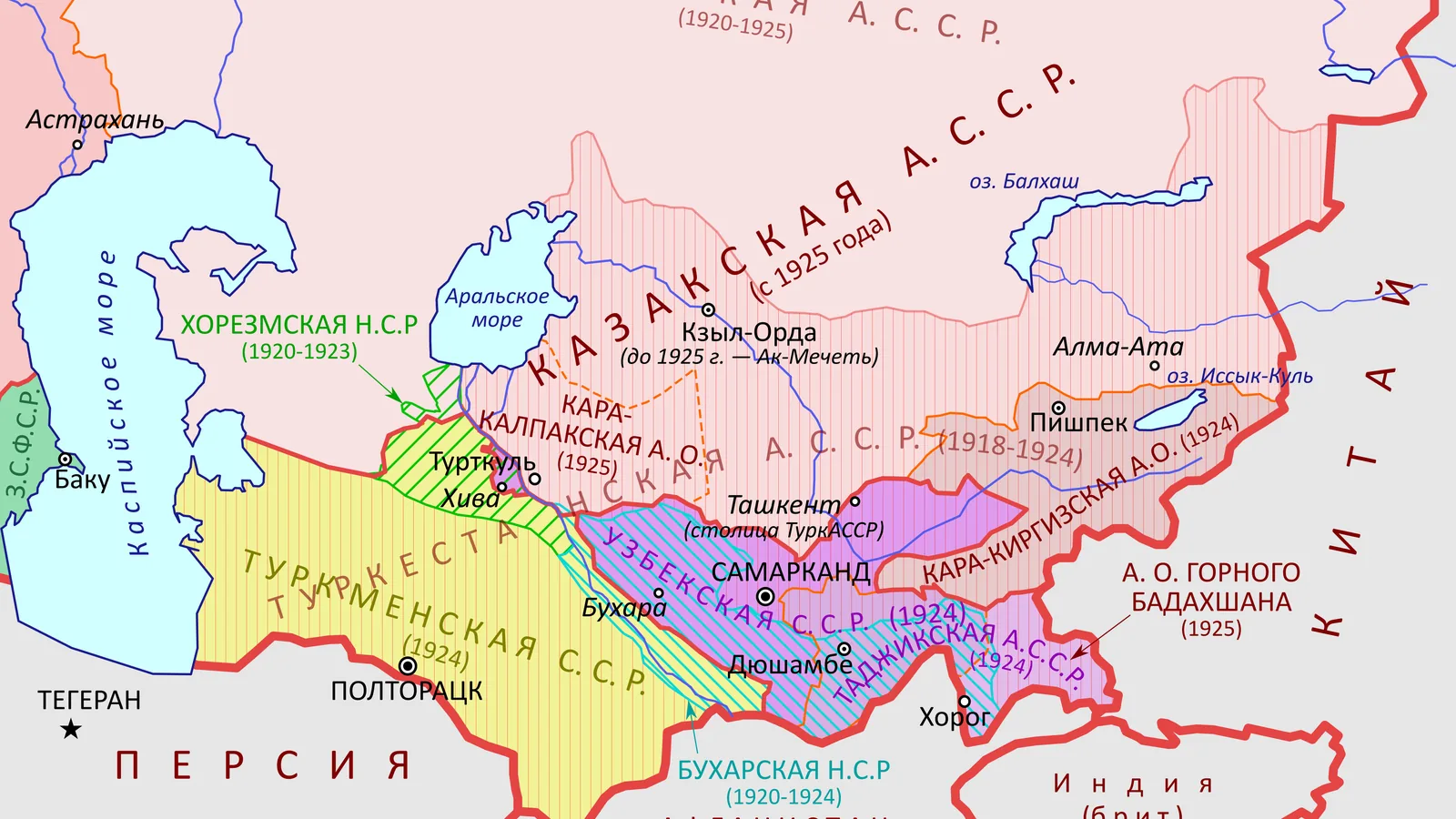
The Bolshevik government in Moscow drew the borders of Soviet Central Asia in late 1924 and early 1925, one unit for each nationality, and adjusted them until 1936. The states there before, the emirate of Bukhara, the khanate of Khiva and the Russian governorate-general of Turkestan, had been ruled by dynasties or by a governor in Tashkent, and none had been defined by language. The measure was Joseph Stalin’s 1913 definition of a nation. The Uzbek and Turkmen Soviet Socialist Republics appeared in October 1924, with a Tajik autonomous republic inside Uzbekistan and a Kara-Kyrghyz autonomous region; Tajikistan became a union republic in 1929, Kazakhstan and Kyrgyzstan in 1936. Those five lines became international borders in 1991.
Quick facts
- When
- summer 1916 (conscription revolt) · December 1917 to February 1918 (Kokand autonomy) · February 1, 1920 (Khiva falls) · June 22, 1920 (Lenin's draft on Turkestan) · January 23, 1924 (siege of Khiva) · October 1924 (Uzbek and Turkmen SSRs) · 1925 (Kazak ASSR renamed) · 1929 (Tajik SSR) · 1936 (Kazakh and Kyrgyz SSRs)
- Where
- Tashkent and the Fergana valley, in what is now Uzbekistan; Bukhara and Khiva, the two former Russian protectorates; Orenburg and Almaty; Dushanbe, a village of 3,000 in 1920; Khorezm, where the last Basmachi siege of Khiva failed in 1924
- Who
- Vladimir Lenin and Joseph Stalin; the Jadid reformers and Fayzulla Khojaev of Bukhara; the Young Khivans and the Turkmen leader Jonayd Khan; the Alash Orda of the Kazakh steppe; the Basmachi fighters; the historians Edward Allworth, Yuri Bregel and Paolo Sartori
- Outcome
- the emirate of Bukhara, the khanate of Khiva and the Turkestan governorate were replaced in 1924 and 1925 by units named for nationalities; by 1936 there were five union republics whose lines became international borders in 1991
What was there in 1916
The map of 1916 was the one Russian armies had made between 1865 and 1884, described in the preceding article on the conquest. Bukhara and Khiva survived as protectorates, an emir and a khan on their thrones. In the summer of 1916 the tsarist government canceled the exemption of Central Asians from wartime conscription. According to the Library of Congress country study of Uzbekistan, published in 1996, demonstrations in what is now eastern Uzbekistan met reprisals, and the fighting spread into Kyrgyz and Kazakh land, where Russian seizure of grazing ground had already bred hostility. The Turkmenistan study of the same series called it “the anti-tsarist revolt of 1916 that swept through the whole of Turkestan.”
1917 to 1920: soviets, Kokand and the fall of two thrones
The tsarist regime collapsed in March 1917, and Tashkent followed at once. The governor-general’s administration gave way, the Uzbekistan study recorded, to a dual system of provisional government and soviet power that excluded the Muslim population from office. Local leaders, some of them Jadids, the Muslim reformers, set up an autonomous government at Kokand in the Fergana valley; Edward Allworth, in the Encyclopaedia Iranica, dated it from December 1917 to February 1918, and a Kazakh government at Orenburg to the spring of 1918. The Kazakhstan study named it the Alash Orda; it surrendered to the Bolsheviks in under two years.
Paolo Sartori and Yuri Bregel, in the Iranica entry on Khiva, recorded that Bolshevik troops entered Khorezm on December 25, 1919, that Khiva fell on February 1, 1920, and that the last khan abdicated. In April a congress of soviets, elected under Tashkent’s eye, proclaimed a Khorezmian People’s Soviet Republic. In Bukhara, the Jadid Fayzulla Khojaev helped the Red Army take the city in 1920 and became president of the Bukharan People’s Republic after the emir joined the resistance. Lenin set the terms on June 22, 1920, in a draft decision for the Politburo on Turkestan: power was to pass to local soviets “under the control of reliable Communists,” the question of dividing the republic into three parts was “not to be decided beforehand,” and the general task was “the overthrow of feudalism.”
The Basmachi
After the suppression of Kokand, the Uzbekistan study recorded, Jadids and other loosely connected groups began what Russians called the Basmachi revolt; the name was “a derogatory Slavic term that the fighters did not apply to themselves.” The guerrilla war lasted more than a decade. The Turkmenistan study wrote that Soviet sources treated it as a minor chapter, while “opposition was fierce and resulted in the death of large numbers of Turkmen.” Sartori and Bregel gave one campaign in detail: on January 23, 1924, the Turkmen leader Jonayd Khan and an ally named Aghaji Ishan, with about 2,000 men, besieged Khiva; the garrison held, and by April 8 Jonayd had fled into Iran. The revolt was crushed, the Uzbekistan study wrote, as the civil war ended and promises of local autonomy drew the population away.
1924: a map drawn by nationality
The unit of the new map was the nation as Stalin had defined it in 1913: “A nation is a historically constituted, stable community of people, formed on the basis of a common language, territory, economic life, and psychological make-up manifested in a common culture.” Allworth wrote that “partitioning Central Asia into monoethnic administrative units for the first time in history, the Russian politicians instituted the European notion of nationality and nation in this cosmopolitan, Eastern land.”
In the spring and summer of 1924, Sartori and Bregel recorded, the Khorezmian communists argued for keeping their republic as a separate economic region with its own irrigation system, a case the Russian scholar Vasilii Barthold supported. “But the new system of ‘national republics’ was already decided in Moscow.” The fifth Khorezmian congress voted its republic out of existence at the end of September 1924, and the new division was in place by February 1925. In October 1924 the Trans-Caspian district and Turkmen oblast of Turkestan became the Turkmen SSR. The Uzbek SSR took in what is now Uzbekistan and Tajikistan, the latter as a Tajik autonomous republic of about 740,000 people out of nearly 5 million, with its capital at Dushanbe, a village of 3,000 in 1920. The Kyrgyz received the Kara-Kyrghyz Autonomous Region. The Tajikistan study recorded the official rationale: the redrawing fulfilled nationalist aspirations and would undercut support for the Basmachi.
1925 to 1936: promotions, famine and the purge
The unit set up in 1920 was called the Kyrgyz Autonomous Soviet Socialist Republic, because the Russian Empire had called both peoples “Kyrgyz” to avoid confusing “Kazak” with “Cossack.” It was renamed the Kazak ASSR in 1925, lost its capital, Orenburg, to Russia the same year, and moved to Almaty. In 1936 it became a union republic, as did Kyrgyzstan, an autonomous republic since 1926. Tajikistan had been separated from Uzbekistan in 1929, with northern territory added. By 1936, Allworth wrote, the array of five union republics and the Karakalpak ASSR inside Uzbekistan “seemed complete.”
From 1929 to 1934, the Kazakhstan study recorded, the republic endured repeated famines after herders slaughtered their livestock in protest; “at least 1.5 million Kazaks and 80 percent of the republic’s livestock died.” Kazakh, first written in Arabic script in the 1860s, was switched to Latin letters in 1929 and to a modified Cyrillic in 1940. Khojaev, by then Uzbek party chief, was arrested and executed with his whole circle in the purges of the late 1930s; Allworth gave his dates as 1896 to 1938.
What remains open
Whether the lines matched the people is the question the sources leave. Allworth wrote that “if they seriously tried to accomplish this, the politicians failed to a noticeable degree in the effort”: many Tajiks, above all those around Samarkand and Bukhara, and many Kazakhs found themselves inside Uzbekistan, and Uzbeks made up over 20 percent of the Tajik ASSR, by F. Lorimer’s 1946 population figures. The Tajikistan study agreed that the new boundaries “still left national groups fragmented.” The map of 1936 was drawn in Moscow on a definition written in 1913, over states that had been dynasties, and it is the map that still stands.
Key facts
- Summer 1916: a conscription decree set off revolt from the Fergana valley to the Kazakh steppe (Library of Congress, Uzbekistan).
- Kokand’s autonomous government lasted December 1917 to February 1918; the Alash Orda state, 1918 to 1920 (Allworth; Library of Congress, Kazakstan).
- Khiva fell February 1, 1920; the Khorezmian People’s Soviet Republic was proclaimed at the end of April (Sartori and Bregel).
- Lenin, June 22, 1920: the division of Turkestan “not to be decided beforehand”; the task was “the overthrow of feudalism.”
- October 1924: Uzbek and Turkmen SSRs, Tajik ASSR and Kara-Kyrghyz Autonomous Region; Kazak ASSR renamed 1925; Tajik SSR 1929; Kazakh and Kyrgyz SSRs 1936.
- Tajik ASSR at creation: about 740,000 people of nearly 5 million in the Uzbek SSR; Dushanbe had 3,000 people in 1920.
- Kazakh famine, 1929 to 1934: “at least 1.5 million Kazaks and 80 percent of the republic’s livestock died” (Library of Congress, Kazakstan).
FAQ
Why did the Soviet Union divide Central Asia by nationality?
The official rationale, recorded in the Library of Congress study of Tajikistan, was that the new units fulfilled local nationalist aspirations and would undercut support for the Basmachi. The definition of a nation used was Stalin's of 1913: common language, territory, economic life and culture. Allworth wrote that it was the first partition of the region into monoethnic units in its history.
What happened to Bukhara and Khiva?
Both lost their rulers in 1920 and became People's Soviet Republics. Sartori and Bregel recorded that the Khorezmian republic voted itself out of existence at the end of September 1924; the Bukharan republic went the same way, and their lands were divided among the Uzbek and Turkmen SSRs and the Tajik ASSR.
When did Kazakhstan and Kyrgyzstan become republics?
The Kazakh unit was an autonomous republic from 1920, renamed from "Kyrgyz" to "Kazak" in 1925, and a union republic in 1936. The Kara-Kyrghyz Autonomous Region of 1924 became an autonomous republic in 1926 and a union republic in 1936.
Sources
- Encyclopaedia Iranica — Edward Allworth, "Central Asia ix. In the 20th Century" (updated 2017).
- Encyclopaedia Iranica — Paolo Sartori and Yuri Bregel, "Khiva," with a section on 1917 to 1925.
- Marxists Internet Archive — V. I. Lenin, "Draft Decision for the Politbureau of the C.C., R.C.P.(B.) on the Tasks of the R.C.P.(B.) in Turkestan," June 22, 1920, Collected Works vol. 42.
- Marxists Internet Archive — J. V. Stalin, "Marxism and the National Question" (1913), Works vol. 2.
- Library of Congress, Federal Research Division, Country Studies: Uzbekistan (1996), chapters "The Jadidists and Basmachis" and "The Stalinist Period," via countrystudies.us.
- Library of Congress, Federal Research Division, Country Studies: Kazakstan (1996), chapters "In the Soviet Union" and "Language," via countrystudies.us.
- Library of Congress, Federal Research Division, Country Studies: Kyrgyzstan (1996), chapter "The Soviet Union and Recent History," via countrystudies.us.
- Library of Congress, Federal Research Division, Country Studies: Turkmenistan (1996), chapter "Soviet Turkmenistan," via countrystudies.us.
- Library of Congress, Federal Research Division, Country Studies: Tajikistan (1996), chapter "Creation of Tajikistan," via countrystudies.us.
Cite this article
- APA
- Our Earth's History. (2026, September 21). How were five Central Asian republics' borders drawn, 1917 to 1936? Our Earth's History. https://ourearthshistory.com/central-asia/contemporary/soviet-central-asia-borders-1924/
- Chicago
- Our Earth's History. “How were five Central Asian republics' borders drawn, 1917 to 1936?” Our Earth's History, September 21, 2026. https://ourearthshistory.com/central-asia/contemporary/soviet-central-asia-borders-1924/.
- MLA
- “How were five Central Asian republics' borders drawn, 1917 to 1936?” Our Earth's History, 21 Sep. 2026, https://ourearthshistory.com/central-asia/contemporary/soviet-central-asia-borders-1924/.
Text licensed CC BY-NC-ND 4.0. Found an error? Tell us.