Aral Sea: 68,000 square kilometers in 1960, no eastern basin by 2014
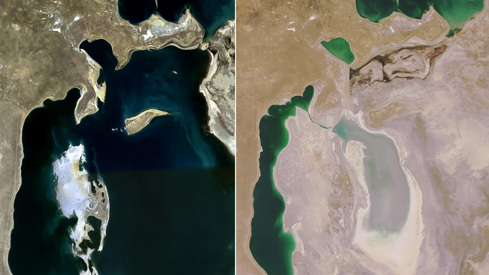

TL;DR — Soviet cotton irrigation cut the Aral Sea’s inflow to zero by the early 1980s. The eastern basin vanished in 2014; only the north, behind a 2005 dike, refilled.
NASA’s Earth Observatory gave one year in its satellite record of the Aral Sea a single sentence: “In 2014, the eastern lobe of the South Aral Sea completely disappeared.” In 1960 the same lake, on the border of what are now Kazakhstan and Uzbekistan, “covered about 68,000 square kilometers” and “was the 4th largest lake in the world,” in the words of the U.S. Geological Survey; the Food and Agriculture Organization of the United Nations (FAO) puts the pre-1960 surface at about 66,000 square kilometers, the IFAS agency in Uzbekistan at 69,790. In the 1960s the Soviet Union turned its two rivers, the Amu Darya and the Syr Darya, into irrigation water for cotton. Inflow fell to zero by the early 1980s, and by the end of that decade the sea had split in two. Kazakhstan, with a World Bank loan, closed a 13-kilometer dike across the gap in August 2005, and the North Aral Sea rose from 38 to 42 meters. The south was left to go.
Quick facts
- When
- 1960 (about 68,000 square kilometers, the fourth largest lake in the world) · 1965 (about 50 cubic kilometers of river water a year) · early 1980s (inflow near zero, commercial fishing ended) · end of the 1980s (the sea split into north and south) · January 4 and March 26, 1993 (IFAS founded) · 2001 (Vozrozhdeniya Island joined the mainland) · August 2005 (Kok-Aral dike completed) · 2014 (eastern lobe of the South Aral Sea disappeared) · April 2025 (ESA expects the southern part to dry entirely)
- Where
- the Aral Sea, on the border of what are now Kazakhstan and Uzbekistan; the Amu Darya and Syr Darya rivers; the Kara Kum canal in Turkmenistan; the ports of Aralsk (Kazakhstan) and Muynak (Uzbekistan); the Berg Strait; Vozrozhdeniya Island
- Who
- the Soviet government and its irrigation planners; the fishermen of Aralsk and Muynak; the government of Kazakhstan and the World Bank; the International Fund for Saving the Aral Sea (IFAS) under Nursultan Nazarbayev; the analysts of NASA, USGS, ESA, FAO and UNEP who measured the retreat
- Outcome
- river inflow fell to zero by the early 1980s and the sea split; the eastern basin of the South Aral Sea disappeared in 2014. The Kok-Aral dike of August 2005 raised the North Aral Sea from 38 to 42 meters, cut its salinity to under 10 grams per liter and brought the catch from 52 tons in 2004 to 2,834 tons in 2007; the southern sea is expected to dry entirely
Cotton and the Kara Kum canal
NASA’s caption to its image series describes what changed: the rivers “were used to transform the desert into farms for cotton and other crops.” Irrigated land in the Soviet part of the basin, FAO recorded in 1997, grew from about 4.5 million hectares in 1960 to 7 million in 1980 and 8 million in 1995, and water withdrawals rose from 64.7 cubic kilometers in 1960 to 120 in 1980.
The largest single diversion was the Kara Kum canal in Turkmenistan, which FAO wrote “was constructed in the 1950s and is, with its some 1 300 km, the longest canal in the world,” with a capacity of 630 cubic meters a second. Between 1975 and 1988, by IFAS Kazakhstan’s figure, the canal alone took 10 to 13.5 cubic kilometers a year from the Amu Darya.
Aralsk to Muynak, 250,000 tons a year
The sea before the diversions was a working waterway. IFAS Kazakhstan records that ships between Aralsk in the north and Muynak in the south carried 250,000 tons a year of cotton, grain, salt, fish, chemicals and timber. NASA’s 2001 caption reads that the fishery employed “roughly 60,000 people in the early 1960s. By 1977, the fish harvest was reduced by 75 percent, and by the early 1980s the commercial fishing industry had been eliminated.”
The water was going. In 1965, NASA wrote, the sea still received about 50 cubic kilometers of fresh water a year, “a number that fell to zero by the early 1980s.” From 1974 to 1986, IFAS Kazakhstan records, the Syr Darya did not reach the sea at all. The same office dates the end of fishing to 1984, when salinity had passed 20 grams per liter; FAO gives 1982.
.jpg)
By the end of the 1980s, two seas
Landsat images from 1973 to 2000 led NASA to write in May 2001 that “in the last 30 years, more than 60 percent of the lake has disappeared.” The falling level dried the Berg Strait and cut the sea into a small northern sea in Kazakhstan and a large southern one. The year is 1987 in one NASA caption, 1989 in another and in the account of the IFAS agency in Uzbekistan, and 1990 in the World Bank’s 2008 brief; the European Space Agency (ESA) writes “by the end of the 1980s.”
The south then broke again. At the start of NASA’s series in 2000 the South Aral Sea had split into eastern and western lobes “that remained tenuously connected at both ends.” By 2001 the southern connection had been severed, and the shallower eastern lobe retreated fastest between 2005 and 2009, “when drought limited and then cut off the flow of the Amu Darya.” In 2014 it was gone.
"Contaminated with agricultural chemicals"
“The blowing dust from the exposed lakebed, contaminated with agricultural chemicals, became a public health hazard,” NASA’s caption reads. UNEP and GRID-Arendal’s Vital Water Graphics states that “about 200,000 tonnes of salt and sand are carried by the wind from the Aral Sea region every day, and dumped within a 300 km radius,” and that “the incidence of typhoid fever, viral hepatitis, tuberculosis and throat cancer is three times the national average in some areas.”
One island had a second history. Vozrozhdeniya, whose name NASA translates as “rebirth,” “was the home of biological weapons lab in 1966,” in the words of the 2012 caption. NASA’s images of June 2000 and June 2001 showed the channel separating it from the mainland gone within a year, so that animals on the island “now have easy access to the mainland, and vice versa.” A U.S.-Uzbek team decontaminated the former island in 2002.
Kok-Aral, 13 kilometers, and the sea that was left
The Central Asian states agreed at a summit to found the International Fund for Saving the Aral Sea at Tashkent on January 4, 1993, and signed its charter at Kyzylorda on March 26; Nursultan Nazarbayev of Kazakhstan was its first president. By August 2003 NASA could write that “the southern Aral Sea has been deemed beyond salvaging, and the restoration effort will instead focus on the much smaller, but less polluted and saline, northern sea.” The World Bank approved a loan of US$64.5 million for Kazakhstan’s Syr Darya Control and Northern Aral Sea project on June 5, 2001, and its 2008 brief records that “the 13 km Kok-Aral Dike was constructed to separate the Northern Aral Sea from the South Aral Sea. Completion was in August 2005.”
The bank’s completion report of 2011 gives the result. The North Aral rose “from a pre-project low of 38 m to the desired design level of 42 m,” and NASA saw it in April 2006 “filling up more rapidly than planners expected.” The surface grew from 2,400 square kilometers in 2001 to 3,300 in 2009, salinity fell from more than 20 grams per liter to under 10, and the catch went from 52 tons in 2004 to 2,834 tons in 2007. The report puts Aralsk harbor 75 kilometers from the water in 2001 and 35 in August 2010; the bank’s other documents give other pairs, 100 to 25 and 75 to about 20.
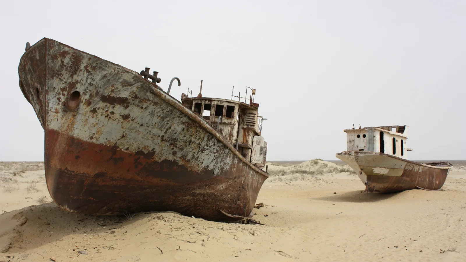
South of the dike the water kept leaving. Muynak kept what a UN Uzbekistan article of January 2024 called its “haunting ship cemetery,” and a World Bank photo caption of June 2021 reads “Graveyard of ships in the Aral Sea.” ESA wrote in April 2025 that it expected the southern part of the sea to dry out entirely, and that the Small Aral was the focus of the international effort to keep any of it.
Key facts
- In 1960 the Aral Sea “covered about 68,000 square kilometers” and “was the 4th largest lake in the world” (USGS); FAO gives about 66,000 square kilometers, IFAS Uzbekistan 69,790.
- Irrigated land in the Soviet Aral basin rose from about 4.5 million hectares in 1960 to 8 million in 1995; withdrawals from 64.7 to 120 cubic kilometers a year between 1960 and 1980 (FAO, 1997).
- The Kara Kum canal in Turkmenistan, built in the 1950s, runs some 1,300 kilometers with a capacity of 630 cubic meters a second (FAO).
- River inflow of about 50 cubic kilometers a year in 1965 “fell to zero by the early 1980s”; the Syr Darya did not reach the sea from 1974 to 1986 (NASA; IFAS Kazakhstan).
- The fishery employed roughly 60,000 people in the early 1960s and was gone by the early 1980s (NASA); shipping between Aralsk and Muynak had carried 250,000 tons a year (IFAS Kazakhstan).
- The sea split into north and south by the end of the 1980s; NASA, IFAS and the World Bank give 1987, 1989 and 1990. “In 2014, the eastern lobe of the South Aral Sea completely disappeared” (NASA).
- The 13 km Kok-Aral dike was completed in August 2005 with a World Bank loan of US$64.5 million; the North Aral rose from 38 to 42 meters and the catch from 52 tons in 2004 to 2,834 tons in 2007 (World Bank, 2008 and 2011).
- Vozrozhdeniya Island, site of a biological weapons lab from 1966, joined the mainland in 2001 and was decontaminated by a U.S.-Uzbek team in 2002 (NASA; USGS).
FAQ
Why did the Aral Sea dry up?
The Soviet Union diverted the Amu Darya and Syr Darya in the 1960s to irrigate cotton and other crops, through works such as the 1,300-kilometer Kara Kum canal. FAO records withdrawals rising from 64.7 to 120 cubic kilometers a year between 1960 and 1980; NASA records the sea's inflow falling from about 50 cubic kilometers a year in 1965 to zero by the early 1980s.
Has any part of the Aral Sea recovered?
The North Aral Sea in Kazakhstan has. After the 13-kilometer Kok-Aral dike was completed in August 2005, the World Bank's 2011 report recorded the level rising from 38 to 42 meters, salinity falling below 10 grams per liter and the catch rising from 52 tons in 2004 to 2,834 tons in 2007.
What happened to Vozrozhdeniya Island?
NASA's caption describes it as the home of a biological weapons lab in 1966. As the sea fell, the channel separating it from the mainland vanished between the summers of 2000 and 2001, and a U.S.-Uzbek team decontaminated the former island in 2002.
Sources
- NASA Earth Observatory, "World of Change: Shrinking Aral Sea" (Terra MODIS image series, 2000–2018, with caption).
- NASA Earth Observatory, "The Shrinking Aral Sea" (Image of the Day, May 5, 2001; Landsat 1973–2000) and "Aral Sea" (Image of the Day, August 25, 2003; Landsat 1989 and 2003).
- NASA Earth Observatory, "The Aral Sea, Before the Streams Ran Dry" (Image of the Day, February 24, 2012; Argon KH-5 image of August 22, 1964) and "'Rebirth' Island Joins the Mainland" (Image of the Day, August 25, 2001).
- NASA Earth Observatory, "Aral Sea Expansion" (Image of the Day, April 11, 2006; MODIS April 8, 2005 and April 9, 2006).
- U.S. Geological Survey, EROS, Earthshots: Satellite Images of Environmental Change, "Aral Sea, Kazakhstan and Uzbekistan" (entries on the Aral Sea, Aralsk, the islands and the Kok-Aral Dam).
- FAO, Irrigation in the countries of the former Soviet Union in figures (Water Report 15, 1997): "The Aral Sea basin" and the "Turkmenistan" chapter (Kara Kum canal).
- Executive Board of the International Fund for Saving the Aral Sea in Kazakhstan (ifas.kz), "Sea in Soviet times," "Modern history of Aral" and "Memorable dates."
- Agency of IFAS for implementation of the Aral Sea basin projects, Uzbekistan (aral.uz), "Crisis of the Aral Sea" and "History of IFAS."
- UNEP / GRID-Arendal, "The disappearance of the Aral Sea," Vital Water Graphics 2 (2009; map by Philippe Rekacewicz, February 2006).
- World Bank, Water Feature Stories issue 23 (October 2008), "Innovative Approaches to Ecosystem Restoration: Kazakhstan's Syr Darya Control and Northern Aral Sea Phase I Project" (Report no. 46236).
- World Bank, Implementation Completion and Results Report (IBRD-46090) on a Loan for the Syr Darya Control and Northern Aral Sea Phase I Project (ICR0000874, June 29, 2011).
- ESA, "Earth from Space: The shrinking Aral Sea" (April 2025).
- United Nations in Uzbekistan, "Blossoming Hope: Aral Sea's Dried Bed Unleashes Healing Power through Beekeeping" (January 25, 2024), and World Bank, "In Search of a Desert Oasis" (June 17, 2021), photo caption.
Cite this article
- APA
- Our Earth's History. (2026, September 22). Aral Sea: 68,000 square kilometers in 1960, no eastern basin by 2014. Our Earth's History. https://ourearthshistory.com/central-asia/contemporary/aral-sea-1960-2014-kok-aral-dam-north-aral/
- Chicago
- Our Earth's History. “Aral Sea: 68,000 square kilometers in 1960, no eastern basin by 2014.” Our Earth's History, September 22, 2026. https://ourearthshistory.com/central-asia/contemporary/aral-sea-1960-2014-kok-aral-dam-north-aral/.
- MLA
- “Aral Sea: 68,000 square kilometers in 1960, no eastern basin by 2014.” Our Earth's History, 22 Sep. 2026, https://ourearthshistory.com/central-asia/contemporary/aral-sea-1960-2014-kok-aral-dam-north-aral/.
Text licensed CC BY-NC-ND 4.0. Found an error? Tell us.