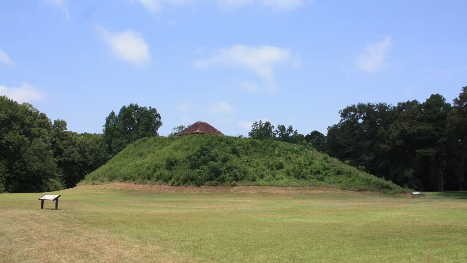
Mound B and the plaza at Moundville: a town that became a necropolis

TL;DR — Moundville, on Alabama’s Black Warrior River, was a walled town from about AD 1200 to 1300, then emptied into a regional burial center before its abandonment.
By AD 1250 a town of square wattle-and-daub houses stood behind a bastioned palisade on a bluff 17 meters above the Black Warrior River in west-central Alabama, around a plaza lined with earthen mounds. That is the reconstruction in “A New History of Moundville,” the opening chapter of Archaeology of the Moundville Chiefdom, by Vernon James Knight Jr. of the University of Alabama and Vincas P. Steponaitis, published in 1998 and reissued in 2007. After 1300 most residents moved out, and Moundville became “a necropolis, a center of mortuary ritual for the region as a whole.” The University of Alabama Museums, which run the site as Moundville Archaeological Park, date its occupation from around AD 1000 until AD 1450.
Quick facts
- When
- About AD 1200 (palisade built, mound construction begins) · about 1300 (most residents leave) · about 1500 to 1650 (abandonment, by different accounts) · 1905 and 1907 (Moore's reports) · 1933 (Mound State Park) · May 16, 1939 (museum opens) · July 19, 1964 (National Historic Landmark) · August 30, 2022 (NAGPRA notice)
- Where
- A terrace on the east bank of the Black Warrior River at Hemphill Bend, west-central Alabama, 24 kilometers south of the fall line; Hale County
- Who
- Mississippian residents of the Black Warrior Valley; Vernon James Knight Jr. and Vincas P. Steponaitis; Christopher Peebles; Clarence B. Moore; the Civilian Conservation Corps; the University of Alabama Museums; the Muskogean-speaking tribes named in the 2022 notice
- Outcome
- A palisaded town of about 1200 to 1300 emptied after 1300 and served as a regional burial center; its mounds were abandoned by the late 1500s by Knight and Steponaitis's account, and the valley was depopulated about 1650
Hemphill Bend and the plaza
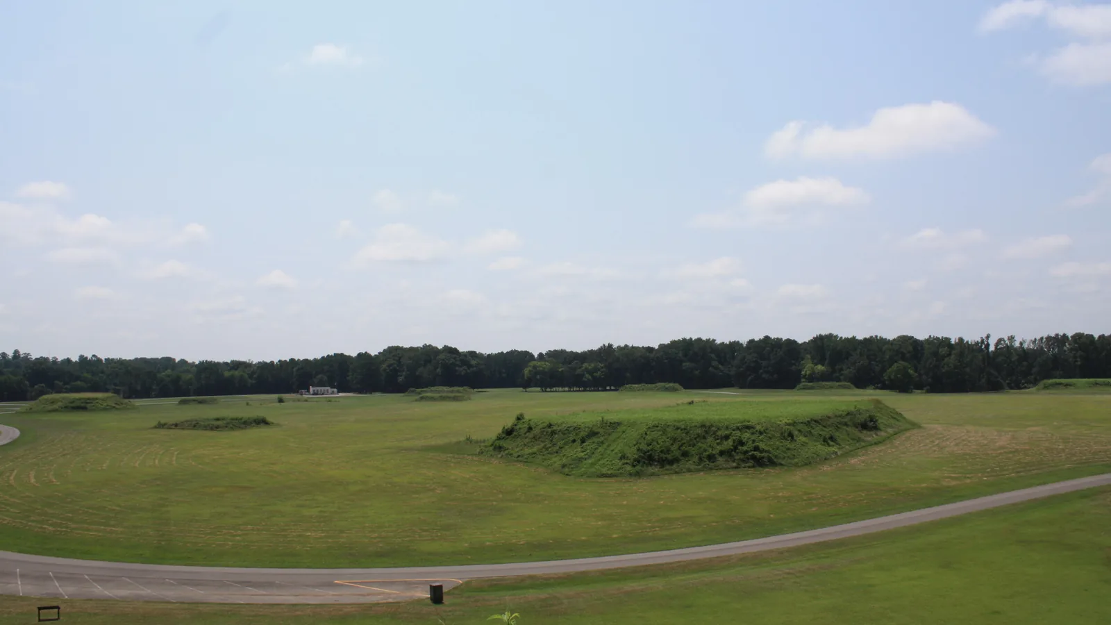
The site lies on a flat terrace on the east side of the river at Hemphill Bend, 24 kilometers south of the fall line. The larger mounds were set around the edges of a single four-sided plaza. Mounds M through Q formed a western row, I through L a southern row and F through H an eastern row, and Mound A stood in the middle. Mound B, the largest, is 17.3 meters high by Knight and Steponaitis’s measurement.
The count of mounds depends on the document. The park’s “Ancient Site” page gives twenty-six earthen mounds around the plaza. Knight and Steponaitis mapped 29 in an occupied zone of about 75 hectares (185 acres), 22 of them carrying letter names first used by Clarence B. Moore, and wrote that a topographic survey by an engineering firm in April 1930 marked three more low rises as artificial, “which would bring the total to 32.” In a 2009 paper Knight gave “more than 30 mounds.” The National Register nomination form held by the National Park Service counts 34 in the central group, 18 of them forming a hollow square. The park page gives the village at its height three hundred acres; the chapter gives 185.
About AD 1200: a palisade and a town
Radiocarbon dates from the northwest riverbank show the palisade was built around AD 1200 and rebuilt about six times before it went out of use around 1300. Because every mound with sherd data has a strong early component, Knight and Steponaitis argued that all the major mounds were begun between about AD 1200 and 1250. Houses between the plaza and the wall averaged about 19 square meters of floor.
Population figures vary by a factor of 10. Christopher Peebles’s estimate of 3,000 residents was the most often cited, according to Steponaitis. Knight and Steponaitis put the town’s population in this period at somewhat less than 1,000. In his own chapter Steponaitis derived 1,200 residents from sherd deposition and 1,050 to 1,680 from house density, then wrote: “I would be very surprised if Moundville’s permanent residents much exceeded 1,000, even during Moundville I times.” The Federal Register notice of 2022 described the site and surrounding area as inhabited by “several thousand people.”

Necropolis after 1300
After 1300 most of the population left, presumably for farmsteads scattered along the valley, and the palisade was never rebuilt. Knight and Steponaitis offered three possible reasons: an elite decision to make the center more sacred by emptying it, exhausted soil and firewood near the town, or a smaller threat of attack. Sherds from household refuse fall to about one-fourth of their earlier level in the Moundville II and III phases, while burials rise and peak in Moundville III. Most of the dead, in this reading, were brought in from outlying settlements. Steponaitis estimated 300 residents for those later phases, and Knight and Steponaitis gave the farmstead population of the valley as perhaps 10,000.
By AD 1400 many mounds had been abandoned, those on the southern edge of the plaza first. The park dates the change to about AD 1350: “The site lost the appearance of a town but retained its ceremonial and political functions.” Dates for the end differ. The National Register form has major centers such as Moundville abandoned by about AD 1500, Steponaitis wrote that by circa AD 1550 Moundville “was virtually abandoned as a settlement,” and Knight and Steponaitis placed the abandonment of every mound by the end of the 1500s. Villages in the valley lasted until about 1650, and the river became a buffer between proto-Creeks to the east and Choctaws to the west.
Clarence B. Moore and the Civilian Conservation Corps
Moore’s reports of 1905 and 1907 fixed the letter names. At Mound V in 1905, Knight wrote, Moore devoted “eighteen trial holes and 150 feet of narrow trench” to the summit and found no burials.
The land was later donated to the state, and Mound State Park was established in 1933, renamed Mound State Monument in 1938. The Civilian Conservation Corps, working with the National Park Service, restored the mounds and lakes. Knight wrote that the Mound V platform, like other mounds in the park, was “to some degree ‘restored’” in the late 1930s. The park’s history page records that the corps built the Jones Archaeological Museum, which opened on May 16, 1939, and that the workers’ cabins were segregated. A pavilion and a dry swimming hole from the camp remain on the grounds; the pool later served Black residents only. The National Park Service lists the Moundville Site in Hale County as a National Historic Landmark from July 19, 1964. The University of Alabama Museums began a $5 million renovation of the museum in 1999 and reopened it in 2010.
"Transfer of control": the 2022 notice
On August 30, 2022, the Federal Register published a Notice of Inventory Completion from the University of Alabama Museums. It recorded that between the 1930s and the late 1980s the remains of at least 9,954 individuals and 1,371 lots of funerary objects were excavated from Site 1Tu500, the Moundville site. The museums determined a cultural affiliation with the present-day Muskogean-speaking tribes, after consultation with seven tribes and nations, among them the Chickasaw Nation, the Choctaw Nation of Oklahoma and the Muscogee (Creek) Nation. The park’s page on the site’s ancient history describes the links between Moundville’s inhabitants and the historic tribes as “still not well understood.” The museum’s page for its 2010 exhibition, “Lost Realm of the Black Warrior,” states that many of its items have since been returned to descendant communities under the law. Other claimants had until September 29, 2022, to write to the museums, and if none came forward, the notice said, transfer to the listed tribes “may proceed.”
Key facts
- The University of Alabama Museums date Moundville’s occupation from around AD 1000 until AD 1450.
- Knight and Steponaitis date the palisade to around AD 1200, with about six rebuildings until about 1300.
- Mound counts: twenty-six (park page), 29 or 32 (Knight and Steponaitis), more than 30 (Knight 2009), 34 (National Register form).
- Mound B, the tallest, is 17.3 meters high (Knight and Steponaitis).
- Population estimates: 3,000 (Peebles), somewhat less than 1,000 (Knight and Steponaitis), 1,050 to 1,680 for the early town and 300 for the later phases (Steponaitis).
- Clarence B. Moore dug at Mound V in 1905; his reports appeared in 1905 and 1907.
- Mound State Park was established in 1933; the Jones Archaeological Museum opened on May 16, 1939; the Moundville Site became a National Historic Landmark on July 19, 1964.
- A Federal Register notice of August 30, 2022, recorded a completed inventory affiliating the Moundville collection with Muskogean-speaking tribes.
FAQ
How many mounds are at Moundville?
The figure depends on the source. The park's page gives twenty-six, Knight and Steponaitis mapped 29 and noted a 1930 survey that would make 32, Knight's 2009 paper gave more than 30, and the National Register nomination form counts 34.
How many people lived at Moundville?
Christopher Peebles estimated 3,000. Knight and Steponaitis put the town at somewhat less than 1,000 between AD 1200 and 1300, and Steponaitis estimated about 300 residents after 1300, when most people lived on farmsteads in the valley.
When was Moundville abandoned?
The National Register form gives about AD 1500, Steponaitis about AD 1550, and Knight and Steponaitis the end of the 1500s for the last mounds, with valley villages lasting until about 1650.
Sources
- University of Alabama Museums, Moundville Archaeological Park, "Ancient Site" (occupation dates, 300-acre village, palisade, twenty-six mounds, change about AD 1350).
- Vernon James Knight Jr. and Vincas P. Steponaitis, "A New History of Moundville," chapter 1 in Archaeology of the Moundville Chiefdom (Smithsonian Institution Press, 1998; reissued 2007), copy at the UNC Research Laboratories of Archaeology.
- Vincas P. Steponaitis, "Population Trends at Moundville," chapter 2 in Archaeology of the Moundville Chiefdom, copy at the UNC Research Laboratories of Archaeology.
- Vernon James Knight, "Discovery and Excavation of the Moundville Earth Lodge," Bulletin of the Alabama Museum of Natural History 27 (November 30, 2009): 20–28.
- National Park Service, National Register of Historic Places Inventory-Nomination Form, "Moundville Site" (Mound State Monument), NPGallery.
- National Park Service, "List of NHLs by State" (Alabama, Moundville Site).
- University of Alabama Museums, Moundville Archaeological Park, "Black History: The Civilian Conservation Corps."
- University of Alabama Museums, Moundville Archaeological Park, "Jones Archaeological Museum."
- Federal Register 87 FR 52995 (Document 2022-18741), "Notice of Inventory Completion: University of Alabama Museums, Tuscaloosa, AL," August 30, 2022.
Cite this article
- APA
- Song Letter. (2026, September 29). Mound B and the plaza at Moundville: a town that became a necropolis. Our Earth's History. https://ourearthshistory.com/americas/medieval/moundville-alabama-mounds-knight-steponaitis/
- Chicago
- Song Letter. “Mound B and the plaza at Moundville: a town that became a necropolis.” Our Earth's History, September 29, 2026. https://ourearthshistory.com/americas/medieval/moundville-alabama-mounds-knight-steponaitis/.
- MLA
- Song Letter. “Mound B and the plaza at Moundville: a town that became a necropolis.” Our Earth's History, 29 Sep. 2026, https://ourearthshistory.com/americas/medieval/moundville-alabama-mounds-knight-steponaitis/.
Get the week in history
One email a week: the new articles, and what was happening elsewhere at the same moment. Free, no ads, unsubscribe any time. How we handle your email.
Text licensed CC BY-NC-ND 4.0. Found an error? Tell us.