Monks Mound and 120 others: Cahokia on the Mississippi, 1050 to 1350

TL;DR — Monks Mound, the largest earthen mound in North America, anchored Cahokia, a Mississippian city of about 120 mounds in Illinois that rose about 1050 and was empty by 1350.
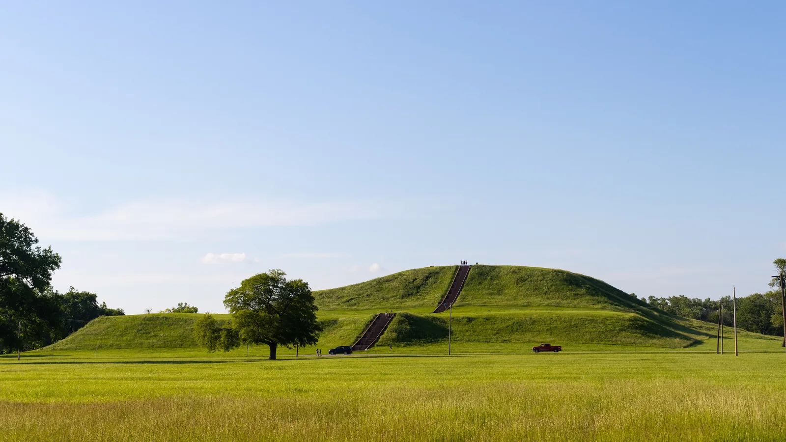
Monks Mound is the largest mound at Cahokia, a few miles west of Collinsville, Illinois, and, by the Cahokia Mounds State Historic Site’s description, the largest man-made earthen mound on the continent. At the 130-meter contour the site’s page gives it 291 meters north to south, 236 meters east to west and 28.1 meters high; the lower 128-meter contour gives 320 by 294 meters and 30.1 meters, and it puts the present height “in the vicinity of 100 feet (30.5 meters).” Around it, at the peak about 1100, the historic site counts about 120 earthen mounds over 4,000 acres and nearly 20,000 people, on the Mississippi floodplain near present-day St. Louis. The city rose about AD 1050 and was abandoned by 1350, on the dating that Samuel Munoz and colleagues published in PNAS in 2015.
Quick facts
- When
- Woodhenges built about AD 900 to 1100 · Cahokia's rise about 1050 · peak about 1100 · stockade begun about 1100 and rebuilt three times over 200 years · flood and drought about 1150 · large floods return after 1200 · abandonment by 1350
- Where
- The Mississippi River floodplain, called the American Bottom, near present-day St. Louis; the historic site lies a few miles west of Collinsville, Illinois
- Who
- Mississippian builders; the Cahokia Mounds State Historic Site; the Illinois State Archaeological Survey; Warren Wittry (Woodhenge); Samuel Munoz and colleagues (floods, 2015); A. J. White and colleagues (fecal stanols, 2019); Thomas Emerson and colleagues (Mound 72, 2016)
- Outcome
- A city of about 120 mounds by the historic site's count, or 200 earthen pyramids by the Illinois State Archaeological Survey's, with nearly 20,000 people; emptied by 1350 after large floods returned to the Mississippi
Four terraces and a name from monks
The mound took its name from Trappist monks who lived on one of the nearby mounds; they never lived on the big one, the historic site records, but gardened its first terrace. That terrace runs across the southern end and rises about 35 feet above the surrounding ground. Monks Mound is the only mound at Cahokia with more than two terraces, and every map and reconstruction shows four.
The figures have moved with the surveyor. McAdams reported a height of 108 feet in 1882 and Thomas 100 feet in 1894; a 1968 report on solid-core drilling gave the base as roughly 1,037 by 790 feet. Slope wash lies around the foot of the mound, the page says, and “only excavation can reveal its true base.” A projection on the south side, read as a ramp, yielded impressions of what may have been log steps in a 1971 excavation.
Two counts for one city
How big Cahokia was depends on which institution is counting. The historic site’s home page puts the peak about 1100 at 4,000 acres, about 120 earthen mounds and nearly 20,000 people, “larger than London at that time.” The Illinois State Archaeological Survey’s research page gives 200 earthen pyramids, three connected precincts and hundreds of rural settlements, with about 20,000 people in a 6-square-mile core and more than 50,000 in the region. Neither page explains the gap between 120 and 200. The state of Illinois protects roughly 2,200 acres of the central portion, with 72 of the nearly 80 mounds that remain.
Posts in circles, and a wall of 15,000 logs
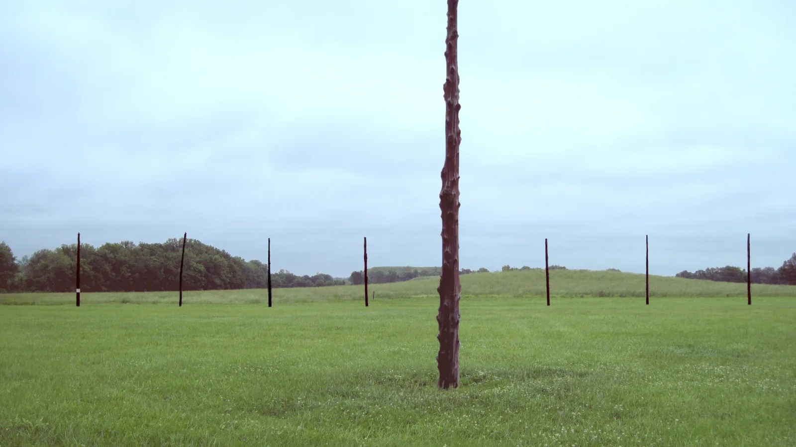
Woodhenge came to light by accident. In the early 1960s, digging ahead of an interstate highway, Warren Wittry saw on the excavation maps that large oval pits fell in arcs of circles and proposed that posts in them had lined up with the rising sun. Later digs found evidence for as many as five circles of red cedar posts, built between AD 900 and 1100, growing from 24 posts in the first to 60 in the fourth; the last had only 12 or 13 along the sunrise arc. The third circle, dated about AD 1000, was rebuilt in place in 1985, 410 feet across with 48 posts about 20 feet tall; the equinox post lined up with the front of Monks Mound.
Aerial photographs of the 1920s and 1930s showed light streaks in the fields near Monks Mound, and excavations begun in 1966 confirmed a stockade two miles long around the central part of Cahokia, started about AD 1100 and rebuilt three times over 200 years. Each construction took 15,000 to 20,000 oak and hickory logs, a foot thick and 20 feet tall, sunk in a trench four to five feet deep. No evidence of an invasion has been found; the site’s page still gives three reasons for reading the wall as a defense: its height, its evenly spaced bastions for archers, and stretches built in a hurry through residential areas, “as if danger was imminent.”

Mound 72 and the beaded burial
About 850 meters south of Monks Mound lies Mound 72, a low ridge-topped mound that crews from the University of Wisconsin-Milwaukee dug between 1967 and 1971, recovering more than 250 skeletons. The historic site’s page on the mound, posted in 2015 and citing Fowler (1969, 1972), describes one burial that “seemed to be an individual of great importance,” laid with the remains of others on what appeared to be a platform of shell beads, with retainers and several hundred fine arrowheads near him. Most of the burials, the page says, “suggest that many of the people buried in this mound were sacrificed, probably to accompany one or more important individuals.”
In 2016 Thomas Emerson, Kristin Hedman and Eve Hargrave of the Illinois State Archaeological Survey, with Dawn Cobb and Andrew Thompson, published a reanalysis in American Antiquity under the title “Paradigms Lost.” The central burial, they wrote, had been “identified as two males surrounded by retainers.” Their reanalysis and two independent osteological studies found “male/female pairs, numerous females, and at least one child,” which put the reading built on the male hero Red Horn in doubt; the deposit was, in their words, “most likely correlated with ritual practices promoting world creation, renewal, and fertility symbolism.” The historic site’s page still carries the earlier account.
Floods, a drought, and an empty city by 1350
Two population estimates, by Pauketat and Lopinot and by Milner, agree on the peak, as A. J. White and colleagues summarized them in PNAS in 2019: the Lohmann phase, about 1050 to 1100, when Pauketat and Lopinot put the population at five to 10 times that of the preceding 150 years. What made room for that growth, in Munoz’s reading, was the river. From sediment cores in two floodplain lakes his team dated the large floods of the central Mississippi over 1,800 years and found none between AD 600 and AD 1200, a gap they tied to “the emergence of Cahokia as a regional center around A.D. 1050.”
The end followed the water back. In the 2015 abstract, “the return of large floods after A.D. 1200” opened “sociopolitical reorganization and depopulation that culminate in the abandonment of Cahokia and the surrounding region by A.D. 1350.” White’s team, using fecal stanols in the sediment of Horseshoe Lake as a proxy for population, set the strain earlier: “Mississippi River flooding and warm season droughts detrimental to agriculture” came together about 1150, “coinciding with a decline in the region’s population and a major climate transition.” On both records the people who raised Monks Mound built on a floodplain the river had left alone for generations, and the city emptied within a century and a half of the river’s return.
Key facts
- Monks Mound measures 291 by 236 meters and 28.1 meters high at the 130-meter contour, or 320 by 294 meters and 30.1 meters high at the 128-meter contour (Cahokia Mounds State Historic Site).
- It is the only mound at Cahokia with more than two terraces; maps show four, and the first terrace rises about 35 feet above the surrounding ground.
- At its peak about 1100 Cahokia covered 4,000 acres with about 120 mounds and nearly 20,000 people, by the historic site’s count; the Illinois State Archaeological Survey counts 200 earthen pyramids, 20,000 in the core and more than 50,000 in the region.
- Illinois protects roughly 2,200 acres and 72 of the nearly 80 remaining mounds; National Historic Landmark 1965, UNESCO World Heritage Site 1982.
- Up to five Woodhenges were built between AD 900 and 1100; the third, of 48 red cedar posts and 410 feet across, was rebuilt in place in 1985.
- A two-mile stockade begun about AD 1100 was rebuilt three times in 200 years, each time with 15,000 to 20,000 oak and hickory logs.
- Mound 72, dug 1967 to 1971, held more than 250 skeletons; Emerson and colleagues (2016) found male/female pairs, numerous females and at least one child in the central burial once described as two males.
- Munoz and colleagues (2015) found no large Mississippi floods from AD 600 to 1200 and their return after 1200, with abandonment by 1350; White and colleagues (2019) placed a flood and summer drought about 1150.
FAQ
How big is Monks Mound?
At the 130-meter contour the historic site measures it at 291 meters north to south, 236 meters east to west and 28.1 meters high; at the 128-meter contour the figures grow to 320 by 294 meters and 30.1 meters. Its page puts the present height near 100 feet and says only excavation can show the true base.
How many people lived at Cahokia?
Nearly 20,000 at the peak about 1100, by the historic site's home page. The Illinois State Archaeological Survey estimates about 20,000 in the 6-square-mile core and more than 50,000 in the surrounding region. White and colleagues (2019) report that two independent estimates both place the peak in the Lohmann phase, about 1050 to 1100.
Why was Cahokia abandoned?
White and colleagues (2019) list competing explanations, from climate to environmental damage to political breakdown. Munoz and colleagues (2015) dated the return of large Mississippi floods to after 1200 and the abandonment of Cahokia and its region to 1350; White and colleagues (2019) found river flooding and summer drought together about 1150 alongside a fall in population. The Survey adds that buried sediments from the middle of Cahokia do not support the idea that its people mismanaged their environment.
Sources
- Cahokia Mounds State Historic Site — home page, "Cahokia Mounds World Heritage & State Historic Site" (site scale, mound count, population, designations).
- Cahokia Mounds State Historic Site — "Mound 38 – Monks Mound" (dimensions by contour, terraces, name).
- Cahokia Mounds State Historic Site — "Mound 72" (1967–1971 excavation, the beaded burial).
- Cahokia Mounds State Historic Site — "Explore" (Stockade, Woodhenge and Summer Research Summary 2000).
- Illinois State Archaeological Survey, Prairie Research Institute — "Cahokia" (research page).
- Samuel E. Munoz, Kristine E. Gruley, Ashtin Massie, David A. Fike, Sissel Schroeder and John W. Williams — "Cahokia's emergence and decline coincided with shifts of flood frequency on the Mississippi River," PNAS 112(20) (2015), PMC open-access copy.
- A. J. White, Lora R. Stevens, Varenka Lorenzi, Samuel E. Munoz, Sissel Schroeder, Angelica Cao and Taylor Bogdanovich — "Fecal stanols show simultaneous flooding and seasonal precipitation change correlate with Cahokia's population decline," PNAS 116(12) (2019), PMC open-access copy.
- Thomas E. Emerson, Kristin M. Hedman, Eve A. Hargrave, Dawn E. Cobb and Andrew R. Thompson — "Paradigms Lost: Reconfiguring Cahokia's Mound 72 Beaded Burial," American Antiquity 81(3) (2016), 405–425 (abstract, Cambridge Core).
Cite this article
- APA
- Our Earth's History. (2026, September 22). Monks Mound and 120 others: Cahokia on the Mississippi, 1050 to 1350. Our Earth's History. https://ourearthshistory.com/americas/medieval/cahokia-monks-mound-mississippian-city/
- Chicago
- Our Earth's History. “Monks Mound and 120 others: Cahokia on the Mississippi, 1050 to 1350.” Our Earth's History, September 22, 2026. https://ourearthshistory.com/americas/medieval/cahokia-monks-mound-mississippian-city/.
- MLA
- “Monks Mound and 120 others: Cahokia on the Mississippi, 1050 to 1350.” Our Earth's History, 22 Sep. 2026, https://ourearthshistory.com/americas/medieval/cahokia-monks-mound-mississippian-city/.
Text licensed CC BY-NC-ND 4.0. Found an error? Tell us.