Who carried 200,000 trees into Chaco Canyon, and why did they leave?
.jpg)
TL;DR — Ancestral Pueblo people carried the beams from mountains 75 kilometers away between 850 and 1130; their descendants, the Pueblo peoples, moved on after a drought and still claim the canyon.
Ancestral Pueblo people carried the beams into Chaco Canyon, in northwestern New Mexico, between about 850 and 1130, then moved away in the 1100s and 1200s as drought set in. About a dozen stone buildings, which archaeologists call great houses, took an estimated 240,000 trees from mountains at least 75 kilometers away. The National Park Service states that the 19 Pueblo tribes of New Mexico and the Hopi of Arizona claim Chaco as their ancestral homeland, and that several Navajo clans tie their origins to Chacoan sites. The reasons for the departure, in the Park Service’s words, are not exactly known.
Quick facts
- When
- About AD 850–1130 (great house construction) · timber source shift about 1060 · drought and departures after about 1130 · tree-ring dates published 1929
- Where
- Chaco Canyon, San Juan Basin, northwestern New Mexico; timber from the Zuni and Chuska Mountains and Mount Taylor, 75 to 85 km away
- Who
- Ancestral Pueblo builders; A. E. Douglass (tree-ring dates, 1929); Guiterman, Swetnam and Dean (timber sourcing, 2016); Crown and Hurst (cacao, 2009); Kennett and Plog (Room 33 DNA, 2017)
- Outcome
- About a dozen great houses, 400 miles of roads and an estimated 240,000 beams; building stopped about 1130; 19 Pueblos, the Hopi and some Navajo clans claim Chaco as ancestral
What stands in the canyon, and who claims it
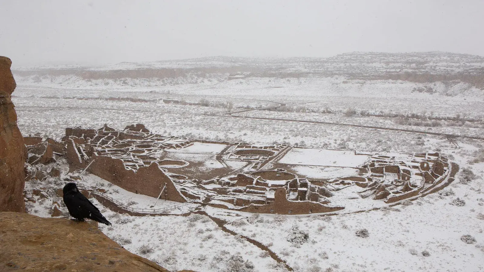
From the mid-800s, according to the Park Service, ancestral Pueblo people raised great houses in the canyon, a shallow cut through the high desert of the San Juan Basin. Pueblo Bonito, the largest, was D-shaped and stood four to five stories. The Park Service counts more than 600 rooms and 40 kivas, the round ceremonial rooms; Patricia Crown and W. Jeffrey Hurst of the University of New Mexico put the figure at about 800 rooms in a 2009 paper.
The Park Service’s answer to where the builders went begins with an exclamation: “Chacoan people did not suddenly vanish!” The people moved, in migrations south, east and west during the 1200s, and their descendants live in the pueblos of New Mexico and on the Hopi mesas. Pueblo descendants, the Park Service records, describe Chaco as a gathering place where clans met, and as a stop on their migration paths.
Where the timber came from
Nothing in the canyon could supply a roof beam. Christopher Guiterman, Thomas Swetnam and Jeffrey Dean of the University of Arizona’s tree-ring laboratory wrote in 2016 that ponderosa pine was scarce at the canyon’s elevation and spruce and fir had been absent for at least 12,000 years. Yet the great houses used an estimated 240,000 trees, a figure from a 1983 Park Service report that the service rounds to about 200,000. Primary roof beams averaged 15 feet long and weighed 187 to 309 pounds, wrote Stephen Nash of the Denver Museum of Nature and Science. The builders had no draft animals, no wheels and no navigable river.
Strontium isotope studies in 2001 and 2005 matched beams to the Chuska Mountains, 75 kilometers west, and Mount Taylor, 85 kilometers southeast. In 2016 Guiterman’s team matched the ring-width patterns of 170 beams from seven great houses to regional chronologies and found that 70 percent came from the Chuska and Zuni Mountains. Before 1020 nearly every beam came from the Zunis; by 1060 the Chuskas had overtaken them, in the same decades that Chuskan pottery became common in the canyon.
The roads that ran straight
The Park Service has mapped more than 400 miles of roads linking the canyon to more than 150 great houses. Inside the canyon the roads averaged about 15 feet wide; those heading out were about twice that, and some reached 30 feet. The best documented long road, the Great North Road, starts east of Pueblo Alto and runs north to Kutz Canyon.
Why a people without pack animals or carts needed a road 30 feet wide is the open question, and the Park Service presents both readings. Some archaeologists hold that the roads were symbolic or religious, and point to Zuni and Acoma pilgrimage trails that follow old road segments. Others hold that the roads also carried goods, since walking a surviving segment took less energy than crossing the ground beside it.
Reading the sky, and reading the rings
On Fajada Butte, at the canyon’s east entrance, three sandstone slabs lean against a wall carved with two spirals. In 1977 the artist Anna Sofaer found that at the summer solstice a sliver of light cut down through the center of the larger spiral, and at the winter solstice two slivers framed it; the slabs shifted in 1989. Casa Rinconada, a great kiva about 20 meters across, is often said to have a solstice window that lights a niche on the west wall. The High Altitude Observatory’s teaching pages list the problems: the walls were rebuilt after excavation, the window’s position is uncertain, and a roof post would have blocked the beam.
The dates came from the beams. Andrew Ellicott Douglass, an astronomer at the University of Arizona, spent 15 years matching ring patterns from living trees back through older beams. In December 1929 he published in National Geographic the dates for about 40 Southwestern sites; a charred beam fragment numbered HH-39, dug up near Show Low, Arizona, in June 1929, bridged the last gap in his sequence.
What the jars and the bones say
On what the buildings were for, the Park Service reports a split: many hold that the great houses were public buildings for ceremony and trade; others, that people lived in them. Its own estimate is a few thousand residents at the peak, with thousands more arriving for gatherings. In 2009 Crown and Hurst reported theobromine, the chemical marker of cacao, in three potsherds from the trash mounds south of Pueblo Bonito, dated by style to between 1000 and 1125. The sherds came from cylinder jars, tall vessels found almost only at Pueblo Bonito.
Room 33, a small crypt in the oldest part of Pueblo Bonito, held 14 burials and thousands of turquoise beads when an 1896 expedition opened it. In 2017 a team led by Douglas Kennett of Pennsylvania State University reported in Nature Communications that nine of them had identical mitochondrial DNA and that six included a mother and daughter and a grandmother and grandson: one maternal line, buried there from about 800 to 1130. Leigh Kuwanwisiwma, director of cultural preservation for the Hopi Tribe, told the writer Michael Balter that no one had informed the tribe, and Kurt Dongoske, the Pueblo of Zuni’s tribal historic preservation officer, described the American Museum of Natural History’s explanation for not consulting the tribes as “unacceptable.”
Why people moved on after 1130
Tree-ring dates show that great house construction stopped about 1130, and Benjamin Oswald, writing for World History Encyclopedia in 2018, placed that at the start of a 50-year drought in the San Juan Basin. The Park Service names no single cause. Its list runs from drought and depleted resources to social, religious or political change. Great house doors were sealed and great kivas burned, which Oswald described as a possible sign that the change was accepted in spiritual terms.
The beams answer the first question: ancestral Pueblo people cut them in the Zuni and Chuska Mountains and carried them across the basin for nearly three centuries. The second has the Park Service’s answer: the people moved, and did not vanish.
Key facts
- Chaco Canyon lies in the San Juan Basin of northwestern New Mexico; ancestral Pueblo people built its great houses from the mid-800s (National Park Service).
- Pueblo Bonito had more than 600 rooms and 40 kivas by the Park Service’s count, or about 800 rooms in Crown and Hurst’s 2009 estimate; tree rings date it to about 860–1128.
- An estimated 240,000 trees went into the great houses (Dean and Warren, 1983), a figure the Park Service rounds to about 200,000.
- Guiterman, Swetnam and Dean (2016) sourced 70 percent of 170 beams to the Chuska and Zuni Mountains, more than 75 kilometers away; the Chuskas overtook the Zunis about 1060.
- More than 400 miles of roads averaged 15 feet wide inside the canyon and up to 30 feet outside it; the Great North Road runs from Pueblo Alto to Kutz Canyon.
- Theobromine in three Pueblo Bonito sherds dated 1000–1125 is the first evidence of cacao north of the Mexican border (Crown and Hurst, 2009).
- Construction stopped about 1130; the 19 Pueblos of New Mexico and the Hopi claim Chaco as ancestral, and several Navajo clans are tied to its sites.
FAQ
Who built Chaco Canyon?
Ancestral Pueblo people built the great houses between the mid-800s and about 1130. The National Park Service records that the 19 Pueblo tribes of New Mexico and the Hopi of Arizona claim Chaco as their ancestral homeland, and that several Navajo clans tie their origins to Chacoan sites.
Where did the Chaco Canyon timber come from?
From the Chuska and Zuni Mountains, each more than 75 kilometers away, and from Mount Taylor, according to strontium studies in 2001 and 2005 and a 2016 tree-ring study of 170 beams. Before 1020 the Zuni Mountains supplied nearly all of it; by 1060 the Chuskas supplied more.
Why did people leave Chaco Canyon?
Building stopped about 1130 at the onset of a drought that World History Encyclopedia gives as 50 years long. The Park Service says the exact reasons are not known and lists drought, depleted resources and social or religious change among the possibilities; migrations south, east and west followed in the 1200s.
Sources
- National Park Service — Chaco Culture National Historical Park, "Frequently Asked Questions" (updated May 3, 2023).
- National Park Service — "New Mexico: Chaco Culture National Historical Park," travel itinerary article (updated August 7, 2017).
- National Park Service — Chaco Culture National Historical Park, "Chacoan Roads" (updated February 24, 2015).
- National Park Service — Chaco Culture National Historical Park, "History & Culture" (updated January 15, 2026).
- Christopher H. Guiterman, Thomas W. Swetnam and Jeffrey S. Dean — "Eleventh-century shift in timber procurement areas for the great houses of Chaco Canyon," PNAS 113(5) (2016), PMC open-access copy.
- Patricia L. Crown and W. Jeffrey Hurst — "Evidence of cacao use in the Prehispanic American Southwest," PNAS 106(7) (2009), PMC open-access copy.
- Douglas J. Kennett et al. — "Archaeogenomic evidence reveals prehistoric matrilineal dynasty," Nature Communications 8, 14115 (2017).
- SAPIENS — Michael Balter, "The Ethical Battle Over Ancient DNA" (March 30, 2017).
- SAPIENS — Stephen E. Nash, "The Astounding Origins of Chaco Canyon Timber."
- SAPIENS — Stephen E. Nash, "HH-39: Why Good Science Doesn't Need Eureka Moments."
- High Altitude Observatory (NCAR/UCAR) — "Casa Rinconada," Prehistoric Southwest teaching pages.
- PlanetQuest — "The Sun Dagger at Chaco Canyon."
- World History Encyclopedia — Benjamin Oswald, "Chaco Canyon" (June 29, 2018).
Cite this article
- APA
- Our Earth's History. (2026, September 20). Who carried 200,000 trees into Chaco Canyon, and why did they leave? Our Earth's History. https://ourearthshistory.com/americas/medieval/chaco-canyon-timber-roads-descendants/
- Chicago
- Our Earth's History. “Who carried 200,000 trees into Chaco Canyon, and why did they leave?” Our Earth's History, September 20, 2026. https://ourearthshistory.com/americas/medieval/chaco-canyon-timber-roads-descendants/.
- MLA
- “Who carried 200,000 trees into Chaco Canyon, and why did they leave?” Our Earth's History, 20 Sep. 2026, https://ourearthshistory.com/americas/medieval/chaco-canyon-timber-roads-descendants/.
Text licensed CC BY-NC-ND 4.0. Found an error? Tell us.