A midden fifteen feet high: Skara Brae from the storm of 1850 to 2017

TL;DR — A storm around 1850 uncovered Skara Brae in Orkney; Gordon Childe dug it from 1927 to 1930, and a 2017 Bayesian model dates its founding to about 2900 cal BC.
“About fifteen or sixteen years ago, the drift-sand . . . was undermined and swept away by the wild waves of the Atlantic, and an immense ‘Kitchen Midden’ . . . was exposed to view.” So George Petrie opened the paper he read to the Society of Antiquaries of Scotland in April 1867. The midden “was at some points 15 or 16 feet high,” and “The discovery was communicated to me by Mr William Watt, Skaill.” Watt owned the land at the Bay of Skaill, on the west coast of Orkney’s Mainland. Historic Environment Scotland (HES) dates the storm to 1850 and states that village life “seems to have ended around 2500 BC.” The houses are Neolithic; the men who dug them before Childe took them for the work of “the Pictish people.” A 2017 model built on 14 radiocarbon dates from a trench of 1972–73 puts the founding “in the centuries around 2900 cal BC.”
Quick facts
- When
- Storm around 1850 (Petrie, 1867; Historic Environment Scotland gives 1850) · 1861 (Farrer's partial examination) · April 1867 (Petrie's paper) · August 1913 (Balfour Stewart's clearance) · 1924 (guardianship) · 1925–26 (sea wall) · 1927–30 (Childe's campaigns) · 1972–73 (Clarke's trench 1) · 2017 (Bayesian remodeling) · 1999 (World Heritage inscription)
- Where
- Skara, Bay of Skaill, parish of Sandwick, west coast of Mainland, Orkney, off the north coast of Scotland
- Who
- William Watt of Skaill; George Petrie; W. Balfour Stewart; V. Gordon Childe and J. Wilson Paterson; David Clarke; Alex Bayliss, Peter Marshall, Colin Richards and Alasdair Whittle; Historic Environment Scotland
- Outcome
- A Neolithic village of stone houses with dressers, box-beds and hearths; Childe's reports numbered Huts 1 to 10; the 2017 model dates its founding to the centuries around 2900 cal BC, a reoccupation to the 28th century cal BC and a final abandonment of Orkney's villages to the 24th century cal BC
"Mr Farrer made a partial examination": 1861 to 1867
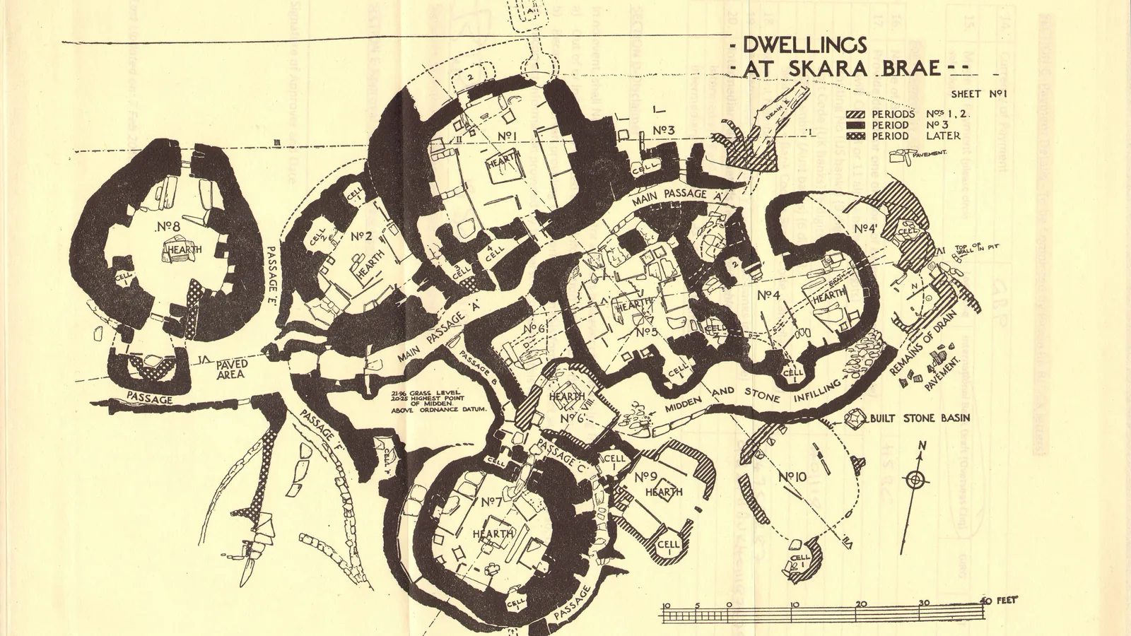
Petrie dated the first digging to 1861: “In 1861 Mr Farrer made a partial examination of the mound, and opened some chambers and passages.” Farrer’s newspaper account, quoted by Petrie, reported that “No human bones were found, but a stone vessel (probably a lamp)” had come out. “Mr Watt afterwards resumed the exploring of the mound, and by dint of great perseverance and labour, has succeeded in clearing out a large portion of the ruins,” Petrie wrote; he visited “repeatedly,” “taking care on each occasion to measure and plan the ruins.” His plan of 1867 was still the plan in use 46 years later.
August 1913: the principal dwelling and "the Pictish people"
W. Balfour Stewart reported to the Society in 1914: “During August 1913, while on a visit to Skaill . . . I commenced to clear the principal dwelling, and passage, which is shown on the plan, copied from that made by Mr Petrie in 1867.” Clay in the landward part of the houses was, for Stewart, proof of “Mr Petrie’s view that, on opening the landward portion of the dwellings, clay would be found brought there by the Pictish people to plaster or bind their walls.” Dorothy N. Marshall, cataloging carved stone balls in 1979, glossed Ludovic Mann’s paper of 1914: “(when he wrote it was considered that the balls were Pictish in origin).”
Childe and Paterson: a sea wall first, then trenches, 1927 to 1930
V. Gordon Childe and J. Wilson Paterson, in their provisional report of 1929, recorded that the site “was placed under the guardianship of H.M. Commissioners of Works in 1924 by the trustees of W. G. Thomas Watt, and steps were taken to arrest the encroachment of the sea.” A sea wall came first: “The erection of the sea-wall occupied the greater part of the summers 1925-26, and it was not until 1927 that it was possible, for financial reasons, to attempt to preserve the actual buildings.” Paterson led the 1927 season, down to “the floor-level previously bared by George Petrie”; the reports numbered the houses Hut 1 to Hut 10. In 1928 “yet another small cell was discovered,” and in it lay “one carved stone ball with six projecting knobs.”
Childe’s final report of 1931, with D. M. S. Watson and A. Robinson, followed “drain C” through Hut 4 and “drain B” from the cell in Hut 5, and a doorway “pierced with a hole for the bar.” It sorted the buildings into periods, “an earlier epoch of building, which may be termed period II,” and left a question in the text: “Is Hut 7 a survival from period II?” On the village’s age the 1929 report was plain. “It is frankly difficult to understand how, if Skara was partly contemporary with the brochs that stand so near it, not a trace of distinctive broch types and metal has been found in the village,” Childe and Paterson wrote. “That phase is either prior to or posterior to the regular broch period, but we cannot certainly say which.”
Dressers, box-beds and a hearth in each room
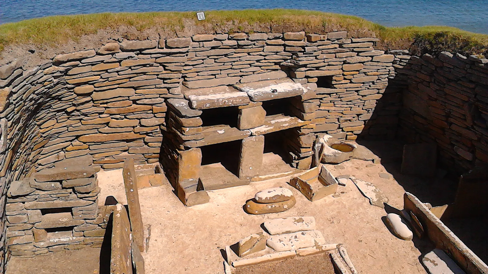
HES describes the houses as “well built of flat stone slabs, set into large mounds of midden, linked by covered passageways,” each a single room of “roughly 40sq m,” and lists what each held: “‘Fitted’ stone furniture in each room includes: a ‘dresser’ – perhaps to store and display special objects; two box-beds; a central hearth; small tanks set into the floor – possibly for preparing fish bait.” One differs: “A larger structure at one end of the village has a special hearth and no box-beds, so may have been a workshop.” “No weapons have been found and the village was not in a readily defended location, both of which suggest a peaceful life.” Marshall’s catalogue of 1979 counted “four of the balls come from Orkney, three from Skara Brae,” and placed them “in the later neolithic period.” On the end of the village HES gives two readings, a huge sandstorm burying the houses or “a more gradual process,” and chooses neither.

Fourteen radiocarbon dates, and a village founded around 2900 cal BC
The dates came from trench 1, dug in 1972–73 under David Clarke; Alex Bayliss and her co-authors cite the list as Renfrew and Buteux 1985 and add that it “formed the basis of one of the first case studies for the application of a Bayesian approach to interpreting chronology in archaeology (Buck et al. 1991).” Bayliss, Peter Marshall, Colin Richards and Alasdair Whittle remodeled them in Antiquity in 2017 with dates from across Orkney, under a pottery name, Grooved Ware, absent from Childe’s reports. Their timescape: “A similar scenario occurred at Skara Brae, where an earlier nucleated settlement with recessed house architecture, founded in the centuries around 2900 cal BC, may have been abandoned after a relatively short period of habitation, and re-occupied in the twenty-eighth century cal BC.” The model closes with “a final abandonment of villages in the twenty-fourth century cal BC.”
In 1999 Skara Brae became part of the World Heritage Site that HES names the Heart of Neolithic Orkney, with Maeshowe Chambered Cairn, the Ring of Brodgar Stone Circle and Henge and the Stones of Stenness Circle and Henge; digs at Links of Noltland on Westray and at the Ness of Brodgar, HES states, “are now revealing other settlements of a similar period to Skara Brae.” The mound Petrie measured in 1867 is, in the 2017 model, a village founded around 2900 cal BC and given up with the rest of Orkney’s villages in the 24th century cal BC.
Key facts
- George Petrie’s paper of April 1867 dated the exposure of the “Kitchen Midden” to “fifteen or sixteen years ago” and named “Mr William Watt, Skaill” as the man who told him; Historic Environment Scotland gives the storm year as 1850 (Petrie 1867; HES).
- “In 1861 Mr Farrer made a partial examination of the mound”; Watt then cleared “a large portion of the ruins,” and Petrie measured “on each occasion” (Petrie 1867).
- W. Balfour Stewart cleared “the principal dwelling, and passage” in August 1913 and wrote of clay “brought there by the Pictish people” (Balfour Stewart 1914).
- The site “was placed under the guardianship of H.M. Commissioners of Works in 1924”; the sea wall took “the greater part of the summers 1925-26,” and digging began in 1927 (Childe and Paterson 1929).
- In 1928 a small cell yielded “one carved stone ball with six projecting knobs”; Marshall’s catalogue of 1979 counts three balls from Skara Brae, “later neolithic period” (Childe and Paterson 1929; Marshall 1979).
- Childe’s final report of 1931 records drains B and C, a doorway “pierced with a hole for the bar,” period II, and the question “Is Hut 7 a survival from period II?” (Childe 1931).
- Each house has “a ‘dresser’ . . . two box-beds; a central hearth; small tanks set into the floor,” a floor of “roughly 40sq m,” and “No weapons have been found” (HES).
- Bayliss, Marshall, Richards and Whittle (2017) date the founding to “the centuries around 2900 cal BC,” a reoccupation to “the twenty-eighth century cal BC” and the final abandonment of villages to “the twenty-fourth century cal BC”; Skara Brae joined the Heart of Neolithic Orkney World Heritage Site in 1999 (Antiquity 2017; HES).
FAQ
Who discovered Skara Brae and when?
A storm exposed the midden about 1850, and the landowner, William Watt of Skaill, reported it to George Petrie, who read a paper on the ruins to the Society of Antiquaries of Scotland in April 1867. Petrie also recorded a partial examination by Mr Farrer in 1861.
How old is Skara Brae?
Historic Environment Scotland states that village life "seems to have ended around 2500 BC." The Bayesian model of Bayliss, Marshall, Richards and Whittle (2017) dates the founding of the first nucleated settlement to "the centuries around 2900 cal BC," with a reoccupation in the 28th century cal BC and a final abandonment of Orkney's villages in the 24th century cal BC.
What furniture was found inside the houses at Skara Brae?
Historic Environment Scotland lists a stone "dresser," two box-beds, a central hearth and small tanks set into the floor in each single-room house of roughly 40 square meters. A larger structure with a special hearth and no beds may have been a workshop.
Sources
- George Petrie, "Notice of Ruins of Ancient Dwellings at Skara, Bay of Skaill, in the Parish of Sandwick, Orkney, recently excavated," Proceedings of the Society of Antiquaries of Scotland, vol. VII (1866–68), pp. 201–219, read April 1867 (the storm, Watt, Farrer's 1861 dig, the winding passage).
- W. Balfour Stewart, with notes by W. Boyd Dawkins, "Notes on a Further Excavation of Ancient Dwellings at Skara, in the Parish of Sandwick, Orkney, made during August 1913," Proceedings of the Society of Antiquaries of Scotland, vol. XLVIII (1913–14), pp. 344–355 (the 1913 clearance, "the Pictish people").
- V. Gordon Childe and J. Wilson Paterson, "Provisional Report on the Excavations at Skara Brae, and on Finds from the 1927 and 1928 Campaigns," Proceedings of the Society of Antiquaries of Scotland, vol. LXIII (1928–29), pp. 225–280 (guardianship of 1924, the sea wall of 1925–26, the 1928 cell and its stone ball, the brochs).
- V. Gordon Childe, D. M. S. Watson and A. Robinson, "Final Report on the Operations at Skara Brae," Proceedings of the Society of Antiquaries of Scotland, vol. LXV (1930–31), pp. 27–77 (Huts 1 to 10, drains B and C, the bar-hole, period II, Hut 7).
- Dorothy N. Marshall, "Carved Stone Balls," Proceedings of the Society of Antiquaries of Scotland, vol. 108 (1976–77), pp. 40–72, published 1979 (three balls from Skara Brae, museum numbers, "later neolithic period," Mann in 1914).
- Alex Bayliss, Peter Marshall, Colin Richards and Alasdair Whittle, "Islands of history: the Late Neolithic timescape of Orkney," Antiquity, vol. 91, issue 359 (Cambridge University Press, online September 20, 2017), open access (the 14 dates from trench 1, the Bayesian case study of 1991, Grooved Ware, the founding around 2900 cal BC and the abandonments).
- Historic Environment Scotland, "Skara Brae," visitor page ("First uncovered by a storm in 1850," nine surviving Neolithic dwellings, the Heart of Neolithic Orkney).
- Historic Environment Scotland, "History and stories, Skara Brae" (the houses and their furniture, the larger structure, the absence of weapons, the end of village life around 2500 BC, the 1999 inscription, Links of Noltland and the Ness of Brodgar).
Cite this article
- APA
- Our Earth's History. (2026, September 22). A midden fifteen feet high: Skara Brae from the storm of 1850 to 2017. Our Earth's History. https://ourearthshistory.com/europe/prehistory/skara-brae-orkney-1850-storm-petrie-1867-childe-1927-bayliss-2017/
- Chicago
- Our Earth's History. “A midden fifteen feet high: Skara Brae from the storm of 1850 to 2017.” Our Earth's History, September 22, 2026. https://ourearthshistory.com/europe/prehistory/skara-brae-orkney-1850-storm-petrie-1867-childe-1927-bayliss-2017/.
- MLA
- “A midden fifteen feet high: Skara Brae from the storm of 1850 to 2017.” Our Earth's History, 22 Sep. 2026, https://ourearthshistory.com/europe/prehistory/skara-brae-orkney-1850-storm-petrie-1867-childe-1927-bayliss-2017/.
Text licensed CC BY-NC-ND 4.0. Found an error? Tell us.