Footprints on a Norfolk beach, May 2013: the Happisburgh prints

TL;DR — Footprints were exposed at Happisburgh, Norfolk, in May 2013; tides erased them within weeks, and Ashton’s team dated the surface to 1 million to 780,000 years ago.
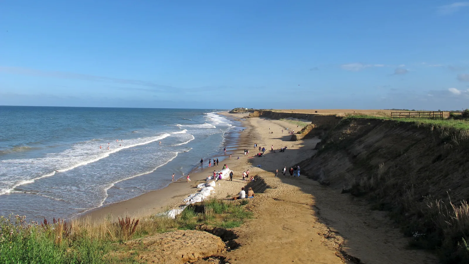
“In early May 2013 an area of laminated silts was exposed” at Happisburgh, on the Norfolk coast, wrote Nick Ashton and ten co-authors in PLOS ONE. By the end of the month the surface “had been completely removed” by the tide. The paper’s abstract called it “the oldest known hominin footprint surface outside Africa at between ca. 1 million and 0.78 million years ago.” Over two weeks the team recorded about 12 square meters of the surface with multi-image photogrammetry and laser scanning before the sea took it apart. Of 152 hollows measured, 12 had outlines clear enough for analysis, and the paper concluded they belonged to a group of at least five adults and juveniles. The same stretch of coast, at a spot the team calls Site 3, had already produced flint tools that Simon A. Parfitt and fifteen co-authors dated to more than 780,000 years in Nature in 2010.
Quick facts
- When
- Early May 2013 (surface exposed and recorded); removed by tidal erosion by the end of May 2013; July 8, 2010 (Nature paper on Site 3 flint tools); February 7, 2014 (PLOS ONE paper on the footprints)
- Where
- Area A and Site 3, Happisburgh, on the Norfolk coast, England
- Who
- Nick Ashton (British Museum and UCL) and ten co-authors; Simon A. Parfitt and fifteen co-authors; Chris Stringer; the Natural History Museum, London; Queen Mary University of London; the Ancient Human Occupation of Britain project
- Outcome
- A photogrammetry and laser-scan record of 152 hollows, 12 analyzed as footprints, before the tide removed the surface; the paper dated it to between about 1 million and 780,000 years ago, the oldest known hominin footprint surface outside Africa
May 2013, and a surface exposed at Area A
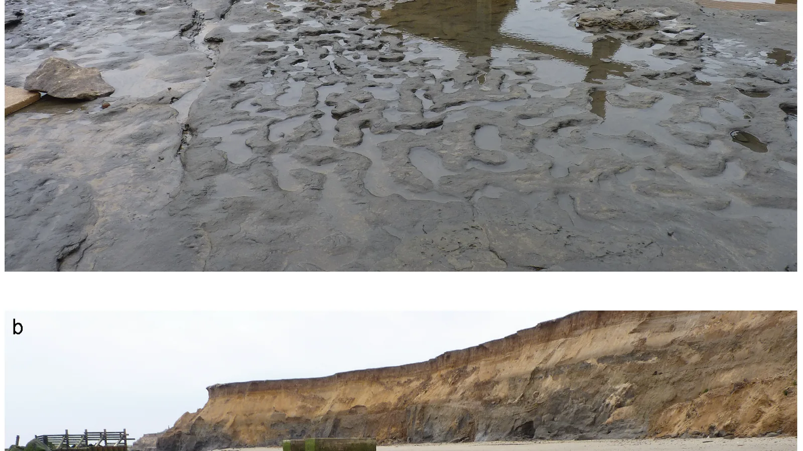
The exposed surface lay in Area A, “approximately 100 m north west of the location of borehole HC,” Ashton’s team wrote. It sat within the Hill House Formation, estuarine sediments that the paper dated to the Early Pleistocene, “between 1 and 0.78 My.” The hollows themselves were shallow, “generally 30-50 mm in depth, 140-250 mm in length and 60-110 mm in width,” spread across roughly 12 square meters of the formation’s surface. Over the following two weeks the team used multi-image photogrammetry, a technique the paper described as “digital photographs taken from multiple positions around and above a subject, which are then processed to produce a 3D record of the surface,” together with laser scanning. Erosion took the surface apart tidal cycle by tidal cycle, and “the features became less distinct as a result of erosion over successive tidal cycles” until “they had been completely removed by the end of May 2013.”
Nick Ashton's team and a count of hollows
Ashton’s team measured 152 hollows in total, finding that their lengths and widths had “means and standard deviations of 172±60 and 80±27 mm respectively.” Quantitative analysis of footprint dimensions, the paper said, “was limited to 12 prints where complete outlines could be . . . identified,” with lengths that “vary from ca. 140 to 260 mm, indicating that they were made by several people of different ages.” Accounting for slippage and erosion, the paper wrote, “the lengths possibly indicate five individuals.” Stature estimates from those twelve prints, using a standard ratio of foot length to height, gave “a height range between 0.93 and 1.73 m, suggesting the presence of adults and children.” For three prints longer than 230 millimeters, the team estimated body mass at “ca. 48 to 53 kg using the regression based on footprint area or ca. 48 to 52 kg using the regression based on footprint length,” a figure the paper said “should be treated with caution.”
.png)
Direction, and a group of at least five
Direction data from 49 of the hollows showed “a distinct preferred south-north orientation,” and 29 of those preserved enough detail to distinguish front from back, giving “a preferred direction of movement to the south.” Taken together, Ashton’s team concluded, the evidence pointed to “a group of at least five adults and juveniles walking along the mudflats of a large river.”
"The only known species in western Europe of a similar age"
“The only known species in western Europe of a similar age is Homo antecessor, whose fossil remains have been found at Atapuerca, Spain,” the PLOS ONE paper stated, adding that the foot sizes and estimated statures at Happisburgh “fall within the range” of that fossil evidence. The Natural History Museum’s page on the project, “Pioneering populations,” puts the tallest individual at “about 1.7 metres (5 feet 8 inches) in height,” a figure it calls consistent with skeletal evidence “of the average male Homo antecessor from the broadly contemporaneous site of Atapuerca in northern Spain.” The same page places the footprints “just to the south of” Site 3, which it dates to “approximately 900,000 years old” and calls “the oldest archaeological site in northern Europe,” notable for “excellent organic preservation of beetle, plant and mammal remains.” The museum lists five principal sites at Happisburgh, with current work concentrated on Site 1, dated to about 500,000 years and known for handaxes, Site 3, and Site 5, a submerged prospect that a University of Southampton dive team surveyed between 2012 and 2015.
Seventy flint tools, and the AHOB project
More than 70 flint tools had already come from Site 3, Queen Mary University of London reported in a news release when Simon A. Parfitt, Nick Ashton, Simon G. Lewis and thirteen co-authors published their find in Nature on July 8, 2010, describing “over 70 flint tools and flakes excavated on the foreshore at Happisburgh, Norfolk.” The Nature abstract stated that the site showed “Early Pleistocene hominins were present in northern Europe >0.78 Myr ago when they were able to survive at the southern edge of the boreal zone,” a claim set against an earlier find at Pakefield, Suffolk, where the evidence had indicated occupation “at ∼0.7 Myr” under “a Mediterranean-type climate.” Simon Lewis, who had worked the excavation since 2005, told Queen Mary that the find “extends the record of human presence in Britain back by at least 100,000 years.” Simon Parfitt, then at University College London, described the setting to the university: “The flood plain would have been dominated by grass, supporting a diverse range of herbivores, such as mammoth, rhino and horse. Predators would have included hyaenas, sabre-toothed cats and . . . humans.” The excavation was funded by the British Museum as part of the Ancient Human Occupation of Britain project, which the project’s own website describes as running “from 2001 through 2011 with funding from the Leverhulme Trust,” succeeded by the Calleva Foundation-funded Pathways to Ancient Britain project that recorded the footprints three years later. The PLOS ONE paper on those footprints was published on February 7, 2014.
Key facts
- In early May 2013, an area of laminated silt was exposed at Area A, Happisburgh, and by the end of the month tidal erosion had “completely removed” the surface (Ashton et al., PLOS ONE, 2014).
- Ashton’s team measured 152 hollows across about 12 square meters and recorded them over two weeks with multi-image photogrammetry and laser scanning (same paper).
- Quantitative analysis was limited to 12 hollows with complete outlines, with lengths from 140 to 260 millimeters and estimated statures between 0.93 and 1.73 meters (same paper).
- The paper dated the footprint surface to “between ca. 1 million and 0.78 million years ago,” the oldest known hominin footprint surface outside Africa (same paper).
- The paper attributed the footprints to “a group of at least five adults and juveniles” and, by elimination among known European fossils, to Homo antecessor, whose remains come from Atapuerca, Spain (same paper).
- In 2010, Simon A. Parfitt and fifteen co-authors reported more than 70 flint tools from Site 3 in Nature, dated to more than 780,000 years (Parfitt et al., Nature, 2010; Queen Mary University of London news release).
- The Natural History Museum’s “Pioneering populations” page gives Site 3 as “approximately 900,000 years old” and the tallest footprint-maker as about 1.7 meters tall.
- The excavation at Site 3 was funded by the British Museum as part of the Ancient Human Occupation of Britain project (2001-2011, Leverhulme Trust), continued by the Calleva Foundation-funded Pathways to Ancient Britain project, and the PLOS ONE paper appeared on February 7, 2014.
FAQ
How old are the Happisburgh footprints?
Nick Ashton and his co-authors dated the surface in PLOS ONE to "between ca. 1 million and 0.78 million years ago." The Natural History Museum gives the nearby Site 3, with its flint tools, as "approximately 900,000 years old."
Who made the footprints at Happisburgh?
The PLOS ONE paper attributed them to a group of "at least five adults and juveniles" and identified Homo antecessor, known from fossils at Atapuerca, Spain, as "the only known species in western Europe of a similar age."
Why do the Happisburgh footprints no longer exist?
Tidal erosion took the surface apart over successive cycles in May 2013, and "they had been completely removed by the end of May 2013," according to the 2014 paper, which is why the team recorded the surface with photogrammetry and laser scanning in the two weeks before it disappeared.
Sources
- Nick Ashton, Simon G. Lewis, Isabelle De Groote, Sarah M. Duffy, Martin Bates, Richard Bates, Peter Hoare, Mark Lewis, Simon A. Parfitt, Sylvia Peglar, Craig Williams and Chris Stringer, "Hominin Footprints from Early Pleistocene Deposits at Happisburgh, UK," PLOS ONE 9(2): e88329, published February 7, 2014.
- Simon A. Parfitt, Nick M. Ashton, Simon G. Lewis, Richard L. Abel, G. Russell Coope, Mike H. Field, Rowena Gale, Peter G. Hoare, Nigel R. Larkin, Mark D. Lewis, Vassil Karloukovski, Barbara A. Maher, Sylvia M. Peglar, Richard C. Preece, John E. Whittaker and Chris B. Stringer, "Early Pleistocene human occupation at the edge of the boreal zone in northwest Europe," Nature 466, pp. 229-233, published online July 8, 2010 (abstract).
- Natural History Museum, London, "Pioneering populations," Pathways to Ancient Britain project page.
- Queen Mary University of London, News, "The first arrivals - ancient Britons were the earliest North Europeans," published July 8, 2010.
- Ancient Human Occupation of Britain (AHOB) project website.
Cite this article
- APA
- LETTER. (2026, September 28). Footprints on a Norfolk beach, May 2013: the Happisburgh prints. Our Earth's History. https://ourearthshistory.com/europe/prehistory/happisburgh-footprints-may-2013-norfolk-hill-house-formation/
- Chicago
- LETTER. “Footprints on a Norfolk beach, May 2013: the Happisburgh prints.” Our Earth's History, September 28, 2026. https://ourearthshistory.com/europe/prehistory/happisburgh-footprints-may-2013-norfolk-hill-house-formation/.
- MLA
- LETTER. “Footprints on a Norfolk beach, May 2013: the Happisburgh prints.” Our Earth's History, 28 Sep. 2026, https://ourearthshistory.com/europe/prehistory/happisburgh-footprints-may-2013-norfolk-hill-house-formation/.
Text licensed CC BY-NC-ND 4.0. Found an error? Tell us.