How did the Nazca draw figures they could never see whole?
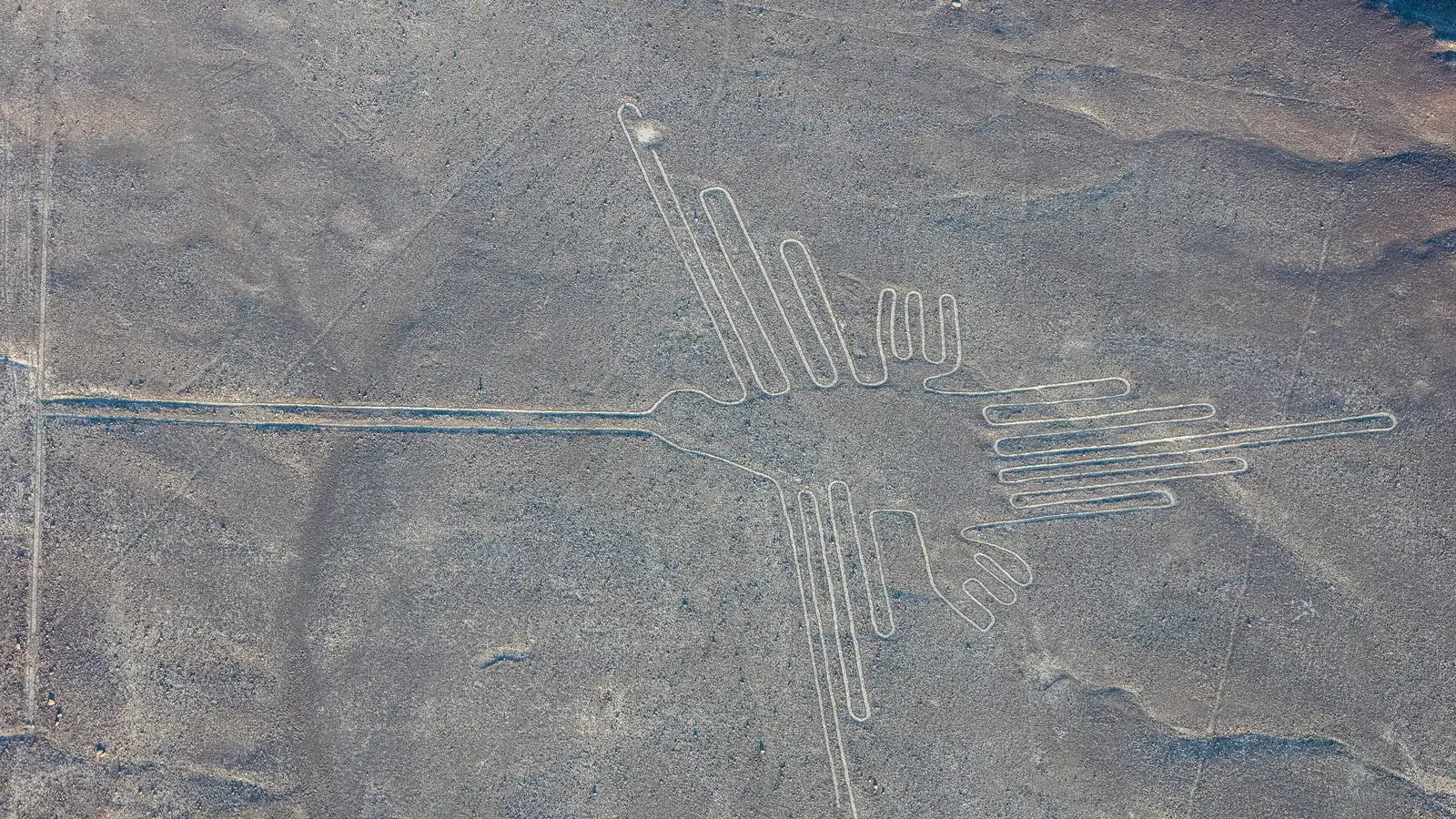

TL;DR — Workers cleared dark stones off the desert to expose pale ground, enlarging small designs; almost no rain fell, so the marks stayed put for about 2,000 years.
The Nazca made their giant figures by clearing dark stones off the desert floor to expose pale ground, scaling up small designs like those on their pottery. The lines lie on a desert tableland about 400 kilometers south of Lima in southern Peru, and UNESCO, which listed the site in 1994, dated them to between 500 BC and AD 500. A figure did not have to be seen whole to do its work: Johan Reinhard and Anthony Aveni read the lines as paths and plazas for rites that asked for water, and a 2024 survey led by Masato Sakai of Yamagata University found the smaller figures beside footpaths, in view of anyone walking past. Rain almost never falls on the pampa, which is why the shallow cuts have lasted two millennia.
Quick facts
- When
- About 100 BC–AD 650 (Nasca period) · rediscovered in the 1920s · Paul Kosok's solstice sunset June 22, 1941 · UNESCO listing 1994 · Greenpeace protest December 8, 2014 · AI survey 2022–23, published September 2024
- Where
- The Nazca Pampa in the Rio Grande de Nasca basin, about 400 kilometers south of Lima, southern Peru
- Who
- The Nasca people; Toribio Mejía Xesspe, Paul Kosok and Maria Reiche (early study); Johan Reinhard and Anthony Aveni (water and ritual); Masato Sakai of Yamagata University with IBM Research (2024 survey)
- Outcome
- Dark stones cleared by hand to expose pale ground; about 50 giant animal figures and, after 2024, 683 small relief figures documented; the site is a UNESCO World Heritage property
What the lines are and where they lie
The Nazca Pampa is a plateau between the Ingenio and Nazca river valleys, about 50 kilometers inland from the Pacific, according to the 2024 paper by Sakai and his colleagues in the Proceedings of the National Academy of Sciences (PNAS). UNESCO’s listing put the geoglyphs at about 450 square kilometers and sorted them into pictures (birds, a monkey, a spider, a killer whale, plants) and lines, some several kilometers long, forming triangles, spirals and trapezoids. The pictures come in two sizes: Sakai’s team counted 50 line-type figures, each a single outline averaging 90 meters long, and 683 relief-type figures averaging nine meters, many on hill slopes where they could be seen from a distance.
How they were made and why they survived
The desert surface is a bed of stones that oxidized and weathered to a rust color. National Geographic’s Jason Golomb described the method: remove the top 12 to 15 inches (30 to 38 centimeters) of stone, and light-colored sand shows through. Joseph McAuliffe of the Arizona-Sonora Desert Museum told National Geographic in 2014 that the dark coating on each stone, called desert varnish, is only about as thick as a sheet of paper. The removed stones were piled along the edges, Sakai’s team recorded.
The marks lasted because nothing disturbed them. UNESCO’s evaluation recorded the lowest rainfall rates in the world, with running water only in El Niño years, and the PNAS paper added that the pampa was not easily flooded and unfit for farming.
Who made them and when
Pottery sherds scattered on and beside the geoglyphs date their use. Sakai’s team wrote that people used geoglyphs on the pampa from at least the first century BC and kept using them until the fifteenth century AD, and that the large animal figures belong to the Nasca period, about 100 BC to AD 650; Early Nasca pottery (AD 50 to 300) turned up at the “whale” and “monkey” figures.
Toribio Mejía Xesspe, a Peruvian archaeologist, was the first to study the lines systematically, in the 1920s. On June 22, 1941, the American professor Paul Kosok stood at the foot of a line the day after the June solstice and watched the sun set along it; he called the pampa “the largest astronomy book in the world,” according to Golomb. Maria Reiche, a German mathematician, then studied the lines for 40 years.
How a figure took shape at ground level
From the ground, Golomb wrote, the large figures are almost impossible to make out. The people who drew them did not need to see them. Mark Cartwright wrote in World History Encyclopedia in 2014 that a design was enlarged in careful proportion from a small model, and that many of the same designs appear on Nasca textiles and pottery. Each outline figure is one continuous line that never crosses itself and has separate start and end points, which Cartwright took as evidence that the line was meant to be walked. Cartwright wrote that the idea of visitors from another world is dismissed for lack of evidence and because the work was easy: stones moved by hand, in designs the Nazca already painted on their pots, and one experiment he cited had a small team clear 16,000 square meters in a week.
Astronomy or water: what the lines were for
Kosok and Reiche read the lines as a calendar and star map, and that reading held until the 1970s. Reinhard, a National Geographic explorer-in-residence, wrote in his book The Nasca Lines: A New Perspective on their Origin and Meanings: “It seems likely that most of the lines did not point at anything on the geographical or celestial horizon, but rather led to places where rituals were performed to obtain water and fertility of crops.” Aveni told National Geographic that the trapezoids were wide open spaces where people could come in and out, and that the rites there probably pleaded for water.
The PNAS survey gave that reading a map. The 50 large animal figures sit an average of 34 meters from the network of lines and trapezoids in use during the Early Nasca period, when the temple center of Cahuachi was at its height, and the team read the trapezoids as ritual squares on a pilgrimage route from the Ingenio valley to Cahuachi.
The 2024 AI survey and the 2014 footprints
Between September 2022 and February 2023, Sakai’s team walked the pampa with a target list from an IBM Research model trained on a few hundred known figures, and confirmed 303 new figurative geoglyphs, against 430 found in the previous century. Of the small relief figures now known, 81.6 percent show humanoids, decapitated heads or domesticated llamas, and they lie an average of 43 meters from the winding trails. These, the team wrote, were made to be seen from the trails by individuals or small groups, while the giant outlines belonged to community rites.
On December 8, 2014, during the United Nations climate conference in Lima, Greenpeace activists entered the restricted zone and laid yellow letters reading “Time for change! The future is renewable” beside the hummingbird figure. Luis Jaime Castillo, Peru’s deputy culture minister, told the Associated Press that a footprint there would last hundreds or thousands of years. Greenpeace apologized two days later; Peru said it would seek criminal charges. The same thin crust that held a design for two millennia held the footprints too.
The Nazca never saw their birds and whales from the air, and the evidence suggests they had no need to. Small designs were scaled up on the ground, stones were moved by hand, and the figures were walked or looked at from a trail. The desert did the rest.
Key facts
- The geoglyphs lie on the Nazca Pampa, about 400 kilometers south of Lima; UNESCO listed the site in 1994 at about 450 square kilometers.
- Makers cleared the rust-colored surface stones to expose pale sand; the dark coating is about as thick as a sheet of paper (National Geographic, 2014).
- Pottery on the geoglyphs dates their use from at least 100 BC to the fifteenth century AD; the large animal figures belong to the Nasca period, about 100 BC to AD 650 (Sakai et al., 2024).
- Paul Kosok saw the sun set along a line on June 22, 1941; Maria Reiche then studied the lines for 40 years.
- Johan Reinhard and Anthony Aveni read the lines and trapezoids as paths and plazas for water rites, not as a star chart.
- The 2022–23 AI-assisted survey found 303 new figures in six months, nearly doubling the 430 known; 81.6 percent of small relief figures show humans, heads or llamas.
- On December 8, 2014, Greenpeace activists left footprints beside the hummingbird; Greenpeace apologized and Peru said it would seek criminal charges.
FAQ
How were the Nazca Lines made?
By clearing the dark, oxidized stones off the desert surface to expose the lighter sand beneath, to a depth of about 12 to 15 inches according to National Geographic. Removed stones were piled along the edges.
Why have the Nazca Lines lasted so long?
The pampa has some of the lowest rainfall on Earth, sees running water only in El Niño years, and was never flooded or farmed, so the cleared marks were never covered or washed out.
What were the Nazca Lines for?
Kosok and Reiche read them as a calendar. Reinhard and Aveni argued they were paths and plazas for rites that asked for water, and the 2024 survey by Yamagata University and IBM Research found the giant figures on a ritual network and the small ones beside walking trails.
Sources
- UNESCO World Heritage Centre — "Lines and Geoglyphs of Nasca and Palpa," World Heritage List entry 700 (inscribed 1994).
- Yamagata University — press release, "AI-accelerated Nazca survey nearly doubles the number of known figurative geoglyphs and sheds light on their purpose" (September 24, 2024).
- Masato Sakai et al. — "AI-accelerated Nazca survey nearly doubles the number of known figurative geoglyphs and sheds light on their purpose," PNAS 121(40), e2407652121 (September 23, 2024), PDF via the DLR repository.
- National Geographic — Jason Golomb, "Why the Nasca lines are among Peru's greatest mysteries."
- World History Encyclopedia — Mark Cartwright, "Nazca Lines" (March 10, 2014).
- Smithsonian Magazine — Meilan Solly, "Scientists Identify Exotic Birds Depicted in Peru's Mysterious Nazca Lines" (June 21, 2019).
- National Geographic — Dan Vergano, "Mystery Surrounds Delicate Nasca Lines Threatened by Greenpeace Stunt" (December 13, 2014).
- NPR — Sam Sanders, "Greenpeace Apologizes For Stunt At Peru's Sacred Nazca Lines" (December 11, 2014).
Cite this article
- APA
- Our Earth's History. (2026, September 19). How did the Nazca draw figures they could never see whole? Our Earth's History. https://ourearthshistory.com/americas/classical/nazca-lines-how-drawn-and-why/
- Chicago
- Our Earth's History. “How did the Nazca draw figures they could never see whole?” Our Earth's History, September 19, 2026. https://ourearthshistory.com/americas/classical/nazca-lines-how-drawn-and-why/.
- MLA
- “How did the Nazca draw figures they could never see whole?” Our Earth's History, 19 Sep. 2026, https://ourearthshistory.com/americas/classical/nazca-lines-how-drawn-and-why/.
Text licensed CC BY-NC-ND 4.0. Found an error? Tell us.