A stone tower at Jericho, 8.2 meters tall, still disputed

TL;DR — Kenyon found an 8.2-meter stone tower inside Jericho’s Neolithic wall; Bar-Yosef, Barkai and Liran, and Naveh each gave a different explanation for it.
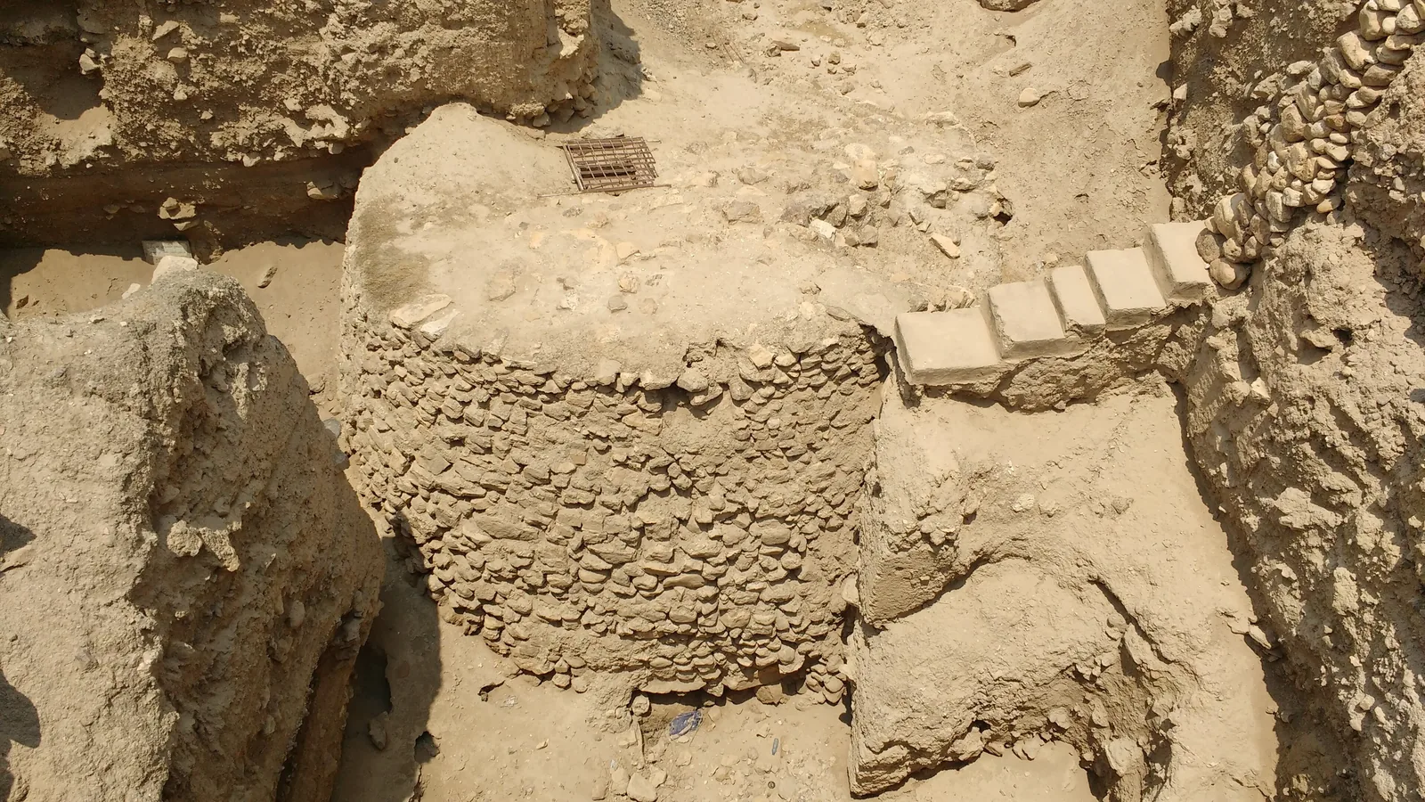
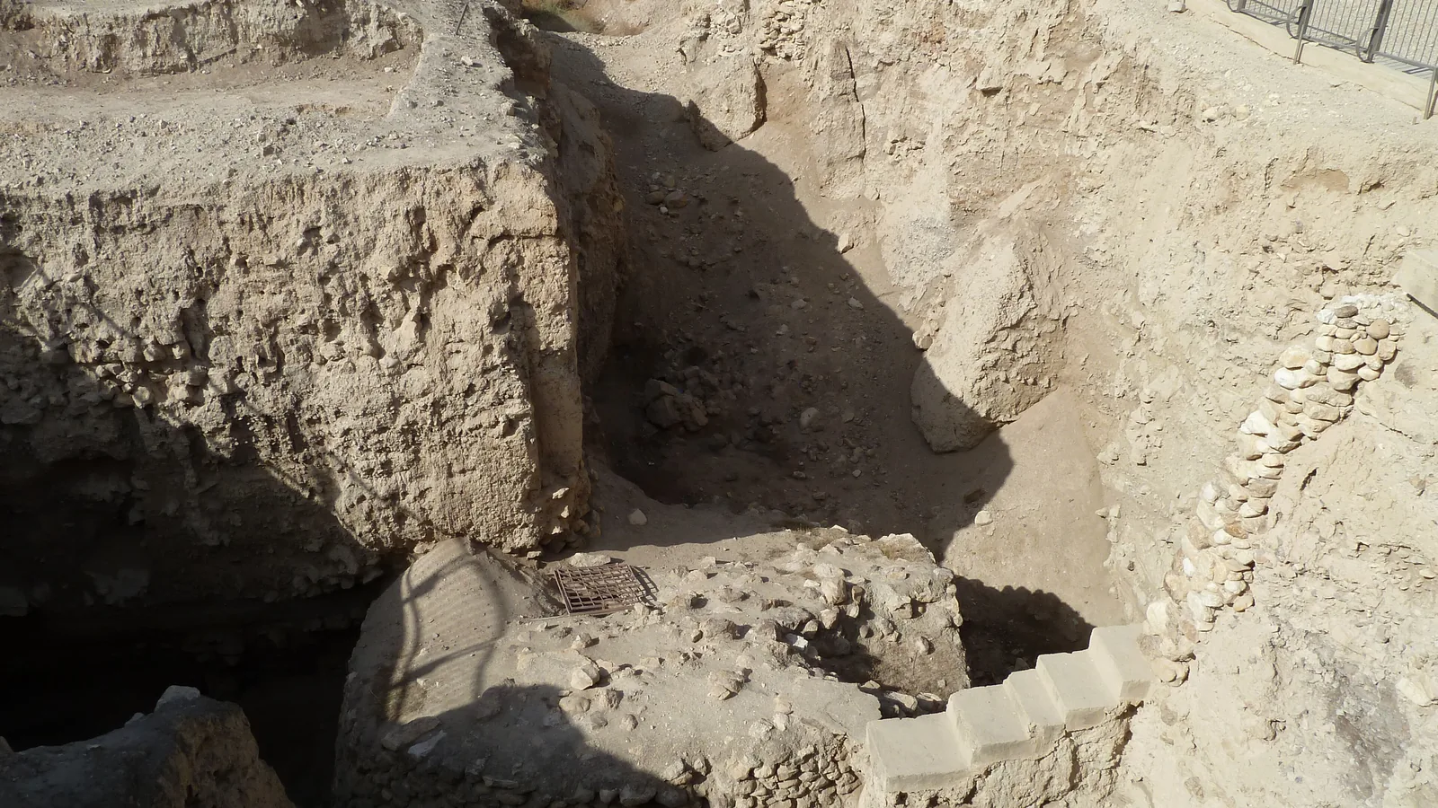
Ofer Bar-Yosef, in a 1986 paper in Current Anthropology, described what Kathleen Kenyon’s excavation had uncovered at Jericho: “The tower, placed inside the perimeter of the settlement, was 8.2 m high (ca. 9 m in diameter at the base and 7 m at the top) and built of undressed stones. It had a staircase leading to the top with 22 steps built of dressed slabs.” Radiocarbon dates published in the same paper place its construction between 8300 and 7800 BC. The tower still stands at Tell es-Sultan, the mound at Jericho.
Quick facts
- When
- Excavated 1952 to 1958; radiocarbon dates place construction between 8300 and 7800 BC and abandonment around 7400 to 7300 BC; World Heritage inscription September 17, 2023
- Where
- Tell es-Sultan, the mound at Jericho, in the West Bank
- Who
- Kathleen Kenyon (British School of Archaeology in Jerusalem); Ofer Bar-Yosef (Hebrew University of Jerusalem); Ran Barkai and Roy Liran (Tel Aviv University); Danny Naveh; the Palestinian Ministry of Tourism and Antiquities and Sapienza University of Rome
- Outcome
- Kenyon's team uncovered a conical stone tower inside the settlement's perimeter wall. Kenyon read it as defensive; later researchers proposed a flood barrier and ritual center, a summer-solstice shadow marker, and a display of inter-group and intra-group power. No reading has been agreed on
Kathleen Kenyon, 1952 to 1958
Kenyon dug at Tell es-Sultan for the British School of Archaeology in Jerusalem from 1952 to 1958. Bar-Yosef’s paper places her work in a sequence: “The Germans E. Sellin and C. Watzinger dug a series of trenches between 1907 and 1909, and they were followed by J. Garstang, 1930-36, and K. Kenyon, 1952-58.” The Palestinian Ministry of Tourism and Antiquities gives the same four-stage sequence on its virtual museum page but dates the German expedition to 1903 to 1909 rather than 1907 to 1909.
Kenyon read the stone tower as part of a defensive system. Bar-Yosef summarizes her position: “Kenyon concluded that the oval mound of Jericho was encircled by a defensive wall enclosing an area of 2.4 hectares,” with a population she put at 3,000 to 4,000. Bar-Yosef writes that this estimate “is too high in view of the size of the site,” citing Carol Kramer’s 1982 ethnoarchaeological work to argue for 400 to 900 people instead.
8.2 meters, 22 steps, no rooms
Bar-Yosef gives the tower’s height as 8.2 meters. Barkai and Liran, writing in Antiquity in 2011, give it as 8.25 meters and describe the structure as “conical, connected to an adjacent wall half its height.” Bar-Yosef notes that no rooms were found inside it, and that the tower was “an extremely heavy structure (about 1,000 tons)” that “probably experienced differential subsidence of the underlying slippery marl,” requiring repair. Deposits at the tower reached 8.5 meters, against 3.5 to 4.5 meters elsewhere on the mound.
The tower did not stay in use. Bar-Yosef’s summary of the excavation records that at a later stage the staircase was blocked and 12 bodies were inserted into it. The structure went out of use as debris built up on both sides of the adjoining wall, and Bar-Yosef dates the final abandonment to about 7400 to 7300 BC.

'Who were the enemies of Jericho that justified this communal effort?'
That is the first of five questions Bar-Yosef posed against Kenyon’s defensive reading. The others asked why no new wall replaced the old one once it fell out of use, why a single terrace wall would have sufficed as fortification, why no other fortified site of the period is known in the Near East, and why the tower stood inside the wall rather than outside it, where defenders could have used its height against attackers trying to climb the wall.
Bar-Yosef also points to flood damage: “the perimeter wall was heavily damaged by a flooding wadi which left only the lower course of stones under a wadi channel some 15 m wide and about 1.5 m deep.” He proposes that the tower and its attached storage facilities served the community rather than a garrison, and may have hosted ritual activity, citing peculiar structures Kenyon found in Square F1, just north of the tower, that she described as having “a ceremonial significance.” His conclusion: “It seems that the Pre-Pottery Neolithic A walls of Jericho were built in a period when the people had other things in mind, namely, protecting their settlement from the vagaries of nature.”
A shadow at azimuth 290 degrees
Barkai and Liran took a different approach in 2011, using the SunTool plug-in for Google SketchUp, written by Guedi Capeluto at the Technion, to model sunset light at Jericho on the summer solstice. They report that “the axis created by the tower, stair and mountain has the exact azimuth (290°) of the setting sun during Jericho’s summer solstice,” with the shadow of Quruntul peak, roughly 1,300 meters away and about 350 meters higher than the tower, falling across the structure between 5:50 and 6:30 p.m. on June 21. They read the tower as “a link to the cosmos” and, in their words, “the construction of the towering structure was thus a symbol of the strength, power and durability of the Neolithic community,” calling it “the first concrete evidence of organised civic manipulation.”
Danny Naveh, in a 2003 paper in the Cambridge Archaeological Journal, offered a third reading. His abstract argues that Jericho’s monumental buildings “were actively functioning in several social spheres,” serving at the inter-group level “to establish a hold over an area with favourable resources” and, within the group, to found and regulate new economic relations. Barkai and Liran’s own paper lists Kenyon’s fortification theory, Bar-Yosef’s flood and ritual theory, and Naveh’s theory alongside their own solstice reading as the competing interpretations still in circulation, without settling among them.
2023: World Heritage listing at Tell es-Sultan
The Palestinian Ministry of Tourism and Antiquities now oversees the site with Sapienza University of Rome, whose Sapienza Expedition to Tell es-Sultan Jericho describes itself as “a pilot project carried on by Sapienza University of Rome and the Department of Archaeology and Cultural Heritage of the Palestinian Ministry of Tourism and Antiquities,” directed by Lorenzo Nigro. The ministry’s own virtual museum page dates the fortified village and its tower to “the beginning of the 6th millennium BCE,” which differs from the radiocarbon range Bar-Yosef and Barkai and Liran report.
WAFA, the Palestinian news agency, reported that the UNESCO World Heritage Committee inscribed Tell es-Sultan on the World Heritage List at its 45th session in Riyadh, Saudi Arabia, on September 17, 2023.
Key facts
- Kenyon excavated Tell es-Sultan for the British School of Archaeology in Jerusalem from 1952 to 1958, following Sellin and Watzinger and then John Garstang (Bar-Yosef, 1986).
- Bar-Yosef gives the tower’s height as 8.2 meters, about 9 meters in diameter at the base and 7 meters at the top, with a 22-step internal staircase and no rooms inside.
- Barkai and Liran give the tower’s height as 8.25 meters.
- Radiocarbon dates in Bar-Yosef’s paper place construction between 8300 and 7800 BC and abandonment around 7400 to 7300 BC.
- The tower weighed an estimated 1,000 tons and needed repair after the ground beneath it subsided; its staircase was later blocked and 12 bodies were inserted into it.
- Kenyon estimated the settlement’s population at 3,000 to 4,000; Bar-Yosef cites Carol Kramer’s 1982 work to argue for 400 to 900.
- Barkai and Liran’s 2011 simulation found the tower’s axis aligned to a 290-degree azimuth, matching the solstice sunset behind Quruntul peak.
- Tell es-Sultan was inscribed as a UNESCO World Heritage site on September 17, 2023, at the 45th session of the World Heritage Committee in Riyadh.
FAQ
Why did Kathleen Kenyon think the Jericho tower was defensive?
Kenyon read the tower as part of a wall enclosing 2.4 hectares of the settlement. Bar-Yosef later argued the reading did not hold, pointing out that the tower stood inside the wall rather than outside it, among other objections.
What is the solstice-shadow theory about the Jericho tower?
Ran Barkai and Roy Liran, in a 2011 paper in Antiquity, used computer modeling to argue that the shadow of Quruntul peak fell across the tower at sunset on the summer solstice, at an azimuth of 290 degrees, and that the builders designed the tower to mark this event.
Who manages the Tell es-Sultan site today?
The Palestinian Ministry of Tourism and Antiquities and Sapienza University of Rome, under Lorenzo Nigro, run a joint excavation project at the site, which was inscribed as a UNESCO World Heritage site in 2023.
Sources
- Ofer Bar-Yosef, "The Walls of Jericho: An Alternative Interpretation," Current Anthropology 27, no. 2 (1986): 157-162.
- Roy Liran and Ran Barkai, "Casting a shadow on Neolithic Jericho," Antiquity 85, no. 327 (2011), Project Gallery.
- Danny Naveh, "PPNA Jericho: A Socio-political Perspective," Cambridge Archaeological Journal 13, no. 1 (2003): 83-96 (abstract).
- Ministry of Tourism and Antiquities, State of Palestine, Virtual Museum, "Tell es-Sultan."
- Sapienza University of Rome, "Sapienza Expedition to Tell es-Sultan Jericho."
- WAFA (Palestine News Agency), "UNESCO declares Ancient Jericho/Tell es-Sultan a World Heritage site in Palestine."
Cite this article
- APA
- LETTER. (2026, September 28). A stone tower at Jericho, 8.2 meters tall, still disputed. Our Earth's History. https://ourearthshistory.com/west-asia/prehistory/jericho-tower-tell-es-sultan-kenyon-1952-neolithic-stone-tower/
- Chicago
- LETTER. “A stone tower at Jericho, 8.2 meters tall, still disputed.” Our Earth's History, September 28, 2026. https://ourearthshistory.com/west-asia/prehistory/jericho-tower-tell-es-sultan-kenyon-1952-neolithic-stone-tower/.
- MLA
- LETTER. “A stone tower at Jericho, 8.2 meters tall, still disputed.” Our Earth's History, 28 Sep. 2026, https://ourearthshistory.com/west-asia/prehistory/jericho-tower-tell-es-sultan-kenyon-1952-neolithic-stone-tower/.
Text licensed CC BY-NC-ND 4.0. Found an error? Tell us.