Bhir Mound, Sirkap, Sirsukh: John Marshall's three cities of Taxila

TL;DR — Marshall’s 1918 Guide to Taxila separated Bhir Mound, Sirkap and Sirsukh by wall style, coin finds and dig layers, work he began in the winter of 1912-13.
John Marshall’s 1918 Guide to Taxila places Bhir Mound, Sirkap and Sirsukh, “three distinct cities,” in one valley “within three and a half miles of each other.” Marshall, the Director General of Archaeology in India, began digging there in the winter of 1912-13 and had completed four winter seasons by the time the guide appeared. He placed Bhir Mound as the oldest of the three, occupied for centuries before the Greeks arrived and moved the capital to Sirkap early in the second century BC. Sirkap’s own walls run about 6,000 yards, and its excavated layers run from Early Kushan and Parthian remains at the top down through a Scythian stratum to two Greek strata above virgin soil. Sirsukh, built by the Kushans, encloses close to three miles of wall with rounded bastions. A hoard of 61 copper coins from Sirkap’s palace, struck under Azes I, Azes II, Aspavarma, Gondophares, Hermaeus and Kadphises I.
Quick facts
- When
- winter 1912-13 (Marshall's first digging season at Taxila) and 1918 (A Guide to Taxila published)
- Where
- the Taxila valley, about 20 miles northwest of Rawalpindi, in what is now Pakistan's Punjab province
- Who
- John Marshall, Director General of Archaeology in India; Alexander Cunningham, his predecessor; the Indo-Parthian king Gondophares
- Outcome
- Marshall separated Bhir Mound, Sirkap and Sirsukh by their wall construction, coin finds and dig layers, dating Bhir Mound oldest, Sirkap to the Greek and Parthian periods and Sirsukh to the Kushans
Bhir Mound, the oldest of three
Marshall described Taxila’s setting as a valley “protected by a girdle of hills,” with the snow mountains of Hazara and the Murree ridge to the north and east and the Margalla range to the south and west. Within it, Bhir Mound sat at the southern end, a plateau about 1,210 yards long and 730 yards wide, rising 60 to 70 feet above the bed of the Tamra nala. “According to local tradition,” Marshall wrote, “the Bhir mound is the most ancient of all the sites at Taxila, and this tradition is fully confirmed by the discoveries which I have made on the surface of the mound.” He concluded that the mound had been a city for centuries before the Greeks reached the region, and that the capital moved from Bhir Mound to the site later called Sirkap “in the early part of the 2nd century B.C.”
1912-13: Marshall opens the first season
Alexander Cunningham had identified the site with ancient Taxila in 1863 after “mere superficial trenches and pits” near Sirkap’s northeast corner, digging again briefly in 1872-73. Systematic excavation waited for Marshall, whose own footnotes list annual reports covering four consecutive winter seasons, 1912-13 through 1915-16, published as he worked. By 1918 he could write that the planned local museum “has had to be postponed for the present,” and while excavations were in progress visitors could see the antiquities in the storerooms at the Archaeological Bungalow. Marshall’s own summary of the valley’s long occupation named seven successive rulers between the fifth century BC and the fifth century AD, running from the Persians and Macedonians through the Mauryas, Bactrian Greeks and Scythians to the Parthians and, last, the Kushans.
Walls that mark three periods
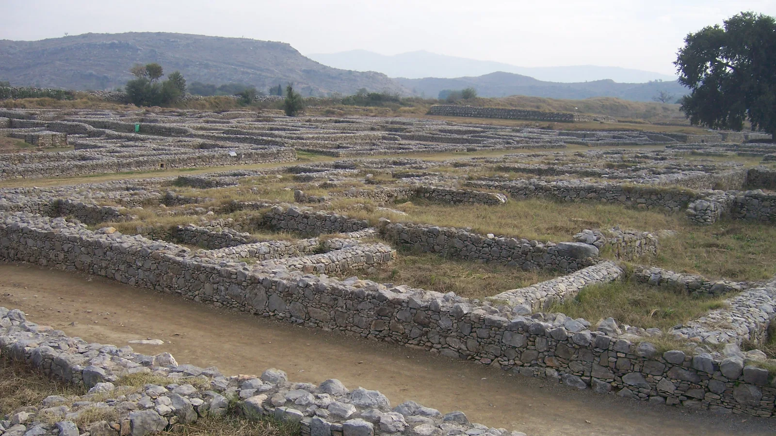
Sirkap’s fortification runs approximately 6,000 yards, its thickness ranging from 15 to 21 feet 6 inches, built of rubble stone that Marshall compared to other structures “of the Greek and Saka-Pahlava epochs” and reinforced with square bastions. Sirsukh’s wall, by contrast, is “not far short of three miles” in circuit, at least 18 feet thick and strengthened with circular bastions spaced 90 feet apart, raised in what Marshall called “large diaper masonry which came into vogue in the early Kushan period.” He corrected Cunningham directly on this point, noting in a footnote that the bastions were round, “not square, or shown by Gen. Cunningham.” Jean Deloche, writing in the Bulletin de l’École française d’Extrême-Orient in 1992, gave Sirkap’s enclosed area as 73 hectares, an irregular polygon with square and pentagonal corner towers, against Sirsukh’s 134 hectares, a parallelogram with semicircular towers.
"The real Akropolis of the ancient city"
Inside Sirkap’s walls, Marshall pointed to an isolated flat-topped hill that he thought was “the real Akropolis of the ancient city of Sirkap,” though he framed the identification as likely rather than proven. His stratigraphy at Sirkap ran, from the surface down, Early Kushan and Parthian buildings, then a layer he assigned “probably to the Scythian epoch,” then two further strata “belonging to the Greek era,” reaching virgin soil at a depth of 14 to 17 feet. Marshall dated the city’s founding to 170-175 BC, when Eucratides took power from Demetrius, but he treated that date as provisional: “our information, as yet, is relatively meagre, since the digging has been chiefly confined to the remains nearest the surface.” Marshall wrote that Apollonius of Tyana “is reputed to have visited Taxila,” probably in AD 44; according to his biographer Philostratus, the reigning king was named Phraotes, and Apollonius found Sirkap “about the same size as Nineveh and fortified like the cities of Greece on a symmetrical plan.”
Sixty-one coins in a Sirkap palace
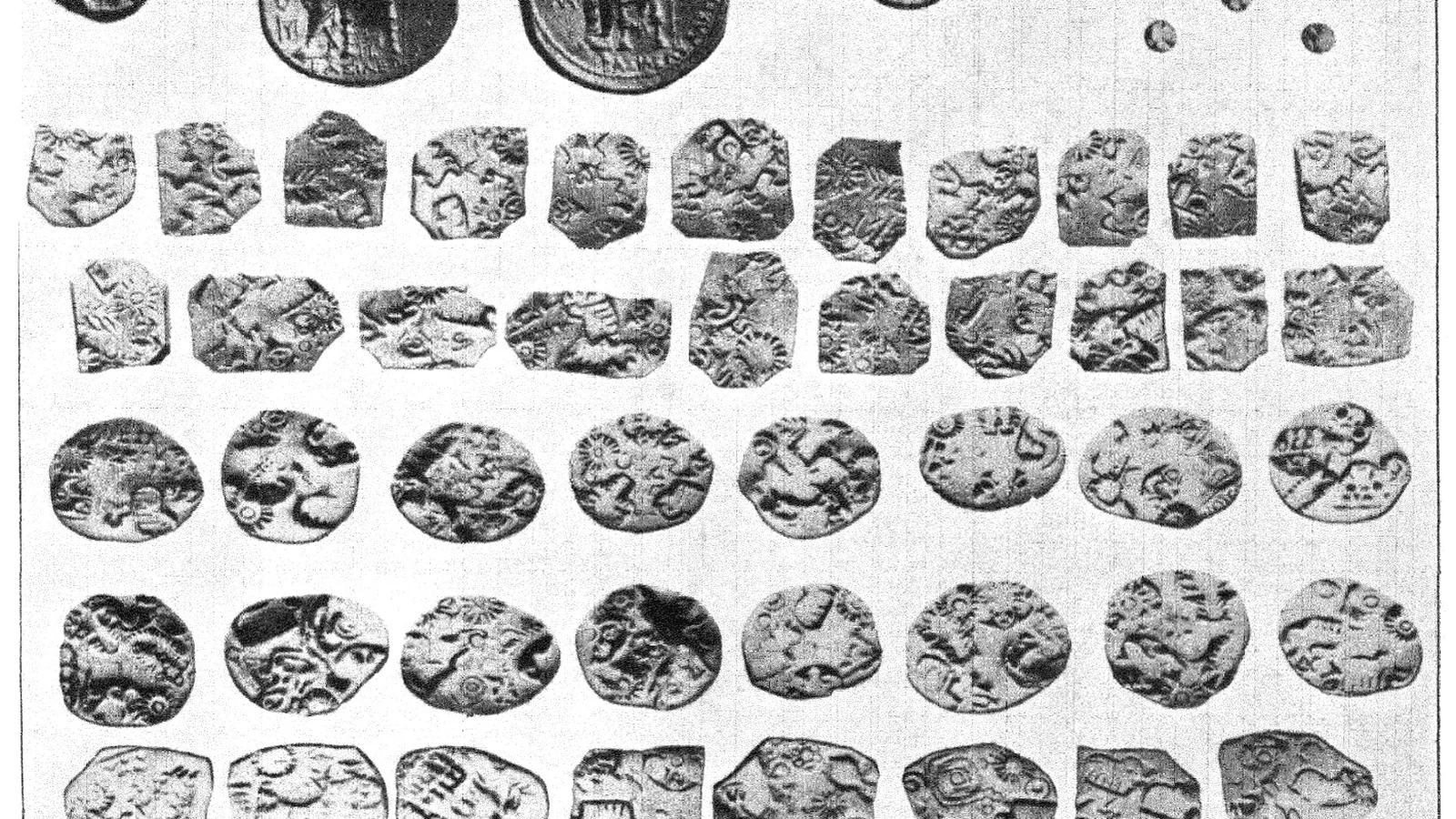
The largest building inside Sirkap’s lower city faced the High Street with a frontage of 352 feet and ran 250 feet from west to east. Its oldest sections, in rough rubble masonry, dated “probably from the Scytho-Parthian era,” with later repairs and additions on top. A. D. H. Bivar’s Encyclopaedia Iranica entry on Gondophares states that after the death of Azes II, “the kingdoms of Taxila and Arachosia were united under one rule by the Parthian Gondophares,” an event Marshall placed in the third decade of the first century AD, after which Gondophares annexed the Kabul valley and drove out the Greek prince Hermaeus. D. W. MacDowall’s Iranica entry on Azes records that his coinage was struck at three mints, Pushkalavati, Taxila and the middle Indus, and that Azes II’s silver underwent “a major debasement” before AD 42. Near the palace, Marshall’s workmen found clay moulds for forging Azes II’s coins, eight whole and twenty broken, which he called “the plant of some forger of the Pahlava epoch.” His 1918 guide records the palace hoard itself as 61 copper coins spanning six Indo-Scythian, Indo-Parthian and early Kushan reigns.

Key facts
- Marshall’s 1918 Guide to Taxila places Bhir Mound, Sirkap and Sirsukh within three and a half miles of each other in one valley.
- Bhir Mound’s plateau measures about 1,210 by 730 yards, rising 60 to 70 feet above the Tamra nala.
- Sirkap’s wall runs about 6,000 yards and 15 to 21 feet 6 inches thick; Sirsukh’s runs nearly three miles and at least 18 feet thick.
- Deloche (1992) gives Sirkap’s enclosed area as 73 hectares and Sirsukh’s as 134 hectares.
- Sirkap’s dig layers run Early Kushan and Parthian, then Scythian, then two Greek strata, to virgin soil at 14 to 17 feet.
- Marshall’s provisional dating placed Sirkap’s founding at 170-175 BC, a date he called meagre pending deeper excavation of the lowest levels.
- A hoard of 61 copper coins of Azes I, Azes II, Aspavarma, Gondophares, Hermaeus and Kadphises I came from Sirkap’s palace.
- Gondophares united Taxila and Arachosia around AD 20-30 and annexed the Kabul valley, driving out Hermaeus, according to Bivar’s Iranica entry.
FAQ
What are the three cities of Taxila?
Bhir Mound, Sirkap and Sirsukh, three separate walled sites within three and a half miles of each other in the same valley, described together in John Marshall's 1918 Guide to Taxila.
When did John Marshall begin excavating Taxila?
In the winter of 1912-13. His own annual reports, cited in the 1918 guide, cover four consecutive winter seasons through 1915-16, following small trial trenches dug by Alexander Cunningham in 1863-64 and 1872-73.
Who was Gondophares and what links him to Sirkap?
Gondophares was the Indo-Parthian king who united Taxila and Arachosia around AD 20-30. Coins struck in his name, alongside those of Azes I, Azes II, Aspavarma, Hermaeus and Kadphises I, formed part of a 61-coin hoard from Sirkap's palace.
Sources
- John Marshall, 'A Guide to Taxila' (Calcutta: Superintendent Government Printing, India, 1918), 1st edition, Cornell University Library copy.
- Willem J. Vogelsang, "Gandhara," Encyclopaedia Iranica, Vol. X, Fasc. 3, pp. 269-270 (published December 15, 2000; last updated March 16, 2016).
- A. D. H. Bivar, "Gondophares," Encyclopaedia Iranica, Vol. XI, Fasc. 2, pp. 135-136 (last updated June 4, 2013).
- D. W. MacDowall, "Azes," Encyclopaedia Iranica, Vol. III, Fasc. 3, p. 257 (published December 15, 1988; last updated June 28, 2016).
- Jean Deloche, "Étude sur les fortifications de l'Inde. I. Les fortifications de l'Inde ancienne," Bulletin de l'École française d'Extrême-Orient 79, no. 1 (1992), pp. 89-131.
Cite this article
- APA
- LETTER. (2026, September 28). Bhir Mound, Sirkap, Sirsukh: John Marshall's three cities of Taxila. Our Earth's History. https://ourearthshistory.com/south-asia/classical/taxila-sirkap-bhir-mound-sirsukh-marshall-1918-guide-three-cities/
- Chicago
- LETTER. “Bhir Mound, Sirkap, Sirsukh: John Marshall's three cities of Taxila.” Our Earth's History, September 28, 2026. https://ourearthshistory.com/south-asia/classical/taxila-sirkap-bhir-mound-sirsukh-marshall-1918-guide-three-cities/.
- MLA
- LETTER. “Bhir Mound, Sirkap, Sirsukh: John Marshall's three cities of Taxila.” Our Earth's History, 28 Sep. 2026, https://ourearthshistory.com/south-asia/classical/taxila-sirkap-bhir-mound-sirsukh-marshall-1918-guide-three-cities/.
Text licensed CC BY-NC-ND 4.0. Found an error? Tell us.