Basalt logs on a reef: Nan Madol, Pohnpei, built from about AD 1180
_4.jpg)
TL;DR — Nan Madol is 92 to 100 islets of stacked basalt columns on a reef off Pohnpei; coral from the first chief’s tomb dates the monuments to AD 1180.
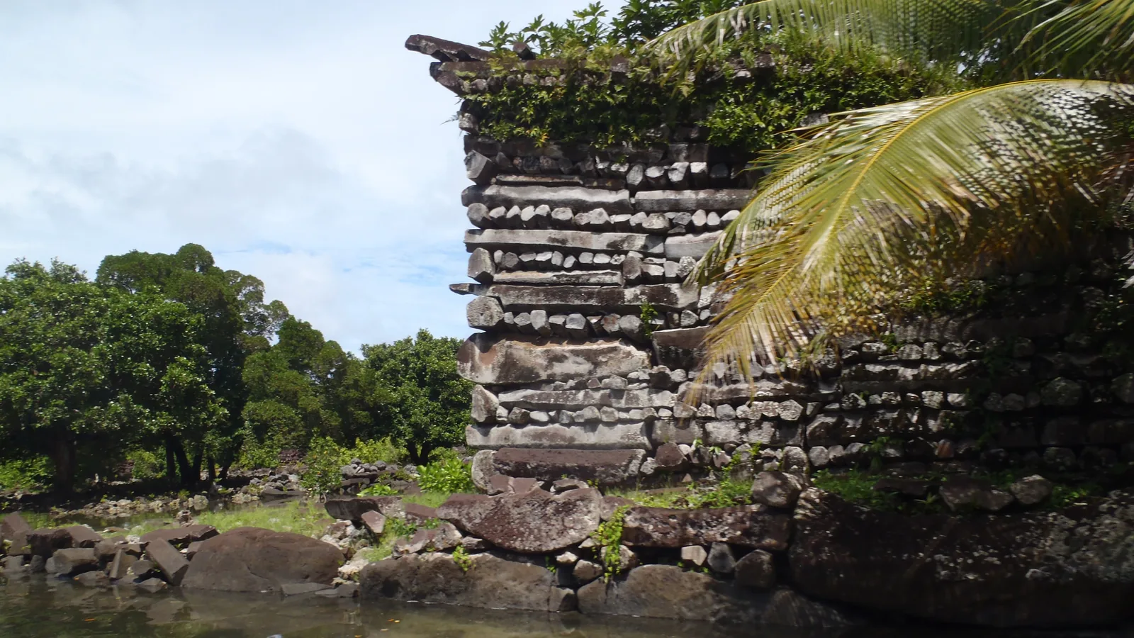
The largest ruin’s outer wall stood “about twenty-five to thirty feet in height,” wrote James F. O’Connell, an American castaway who reached Nan Madol in the early 1830s. His account appeared in Boston in 1836. In 2016 Mark McCoy and colleagues dated coral from “the tomb of the first chief of the entire island” by uranium-thorium decay and placed the start of monument building at AD 1180 to 1200. Nan Madol lies on the reef flat off the south coast of Temwen Island, on the southeast side of Pohnpei, in what is now the Federated States of Micronesia. Its islets, 92 by one count and nearly 100 by another, were built up from coral fill and walled with columns of basalt laid like logs. Oral tradition names the site as the seat of the Saudeleur line, which ruled all Pohnpei until a leader called Isokelekel defeated it and set up the Nahnmwarki chiefs.
Quick facts
- When
- Occupied as a center from about AD 900 · monument building from AD 1180 to 1200 · turtle ceremony about AD 1200 to 1500 or 1600 · Saudeleur rule ended about AD 1500 to 1600 (Athens's back-calculation gives 1628) · O'Connell's visit in the early 1830s · Hambruch's survey March to September 1910
- Where
- The reef flat off the south coast of Temwen Island, on the southeast side of Pohnpei, in what is now the Federated States of Micronesia
- Who
- The Saudeleur rulers and their builders; Isokelekel and the Nahnmwarki in oral tradition; James F. O'Connell (1836), J. S. Kubary (1874), Paul Hambruch (1910); archaeologists J. Stephen Athens, William S. Ayres, Joyce E. Bath, Mark D. McCoy
- Outcome
- About 92 to 100 islets over roughly 80 hectares of reef, walled with columnar basalt from Sokehs Island and Pwusen Malek; construction stopped when the Saudeleur line fell, and the ruins passed to the Nahnmwarki of Madolenihmw
A castaway counts the walls, 1830s
O’Connell came with a companion he called George and a guide who refused to leave the boat. The stones ran “from two to ten feet in length, and from one to eight in breadth,” propped in the gaps with smaller fragments. In the largest compound five or six walls stood parallel inside the outer one, around a square court about forty feet across. Three sides of the outer wall, undermined by the tide, had fallen in places. Inside the innermost wall a piece of wood gave way under him and he dropped into a vault holding one skeleton, which he was later told was a chief of Kitti. The stones, he wrote, required “some mechanical contrivance superior to any thing I met among the natives.”
Coral from a tomb, and a count of islets
McCoy, Helen Alderson, Richard Hemi, Hai Cheng and R. Lawrence Edwards measured the decay of uranium into thorium in coral from the tomb of the island’s first paramount chief and read a start of monument building at AD 1180 to 1200.
In 2012 McCoy and J. Stephen Athens wrote that Nan Madol did not become an elaborate administrative and ceremonial center until about AD 900, that major megalithic building started around AD 1200 to 1300, and that decline followed after about AD 1500 to 1600. William Ayres reported in 1990 that the walled core measured about 1.5 kilometers by 0.5, rose in places to 10 meters above the reef, and held nearly 100 platforms. Joyce Bath and Athens counted 92 islets and about 80 hectares including the canals in the same year; McCoy and Athens gave 93 named islets and 81 hectares in 2012.

Stone from Sokehs Island and Pwusen Malek
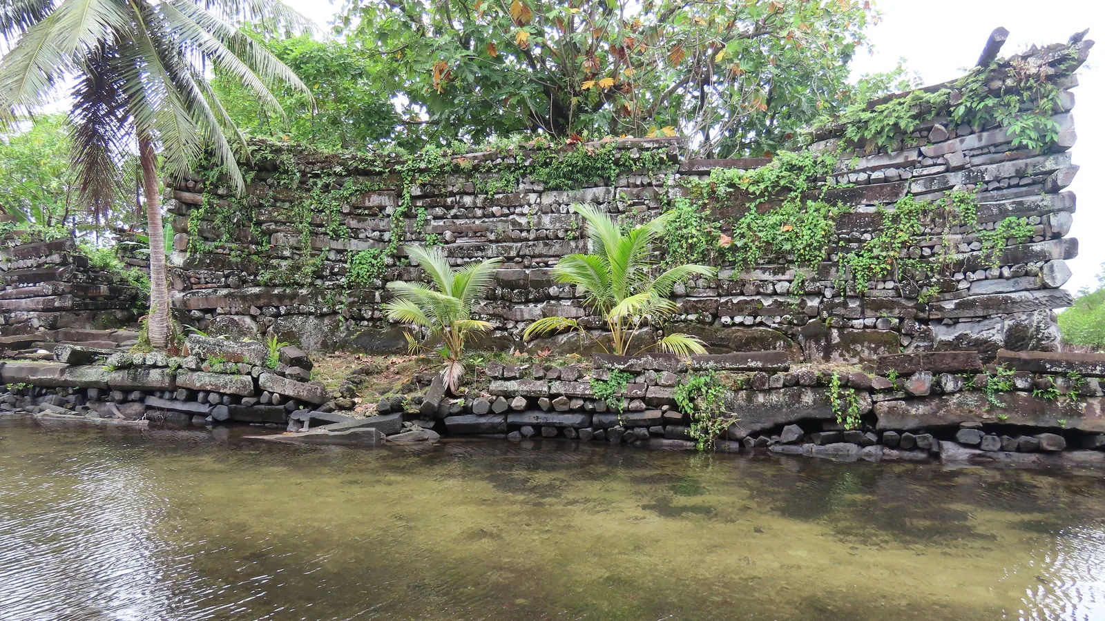
The walls are columnar basalt, natural prisms of volcanic rock stacked in what McCoy and Athens called a header-and-stretcher style on foundations of large boulders. In 2012 they ran X-ray fluorescence on 49 stones from 10 islets and matched most of the columns to basalt from the island’s main shield-building stage, formed 7 to 8 million years ago. Two quarry samples fell in the same chemical group: Sokehs Island and the volcanic plug at Pwusen Malek, both on the northwest of Pohnpei. Boulders came mainly from Temwen Island itself. Nothing tested came from outside Pohnpei.
Bath and Athens wrote in 1990 that no columnar basalt occurs near the site, so columns averaging 1 to 5 tons “had to be transported from the main island, presumably by raft.” Some boulders in the seawall behind the islet of Nandauwas weigh up to 50 tons. The only account of the lifting comes from Pohnpeians who spoke to the German ethnologist Paul Hambruch in 1910: the stones “were brought into their present position by means of the inclined surfaces of tree trunks, especially coconut palms,” with levers and “the tractive force of Hibiscus ropes.”
Kubary's paper, Hambruch's map, and a corner that fell
J. S. Kubary published a paper on the site in 1874, “Die Ruinen von Nanmatal auf der Insel Ponape,” in volume 6 of the Journal des Museum Godeffroy. Hambruch followed for the Hamburg South Seas Expedition and spent March to September 1910 on Pohnpei. He dug on the islet of Pahnkedira, once the Saudeleur residence, and recovered two shell trumpets; his four-page article of 1911 carried a map of the whole complex that archaeologists were still using in 2021, Hilary Howes wrote. His 1936 volume on the ruins, completed after his death by Anneliese Eilers, ran past 400 pages.
In September 1910 a corner of the Pahnkedira wall collapsed. By tradition, master builders from Madolenihmw, Kiti, Sokehs and Katau had each raised one corner, and any district whose corner fell would meet hard times; the one that fell was the Sokehs corner. In October the people of Sokehs rose against German rule and killed the district commissioner, Gustav Boeder. The German reprisal ended with 15 men shot and the rest of the district exiled to Palau.
Isokelekel, the Nahnmwarki, and who keeps the ruins
The end of the Saudeleur line is told in the oral accounts that Hambruch recorded and that Bath and Athens summarized from The Book of Luelen and the manuscript of Masao Hadley. The last Saudeleur captured the god Nan Sapwe; the god escaped to Katau and fathered a son, Isokelekel, who came to Pohnpei with 333 followers and defeated the Saudeleur in battle at Nan Madol. Isokelekel created the office of Nahnmwarki, kept it for himself in Madolenihmw, and conferred the same title on the high chiefs of Kiti and Sokehs, which split the island into three states. Hadley’s account has a typhoon and famine emptying Nan Madol under the fifth Nahnmwarki; Luelen Bernart’s earlier account does not mention an abandonment.
The dates attached to the story are archaeological. Radiocarbon samples from the mound of burned coral left by the turtle ceremony on the islet of Idehd gave a start about AD 1200 and an end in the AD 1500 to 1600 range, so Bath and Athens put the Saudeleur era at 300 to 400 years. The figure of AD 1628 for its end is Athens’s back-calculation from an average reign over the 22 recorded Nahnmwarki of Madolenihmw, not a date in the tradition itself.
In 1910 the ruins had a keeper. Hambruch’s work was arranged by the nahlaimw of Madolenihmw, a priestly title-holder he described as “proprietor of the ruins,” who explained the structures to him in the evenings. Ayres wrote in 1990 that Nan Madol formed an archaeological district of more than 18 square kilometers, and in 2021 Howes wrote that it was Micronesia’s only World Heritage site.
Key facts
- Nan Madol lies on the reef flat off the south coast of Temwen Island, Pohnpei; Bath and Athens counted 92 islets in 1990, McCoy and Athens 93 in 2012, and Ayres “nearly 100” platforms in 1990.
- McCoy, Alderson, Hemi, Cheng and Edwards (2016) dated coral from the first paramount chief’s tomb by uranium-thorium decay to AD 1180 to 1200, the start of monument building.
- McCoy and Athens (2012) placed the site’s rise as a center at about AD 900, major megalithic building at AD 1200 to 1300, and decline after AD 1500 to 1600.
- X-ray fluorescence on 49 stones matched most columns to main-shield basalt, with quarry samples from Sokehs Island and Pwusen Malek; boulders came mostly from Temwen Island.
- Columns average 1 to 5 tons and boulders behind Nandauwas reach 50 tons; Bath and Athens presumed transport by raft, and Hambruch’s informants described tree-trunk ramps, levers and hibiscus rope.
- O’Connell’s 1836 account gave the outer wall of the largest compound as “about twenty-five to thirty feet in height” and recorded a burial vault with one skeleton.
- Kubary published a paper on the ruins in 1874; Hambruch surveyed and dug at Pahnkedira in 1910, and his 1911 map and 1936 volume remained the standard record.
- Oral tradition has Isokelekel, with 333 followers, defeating the last Saudeleur and founding the Nahnmwarki office; AD 1628 for that transition is Athens’s back-calculation, not a traditional date.
FAQ
When was Nan Madol built?
The uranium-thorium coral dates published in 2016 put the start of monument building at AD 1180 to 1200. The site had been a center since about AD 900, and large-scale building ended with the fall of the Saudeleur line about AD 1500 to 1600.
Where did the basalt come from?
From Pohnpei itself. The 2012 X-ray fluorescence study matched most columns to the island's main shield-building basalt, with quarry samples from Sokehs Island and the Pwusen Malek volcanic plug. Boulders came mostly from Temwen Island next to the site.
How many islets are there?
It depends on the count. Bath and Athens gave 92 in 1990, McCoy and Athens 93 named islets in 2012, and Ayres wrote of nearly 100 platforms in 1990. Including the canals the complex covers about 80 to 83 hectares.
Sources
- Quaternary Research 86(3) — Mark D. McCoy, Helen A. Alderson, Richard Hemi, Hai Cheng and R. Lawrence Edwards, "Earliest direct evidence of monument building at the archaeological site of Nan Madol (Pohnpei, Micronesia) identified using 230Th/U coral dating and geochemical sourcing of megalithic architectural stone," 2016, pp. 295–303 (Cambridge Core).
- Journal of Pacific Archaeology 3(1) — Mark D. McCoy and J. Stephen Athens, "Sourcing the Megalithic Stones of Nan Madol: an XRF Study of Architectural Basalt Stone from Pohnpei, Federated States of Micronesia," 2012, pp. 105–115.
- Micronesica Supplement 2 — Joyce E. Bath and J. Stephen Athens, "Prehistoric Social Complexity on Pohnpei: The Saudeleur to Nahnmwarki Transformation," 1990, pp. 275–290.
- Micronesica Supplement 2 — William S. Ayres, "Pohnpei's Position in Eastern Micronesian Prehistory," 1990, pp. 187–212.
- James F. O'Connell, A Residence of Eleven Years in New Holland and the Caroline Islands (Boston: B. B. Mussey, 1836), chapter 15, full text at the Internet Archive.
- ANU Press — Hilary Howes, "Shell trumpets sounding in the stone city: Paul Hambruch and Nan Madol," chapter 16 of Uncovering Pacific Pasts: Histories of Archaeology in Oceania, 2021.
Cite this article
- APA
- Our Earth's History. (2026, September 22). Basalt logs on a reef: Nan Madol, Pohnpei, built from about AD 1180. Our Earth's History. https://ourearthshistory.com/oceania/medieval/nan-madol-pohnpei-basalt-islets/
- Chicago
- Our Earth's History. “Basalt logs on a reef: Nan Madol, Pohnpei, built from about AD 1180.” Our Earth's History, September 22, 2026. https://ourearthshistory.com/oceania/medieval/nan-madol-pohnpei-basalt-islets/.
- MLA
- “Basalt logs on a reef: Nan Madol, Pohnpei, built from about AD 1180.” Our Earth's History, 22 Sep. 2026, https://ourearthshistory.com/oceania/medieval/nan-madol-pohnpei-basalt-islets/.
Text licensed CC BY-NC-ND 4.0. Found an error? Tell us.