Akrotiri: a town under the ash of Thera, and a date no one agrees on
,_Minoan_Civilization,_16th_Century_BC,_National_Archaeological_Museum_of_Athens_(14112030702).jpg)
TL;DR — Akrotiri on Thera was a Cycladic town of three-story houses, paved streets and drains, emptied before the eruption buried it; radiocarbon and Egyptian chronology still disagree on the date.
The main staircase of the West House at Akrotiri has low, wide steps and a large window at each landing, and it climbs to the third floor and the roof. So Clairy Palyvou, the site’s architect, described it in 2005. Akrotiri sits on the south coast of Thera, now Santorini, in the Cyclades, within a short distance of Crete. Spyridon Marinatos began digging there in the summer of 1967 and within ten years had uncovered about 10,000 square meters of a Bronze Age town under volcanic ash. No human skeleton has been found in the town; the people left. When the volcano buried it is not settled: radiocarbon places the eruption in the late 17th or 16th century BC, the chronology built on Egyptian records near 1500 BC.
Quick facts
- When
- 1939 (Marinatos's Antiquity paper) · summer 1967 (excavation begins) · about 1525 BC or 1646 BC (the two ends of the dating dispute, as Palyvou put them in 2005) · 2006, 2014, 2018, 2020 (the main dating papers)
- Where
- Akrotiri, on the south of Thera (Santorini) in the Cyclades, within a short sail of Crete; Therasia, the island across the caldera
- Who
- Spyridon Marinatos, who opened the dig; Christos Doumas, who succeeded him; Clairy Palyvou, the site's architect; Walter Friedrich, Manfred Bietak, Charlotte Pearson and Sturt Manning on the date
- Outcome
- About 10,000 square meters uncovered in ten years, with two- and three-story houses, paved streets, a public drain and painted rooms; no human skeleton in the town; the eruption's date still split between a radiocarbon range and an Egyptian synchronism about a century apart
A question asked in 1939, answered with a spade in 1967
Marinatos published the idea in Antiquity in December 1939 as “The Volcanic Destruction of Minoan Crete.” He argued that the Cretan palaces had been wrecked twice, at the same moment across the island, and that the usual explanation, invaders such as the Achaeans or even the Hyksos, failed on two counts: the decorative arts went on undisturbed, and the second palaces went up at once on the ruins of the first, still unfortified. The Cretans, he wrote, “would not have been so foolish as gratuitously to provide easy loot for fresh invaders.”
Twenty-eight years later he came to test it. Palyvou recorded that he arrived in 1967 “with a vision in his mind and a specific question to answer”: whether the eruption had ended the Minoan world on Crete. The first rooms he cleared near the modern village of Akrotiri belonged to the upper story of a building, which surprised him. He tried tunneling in along a street, then, faced with two- and three-story ruins, followed a ravine where storm water had stripped the ash away.
Streets two meters wide, and a drain under the alley
Palyvou’s measurements show what the ash kept. Main streets were 2.00 to 2.20 meters wide, paved with large flat stones, discarded millstones among them; the excavated stretch of Telchines-Daktylon street runs for more than 120 meters. Under a narrow alley beside the West House runs the public drain, and a large slab covers the pit through which the house’s own drainage joins it.
Walls were stone bound with timber. Vertical wooden reinforcement survives in the buildings Palyvou calls Xeste 2, Xeste 3 and Beta 1, rising two or three stories. She read the diagonal bonding, the pegged beams and the ashlar corners as the work of builders who understood the sideways push of an earthquake; one about 50 years before the eruption, which she labeled the seismic destruction, had forced a rebuilding of the whole settlement.
Painted rooms, and what the paintings show
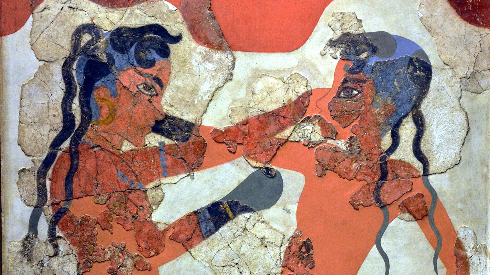
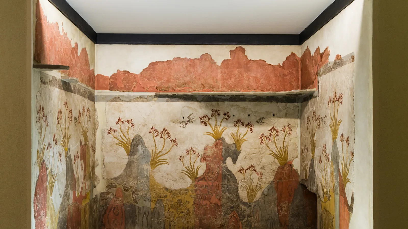
Rooms 4, 4a and 5 of the West House were, in Palyvou’s words, “the most luxurious rooms, decorated with the famous wall paintings of the Fishermen, the Priestess, the Miniature Frieze, and others.” In Beta-South, the first-floor room Beta 1 held the Antelopes and the Boxing Children. In Delta-East, the Spring Fresco covers three of the four walls of Room 2, and the bed that stood there was recovered by pouring plaster of paris into the hollow it left in the ash, the only bed found inside any house.
The National Archaeological Museum in Athens says the painted rooms show “religious scenes and rituals or representations of the natural world.” A second museum page adds that the riverside scenes called Nilotic match the island: a 2014 archaeobotanical study by A. Vlachopoulos and L. Zorzos found that much of Thera before the eruption was streams hidden in reeds, with waterfowl and fish. The painted marsh was a local one.

Beds on the rubble: how the town emptied
An earthquake came first, in Palyvou’s reconstruction. Walls fell and drove people out; a thin layer of ash covered the streets and the debris. Gold and precious metal are rare in the ruins, which she took to mean the residents left in time with their valuables. Then some came back, leveled rubble, blocked doors and windows about to collapse, and brought out food, cooking pots and beds. Three beds stood on the leveled ruins north of Sector Gamma, two side by side and one on top. People were camping in the open when the volcano drove them off for good. Palyvou called the evacuation “timely and effective” and read it as the work of a central authority.
The only human skeleton found in the deposits, as Palyvou reported it, is an old man in a remote rural building on Therasia, the island across the caldera, trapped under his house a few meters from the front door. Where the townspeople went, no excavated evidence says.
Two camps, one olive branch, and a century between them
Palyvou wrote in 2005 that the date had become “a tug of war” between a “low” date around 1525 BC, set by Aegean archaeology in step with Egyptian chronology, and a “high” date of 1646 BC from calibrated radiocarbon.
The radiocarbon side rests partly on a single olive tree. Walter Friedrich and his co-authors reported in Science in April 2006 that a tree “buried alive in life position by the tephra” let them date the eruption to between 1627 and 1600 BC with 95.4 percent probability, “a century earlier than the date derived from traditional Egyptian chronologies.” Manfred Bietak answered in Antiquity in 2014 that olive trees do not form annual rings and that no proof existed the branch was alive at the eruption. Dating Thera by carbon-14, he wrote, “clashes distinctly with historical and archaeological dating.”
Charlotte Pearson and colleagues measured single tree rings from 1700 to 1500 BC and reported in Science Advances in 2018 an offset in the calibration curve that shifted the range for Thera toward the 16th century BC, though any date after about 1510 BC stayed “highly unlikely.” Sturt Manning’s group ran 11 models with the 2020 curve and gave a window of 1619 to 1543 BC, ruling out the conventional low range of 1530 to 1500 BC; final placement, they wrote, depended on whether a small extra regional offset was real.
The size, at least, is measured. Johnston, Sparks, Phillips and Carey estimated in the Journal of the Geological Society in 2014 that 18 to 26 cubic kilometers of dense rock equivalent, the erupted material counted as solid rock, lie in the collapsed caldera, raising the total for the Minoan eruption to 78 to 86 cubic kilometers, “the largest known Holocene eruption.”
Key facts
- Spyridon Marinatos published “The Volcanic Destruction of Minoan Crete” in Antiquity in December 1939 and began excavating Akrotiri in the summer of 1967; ten years of work uncovered about 10,000 square meters (Palyvou 2005).
- Main streets were 2.00 to 2.20 meters wide; the excavated part of Telchines-Daktylon street runs over 120 meters; a public drain passes under the alley west of the West House (Palyvou 2005).
- Timber-reinforced stone walls survive two or three stories high in Xeste 2, Xeste 3 and Beta 1; a separate earthquake about 50 years before the eruption led to a rebuilding of the settlement (Palyvou 2005).
- Palyvou names the West House paintings as the Fishermen, the Priestess and the Miniature Frieze, the Beta 1 paintings as the Antelopes and Boxing Children, and the Delta 2 painting as the Spring Fresco, where a bed was cast in plaster.
- No human skeleton has been found in the town; the one skeleton from the eruption deposits is an old man in a rural building on Therasia (Palyvou 2005).
- Friedrich et al., Science 2006: an olive branch wiggle-matched to 1627–1600 BC at 95.4 percent; Bietak, Antiquity 2014: olive trees lack annual rings and the branch’s outer wood is missing.
- Pearson et al. 2018 shifted the radiocarbon range toward the 16th century BC; Manning et al. 2020 gave 1619–1543 BC and excluded 1530–1500 BC.
- Johnston et al. 2014: 78–86 cubic kilometers dense rock equivalent, “the largest known Holocene eruption.”
FAQ
When did the Thera eruption happen?
The published answers differ by about a century. Radiocarbon studies (Friedrich 2006, Pearson 2018, Manning 2020) put it between the late 17th and mid 16th century BC; the chronology tied to Egyptian records, defended by Manfred Bietak, puts it near 1500 BC.
Were bodies found at Akrotiri?
None in the town. Clairy Palyvou reported one skeleton from the eruption deposits, an old man in a rural building on the neighboring island of Therasia. Beds and cooking pots left on the rubble show people camped outside after an earthquake before leaving for good.
Who dug Akrotiri?
Spyridon Marinatos opened the excavation in 1967 to test his 1939 theory that the eruption had destroyed Minoan Crete; Christos Doumas directed the work after him. Earlier soundings had been made by French visitors in the 19th century.
Sources
- Spyridon Marinatos, "The Volcanic Destruction of Minoan Crete," Antiquity 13(52), December 1939, pp. 425–439 (Cambridge Core, extract and notes).
- Clairy Palyvou, Akrotiri Thera: An Architecture of Affluence, 3,500 Years Old (INSTAP Academic Press, Philadelphia, 2005), full text on the Internet Archive.
- Walter L. Friedrich et al., "Santorini eruption radiocarbon dated to 1627–1600 B.C.," Science 312(5773), April 28, 2006, p. 548; abstract via PubMed.
- Manfred Bietak, "Radiocarbon and the date of the Thera eruption," Antiquity 88(339), March 2014, pp. 277–282 (Cambridge Core, abstract).
- Charlotte L. Pearson et al., "Annual radiocarbon record indicates 16th century BCE date for the Thera eruption," Science Advances 4(8), August 3, 2018, via PubMed Central.
- Sturt W. Manning et al., "Radiocarbon offsets and old world chronology as relevant to Mesopotamia, Egypt, Anatolia and Thera (Santorini)," Scientific Reports 10, 13785, August 17, 2020.
- E. N. Johnston, R. S. J. Sparks, J. C. Phillips and S. Carey, "Revised estimates for the volume of the Late Bronze Age Minoan eruption, Santorini, Greece," Journal of the Geological Society 171(4), 2014; abstract at the University of Rhode Island DigitalCommons.
- National Archaeological Museum, Athens — "Collection of Antiquities of Thera."
- National Archaeological Museum, Athens — Monthly artefact, the inlaid dagger from Mycenae and the Aegean "Nilotic" landscapes, citing Vlachopoulos and Zorzos (2014).
Cite this article
- APA
- Our Earth's History. (2026, September 21). Akrotiri: a town under the ash of Thera, and a date no one agrees on. Our Earth's History. https://ourearthshistory.com/europe/ancient/akrotiri-thera-eruption-town-under-ash/
- Chicago
- Our Earth's History. “Akrotiri: a town under the ash of Thera, and a date no one agrees on.” Our Earth's History, September 21, 2026. https://ourearthshistory.com/europe/ancient/akrotiri-thera-eruption-town-under-ash/.
- MLA
- “Akrotiri: a town under the ash of Thera, and a date no one agrees on.” Our Earth's History, 21 Sep. 2026, https://ourearthshistory.com/europe/ancient/akrotiri-thera-eruption-town-under-ash/.
Text licensed CC BY-NC-ND 4.0. Found an error? Tell us.