Nearly 2 million cubic yards by the basketful: Poverty Point, 1700 BC

TL;DR — Hunter-gatherers at Poverty Point, Louisiana, moved nearly 2 million cubic yards of earth between 1700 and 1100 BC; Mound A alone took as many as 15.5 million basket loads.
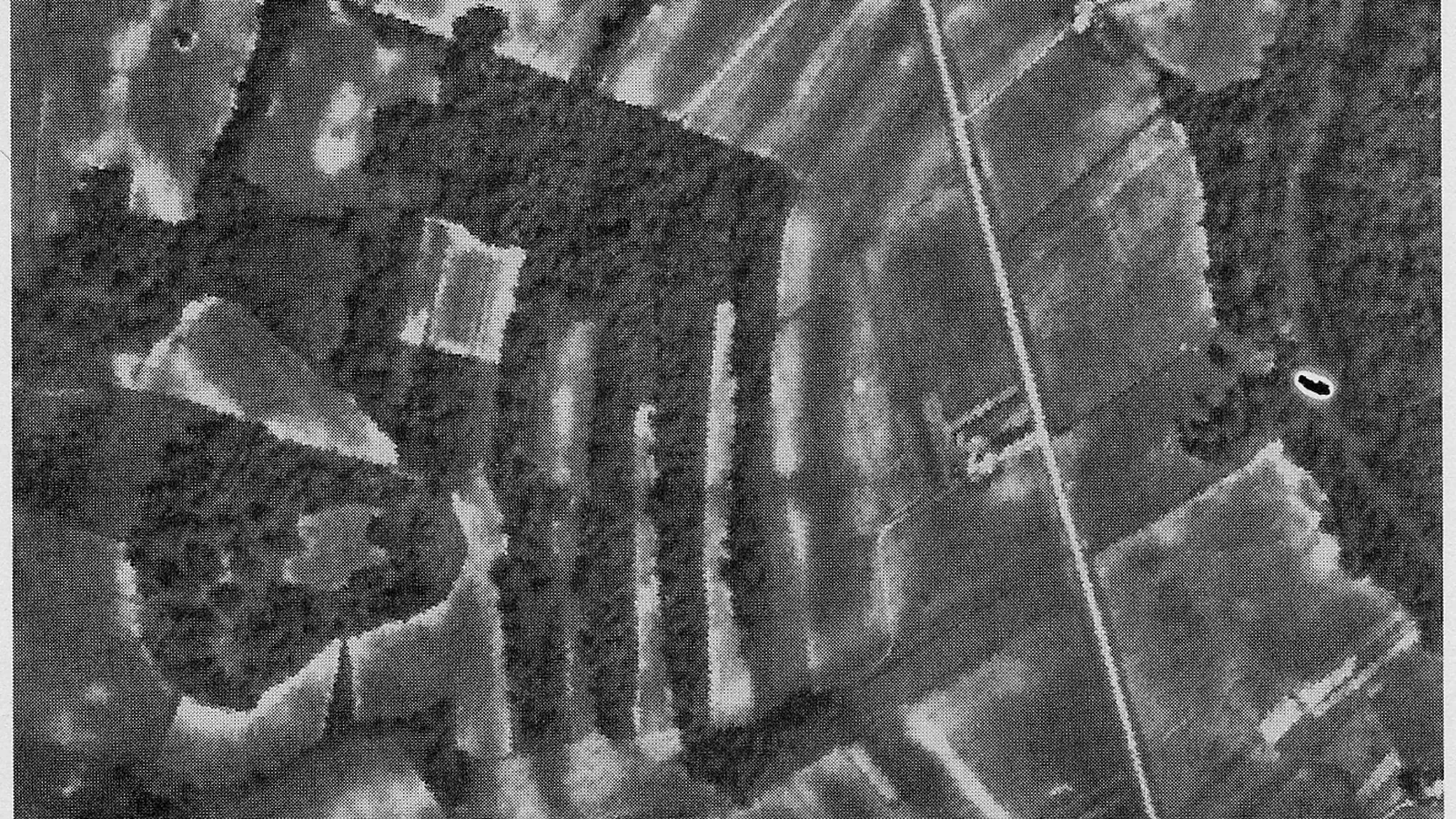
“[P]eople moved nearly 2 million cubic yards of earth to make the site,” reads the education booklet that the Louisiana Division of Archaeology published in 2014 on Poverty Point, an earthwork complex on Bayou Maçon in northeast Louisiana built by hunter-gatherers who grew no crops. They raised six concentric C-shaped ridges whose outermost ring, the Louisiana Office of State Parks states, “measures nearly three-quarters of a mile” in diameter, and a mound 72 feet tall. The booklet dates the first mounds to around 1700 BC and the last of the Late Archaic series about 600 years later, “nearly 25 generations.” The site became a National Historic Landmark in 1962 and a World Heritage property on June 22, 2014. No burial of the builders has been found there.
Quick facts
- When
- Around 1700 BC (first mounds, Mound B and Mound E) · around 1300–1350 BC (Mound A) · 1100 BC (end of the Late Archaic earthworks) · around AD 700 (Mound D, by later people) · 1962 (National Historic Landmark) · June 22, 2014 (World Heritage List)
- Where
- Poverty Point, on Bayou Maçon in northeast Louisiana, in what is now the United States
- Who
- Late Archaic hunter-gatherers who grew no crops; geoarchaeologists Anthony L. Ortmann and Tristram R. Kidder (2013 study of Mound A); the Louisiana Division of Archaeology and Office of State Parks; the U.S. National Park Service
- Outcome
- Six concentric C-shaped ridges, a 43-acre plaza and a 72-foot mound built from nearly 2 million cubic yards of earth, with no burials of the builders found; inscribed as the 1,001st World Heritage property on June 22, 2014
Six ridges, four aisles and a plaza of 43 acres
The State Parks description is short: “The central construction consists of six rows of concentric ridges, parts of which were as high as five feet. The ridges form a semi-ellipse or C-shape, divided into sections by at least four aisles.” The Division of Archaeology booklet gives the highest ridge as “over 6 feet tall.” Between the ridges run low ditches called swales, 65 to 100 feet wide; outside the southwestern section a causeway about 295 feet long and almost 50 feet wide crosses a shallow depression. The ridges enclose a plaza of 43 acres, and under it are holes where hundreds of wooden posts once stood in circles up to 213 feet in diameter.
State Parks counts “53 million cubic feet of soil” and says that laborers carried the dirt “in roughly 50-pound basket loads.” The Division of Archaeology counts nearly 2 million cubic yards and converts it for schoolchildren: at 52 cubic yards per dump truck, “about 38,462 dump truck loads of dirt.”
Mound A and a platform raised in a single episode
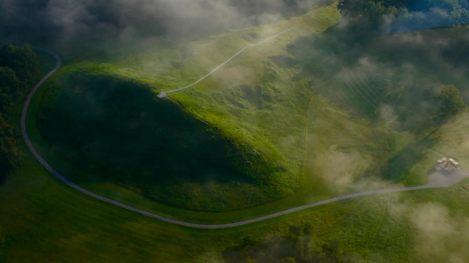
The booklet gives Mound A as 72 feet tall, 710 feet long and 660 feet wide, and says that making it “would have taken as many as 15.5 million basket loads of earth.” Builders made it in three sections, the cone, the platform and a ramp linking the two, and after the first two, the booklet says, “builders took a long break before making the ramp.” The booklet gives the mound’s date twice, as around 1350 BC on one page and around 1300 BC on another.
The platform is the part that has drawn the argument. “Some archaeologists think that people built this section in less than 90 days!” the booklet says, adding that it was made “in a single episode, mixing different colored soils found around the site.” Anthony L. Ortmann and Tristram R. Kidder published a study of the mound’s stratigraphy in Geoarchaeology in 2013. Their abstract describes “the massive size and rapid construction of Mound A,” reports “no erosion events, natural episodes of soil formation, or cultural stages,” and concludes that the mound “was constructed by a large labor force over a short period of time.” The 90-day figure does not appear in that abstract. Ortmann and Kidder also wrote that Mound A “challenges” the reading of hunter-gatherer monuments as a sign of “social and political inequality.”
Mound B, a cone 21 feet tall, was started around 1700 BC; Mound E, 13 feet tall, dates to about the same time. Mound C is the only mound built in the plaza during Poverty Point times, and Mound F, nearly five feet tall, was the last of the Late Archaic series. Mound D was raised around AD 700 by Late Woodland people.
_at_Poverty_Point.jpg)
Fish bones, fired clay and no graves
The soils at Poverty Point preserve bone poorly, but the booklet reports more fish bones at the site than any other kind. Persimmons, pawpaws, muscadine grapes, pecans and black walnuts were gathered; no cultivated plant has been found. The most common artifact of all is a cooking ball. “Poverty Point Objects (or PPOs) are fired ceramics that were used in place of cooking stones,” the booklet explains; people shaped them from the fine soil of the site in four forms, “biconical, cylindrical grooved, cross grooved, and melon shaped,” and heated them in a fire pit to roast or steam food.
On burials the booklet’s answer is flat: “To date, archaeologists have not found any American Indian burials at the site. The only known graves on the site are those of historic settlers and slaves.” It adds that “there is no evidence that any persons or families were privileged.”
"There were no rocks near the site"
The clay cooking balls exist because of what the booklet calls “the only major drawback to living at Poverty Point”: “there were no rocks near the site.” The Division of Archaeology counts “over 70 tons of rocks and minerals” brought “from as far north as Iowa and as far east as the Appalachian Mountains”; the Louisiana Office of Tourism, on its Poverty Point site, counts “more than 78 tons” carried “from as far as 800 miles away.” Soapstone bowls arrived finished from quarries in what is today Georgia and Alabama, since, as the booklet puts it, “It is much more efficient to transport a hollowed-out bowl than a block of stone.”
Copper came too. A 2018 paper in the Proceedings of the National Academy of Sciences by Matthew C. Sanger and colleagues cited a copper plummet from Poverty Point first reported by R. E. Bell in American Antiquity in 1956 and wrote that “The presence of copper at Poverty Point provides further evidence that the site was a major trade center.” Fewer than 30 of the red jasper “pot-bellied” owl pendants have been found, most of them at other sites, some as far away as eastern Florida.
June 22, 2014: the 1,001st property on the World Heritage List
The U.S. Department of the Interior designated Poverty Point a National Historic Landmark in 1962. On June 22, 2014, the National Park Service records, “at the 38th Session of the World Heritage Committee in Doha, Qatar, Poverty Point State Historic Site was inscribed as the 1,001st property on the World Heritage List.” The Park Service has no facilities there; the State of Louisiana operates the site.
The Division of Archaeology’s booklet, published the same year as the inscription, takes up the question of purpose in its frequently asked questions. “Why did American Indians build the mounds at Poverty Point?” the second question reads, and the answer begins: “We do not know.”
Key facts
- The Louisiana Division of Archaeology dates Poverty Point’s earthworks to between 1700 BC and 1100 BC, “about 600 years” and “nearly 25 generations” (2014 booklet).
- The Office of State Parks describes six concentric C-shaped ridges “as high as five feet,” divided by at least four aisles, with an outermost diameter of “nearly three-quarters of a mile”; the Division of Archaeology gives the highest ridge as “over 6 feet tall.”
- The Division of Archaeology counts “nearly 2 million cubic yards of earth” moved; State Parks counts “53 million cubic feet of soil” carried in “roughly 50-pound basket loads.”
- Mound A is 72 feet tall, 710 feet long and 660 feet wide, and would have taken “as many as 15.5 million basket loads of earth”; the booklet dates it to around 1300–1350 BC.
- The booklet says “Some archaeologists think” the platform section of Mound A was built “in less than 90 days”; Ortmann and Kidder’s 2013 abstract in Geoarchaeology describes “rapid construction” with no erosion or soil formation between layers.
- No American Indian burials have been found at the site; the only known graves are those of historic settlers and slaves (Division of Archaeology).
- Stone came from as far as Iowa and the Appalachians: “over 70 tons” (Division of Archaeology) or “more than 78 tons” from “as far as 800 miles away” (Office of Tourism); copper is reported in a 2018 PNAS paper by Sanger and colleagues.
- Poverty Point became a National Historic Landmark in 1962 and, on June 22, 2014, in Doha, the 1,001st property on the World Heritage List (National Park Service).
FAQ
How much earth was moved to build Poverty Point?
The Louisiana Division of Archaeology gives "nearly 2 million cubic yards," or about 38,462 large dump-truck loads. The Office of State Parks gives the same volume as 53 million cubic feet, carried in basket loads of roughly 50 pounds.
How long did it take to build Mound A at Poverty Point?
The state's 2014 booklet says "Some archaeologists think" the platform section was built in less than 90 days, in a single episode. The 2013 Geoarchaeology study by Anthony L. Ortmann and Tristram R. Kidder describes the mound's "rapid construction" by "a large labor force over a short period of time," with no erosion or soil formation between the layers.
When did Poverty Point become a World Heritage Site?
On June 22, 2014, at the 38th Session of the World Heritage Committee in Doha, Qatar, according to the U.S. National Park Service. It was the 1,001st property inscribed on the list. The site had been a National Historic Landmark since 1962.
Sources
- Louisiana Division of Archaeology, "Poverty Point," Discover Archaeology education series, PDF booklet of 32 pages (content adviser Diana Greenlee; © 2014 Louisiana Division of Archaeology). Read via Wayback Machine snapshot (live site blocks automated access).
- Louisiana Office of State Parks, Department of Culture, Recreation and Tourism, "Poverty Point World Heritage Site" (site description page, 2020). Read via Wayback Machine snapshot (live site blocks automated access).
- Louisiana Office of Tourism, povertypoint.us, "Welcome to Poverty Point World Heritage Site" (main page). Read via Wayback Machine snapshot (live site blocks automated access).
- Louisiana Office of Tourism, povertypoint.us, "History & Artifacts of Poverty Point." Read via Wayback Machine snapshot (live site blocks automated access).
- Anthony L. Ortmann and Tristram R. Kidder, "Building Mound A at Poverty Point, Louisiana: Monumental Public Architecture, Ritual Practice, and Implications for Hunter-Gatherer Complexity," Geoarchaeology 28, no. 1 (2013): 66–86, DOI 10.1002/gea.21430; abstract and bibliographic record via the Crossref API.
- Matthew C. Sanger et al., "Early metal use and crematory practices in the American Southeast," Proceedings of the National Academy of Sciences 115 (2018), open-access text at PubMed Central (PMC6099914).
- U.S. National Park Service, "Basic Information," Poverty Point National Monument (page last updated March 10, 2016).
- U.S. National Park Service, Poverty Point National Monument, main page (last updated April 4, 2016) and "Frequently Asked Questions" (last updated April 14, 2015).
Cite this article
- APA
- Our Earth's History. (2026, September 22). Nearly 2 million cubic yards by the basketful: Poverty Point, 1700 BC. Our Earth's History. https://ourearthshistory.com/americas/ancient/poverty-point-louisiana-mound-a-earthworks-1700-bc/
- Chicago
- Our Earth's History. “Nearly 2 million cubic yards by the basketful: Poverty Point, 1700 BC.” Our Earth's History, September 22, 2026. https://ourearthshistory.com/americas/ancient/poverty-point-louisiana-mound-a-earthworks-1700-bc/.
- MLA
- “Nearly 2 million cubic yards by the basketful: Poverty Point, 1700 BC.” Our Earth's History, 22 Sep. 2026, https://ourearthshistory.com/americas/ancient/poverty-point-louisiana-mound-a-earthworks-1700-bc/.
Text licensed CC BY-NC-ND 4.0. Found an error? Tell us.