Ships or shadufs: Lothal's 219-meter brick basin in Gujarat

TL;DR — S. R. Rao called Lothal’s brick basin the world’s earliest dock; Leshnik’s 1968 measurements pointed to a water tank, and the question stayed open.
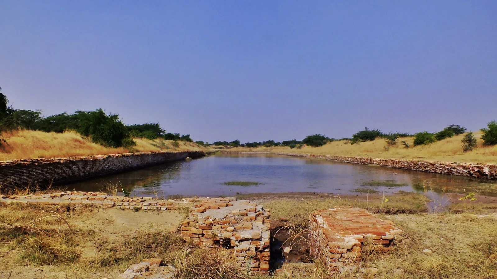
In a paper for the International Congress of Orientalists in New Delhi, listed under 1964, S. R. Rao described his find at Lothal in Gujarat as “an artificial brick structure measuring 219 x 37 m. to receive ships and handle cargo in their busy port.” Rao, the site’s excavator, called it the earliest dock in the world. Umakant P. Shah had already read the basin as a reservoir for drinking water, and in 1968 Lawrence S. Leshnik used the published measurements to argue that ships could not have entered it and that it stored water for irrigation. Rao’s final report appeared in 1979 and 1985. A 2004 study in Antiquity found that the town grew on a tidal salt marsh later left dry by a falling sea. Government of India releases on a maritime heritage complex beside the site repeat Rao’s phrase.
Quick facts
- When
- 1955 to 1962 (excavation) · 1960/61 and 1964 (Rao's "oldest" and "earliest" dock phrases) · 1968 (Leshnik's critique) · 1979 and 1985 (final report) · 2004 (Antiquity study) · June 16, 2021, October 18, 2022 and October 9, 2024 (government releases on the heritage complex)
- Where
- Lothal, between the Bhogava and Sabarmati rivers near the head of the Gulf of Khambhat, Gujarat, India
- Who
- S. R. Rao, excavator; Umakant P. Shah; Lawrence S. Leshnik; Gregory L. Possehl; Shereen Ratnagar; A. S. Khadkikar, C. Rajshekhar and K. P. N. Kumaran; the Government of India
- Outcome
- Rao's dock reading and the reservoir or irrigation-tank reading both remain in print, and the Government of India is building a National Maritime Heritage Complex beside the site
Rao's dock, in his own words
Lothal lies on a plain between the Bhogava and Sabarmati rivers, at the head of the Gulf of Khambhat. Leshnik placed it near Saragwala village, about fifty miles southwest of Ahmedabad and some twelve miles from the coast. Rao wrote that his survey of the Gujarat coastline in 1954-60 had located several Harappan settlements at river mouths, and that “The most important among them is Lothal.” Shereen Ratnagar, in a review for the Oxford Research Encyclopaedia, dates the excavation to 1955-1962 and describes the plan: a town on the west, the “dock basin” on the east, and a “wharf” between them.
Rao’s paper dated Lothal’s Period A, the mature Harappan phase, to 2450-1900 BC. He built his case on trade: copper ingots, a Persian Gulf seal and objects that resembled finds from Susa in the Louvre. “The constructional and other details of the dock at Lothal which happens to be the earliest in the world have been mentioned elsewhere,” he wrote. Leshnik quoted Rao as having presented “conclusive proof” that ships were berthed there. A bibliography in the same reprint volume lists a piece by Rao in the 1960/61 annual of The Onlooker under the title “The oldest dock in the world.”
1962 to 1965: the ships' route changes twice
Leshnik traced three versions of how ships reached the basin. In 1962 Rao had them sluiced in at high tide from the gulf through a gap in the eastern wall, probably by a creek east of the basin, which meant a 90-degree turn to berth. An Archaeological Survey of India report of 1963 moved the approach to the river on the west, by a navigation canal skirting the northern edge of the town.
In a 1965 article in Expedition, Rao divided the dock’s life into two stages. First, ships entered through a fifty-five-foot gap in the northern wall, which Leshnik said had not been reported before. The basin was designed, Rao wrote, “to sluice ships 18-20 meters long and 4-6 meters wide.” After an “unprecedented flood” shifted the river east, a new inlet was cut into the eastern wall, and “In Stage II however, only flat bottoms could enter.” Leshnik set this against a survey report of 1962, in which entry through the eastern inlet had been “established beyond doubt.” Rao, he wrote, “does not tell us why he changed his mind.” Leshnik also tried to find the northern inlet on the site and failed.
"Patently inadequate clearance": Leshnik's measurements
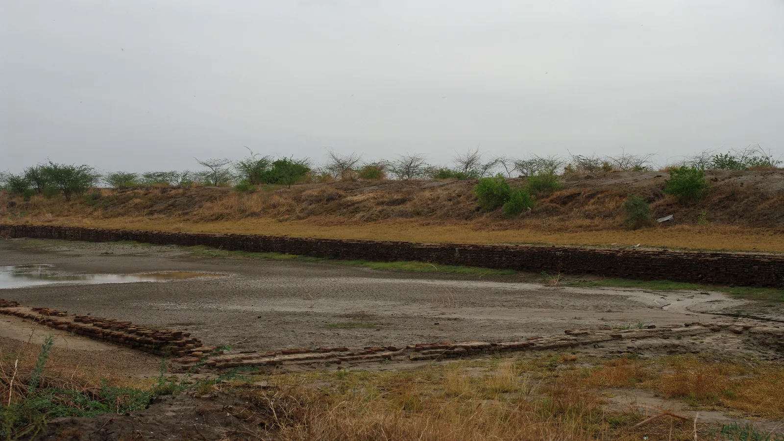
Leshnik took his figures from the survey’s review for 1958-59. The long sides ran 710 feet, the southern end 116 feet and the northern end 124 feet, or about 216 by 35 to 38 meters. A burnt-brick wall four courses wide lined all four sides to a greatest surviving depth of fourteen feet, about 4.3 meters. The walls were vertical, with no steps.
The eastern inlet came first. With “hardly three feet” between the sill of the gap and the rim of the walls beside it, Leshnik wrote, there was “patently inadequate clearance for even a small fishing vessel” of the kind then working the coast, boats of about 100 tons that drew some four feet. The jambs ended in uneven steps, so the opening looked like “a chance breach effected by brick robbers,” and he found no fitting for a sluice gate 23 feet wide.
The channel came next. A brick conduit about a yard wide left the southern wall and had been called a spill channel. Its steps and its gradient ran toward the basin. “With the conduit serving as an inlet, the basin cannot have been a dock,” Leshnik wrote.
Then the stones. Seven pierced “anchor” stones were found, five in the basin area. The largest was about sixteen inches across, “only doubtfully heavy enough to have served as an anchor by itself.” Leshnik proposed that they weighted the arms of shadufs, the pole-and-bucket water lifts still used near Lothal, and noted that a shaduf seldom lifts water more than fifteen feet, close to the basin’s depth. Rao’s mooring-post holes along the rim could have held shaduf uprights. Shah had proposed drinking water. Leshnik went further: “I believe its primary purpose was to store water for irrigation.”
.jpg)
Sealings, satellite images and a late report
Rao’s final report, Lothal 1955-1962: A Harappan Port Town, came out in two volumes, in 1979 and 1985. Ratnagar suspects Rao spent the delay answering objections and finds the text “replete with confusing paragraphs and self-contradictions.” In 1979 he gave the northern inlet as two and a half feet above the floor in the first stage and the eastern inlet as 23 feet wide. “Dimensions of features he describes in his publications vary,” Ratnagar writes, and he ignored the question of shaduf weights.
Gregory L. Possehl, who edited the volume that reprinted Leshnik, wrote in 1976 that “neither of these alternatives, the tank versus the dockyard, is fully convincing.” He had seen the stones displayed on the site. Their holes, two or three inches across, suited a rope but not a shaduf arm, and seasonal floods and shallow groundwater left little need for an irrigation tank.
Ratnagar compared the basin, no more than 3 meters deep, with Dholavira’s stone Eastern Reservoir, which has flights of steps and goes down 7 to 10 meters. She also pointed to the warehouse, where some 90 to 100 clay sealings from tied packages turned up, and to Rao’s term for Lothal, a “clearing house.”
In 2004 A. S. Khadkikar, C. Rajshekhar and K. P. N. Kumaran used multispectral satellite images and environmental analysis. Their abstract reports a tidal palaeochannel west of the town and a former estuary to the east, and states that “Lothal developed over a tidal salt marsh and was subsequently left high and dry as the sea level dropped.” The abstract does not discuss the basin. Near its close Ratnagar’s paper states that “The question of Lothal’s place in the economy is still open,” and adds that “the seals and sealings indicate that the site may have functioned as a port.”
From The Onlooker to the Union Cabinet
Rao’s phrase outlived the argument about the basin. On June 16, 2021, the Press Information Bureau announced an agreement between the Ministry of Culture and the Ministry of Ports, Shipping and Waterways for a National Maritime Heritage Complex on about 400 acres near the site, some 80 kilometers from Ahmedabad. Its “unique feature” would be a recreation of ancient Lothal, a city “dating to 2400 BC.”
On October 18, 2022, a release on the prime minister’s review of the project gave its cost as Rs 3,500 crore and stated: “Archaeological excavations have discovered the oldest man-made dockyard, over 5000 years old, in Lothal.” The same release dates the city to 2400 BC.
On October 9, 2024, the Union Cabinet approved the complex in two phases, with a master plan by the firm of Hafeez Contractor and Phase 1A built by Tata Projects. That release reported Phase 1A at “more than 60% physical progress,” planned to be completed by 2025.
Key facts
- S. R. Rao described the Lothal basin as a brick structure “219 x 37 m.” built “to receive ships and handle cargo,” in a congress paper listed under 1964 (Possehl, ed., 1979).
- Rao dated Lothal’s mature Harappan Period A to 2450-1900 BC.
- Rao’s phrasing of “the dock at Lothal which happens to be the earliest in the world” appears in that paper; a 1960/61 piece of his in The Onlooker was titled “The oldest dock in the world.”
- Rao placed the ships’ entrance first on the east (1962), then via a northern canal (1963), then in two stages with a fifty-five-foot northern gap (1965), as Leshnik traced it.
- Leshnik gave the basin as 710 feet long, 116 and 124 feet across the ends, and up to fourteen feet deep, and the eastern sill as “hardly three feet” below the rim.
- Leshnik read the southern brick channel, which slopes toward the basin, as an inlet, and the pierced stones, the largest about sixteen inches across, as shaduf counterweights.
- Khadkikar, Rajshekhar and Kumaran (Antiquity, 2004) wrote that Lothal “developed over a tidal salt marsh” and was left “high and dry as the sea level dropped.”
- A Press Information Bureau release of October 18, 2022 called Lothal’s dockyard “the oldest man-made dockyard, over 5000 years old.”
FAQ
Was the Lothal dockyard really a dock?
Its excavator, S. R. Rao, said it was, and published its dimensions as 219 by 37 meters. Umakant Shah read it as a drinking-water reservoir and Lawrence Leshnik in 1968 as an irrigation tank. Gregory Possehl found neither reading fully convincing, and Shereen Ratnagar's review calls Lothal's place in the economy still open.
Who first called Lothal the oldest dock in the world?
Rao did. A bibliography reprinted in 1979 lists his 1960/61 article "The oldest dock in the world" in The Onlooker, and his congress paper called the dock "the earliest in the world." A Government of India release of October 18, 2022 used "the oldest man-made dockyard."
What are the anchor stones found at Lothal?
Pierced stones, seven in all, five of them from the basin area. Rao treated them as anchors. Leshnik noted that the largest was about sixteen inches across and proposed that they were counterweights for shadufs; Possehl, who saw them on site, thought their holes too small for that.
Sources
- Gregory L. Possehl, ed., Ancient Cities of the Indus (New Delhi: Vikas Publishing House, 1979), reprinting S. R. Rao, "Contacts between Lothal and Susa" (26th International Congress of Orientalists, New Delhi), Lawrence S. Leshnik, "The Harappan 'Port' at Lothal: Another View" (American Anthropologist 70, no. 5, 1968), and Possehl, "Lothal: A Gateway Settlement of the Harappan Civilization" (1976); Internet Archive, Digital Library of India copy.
- Shereen Ratnagar, "The Story of an Ancient Dock: Lothal in the History of the Indian Ocean" (revised manuscript for the Oxford Research Encyclopaedia), hosted by Harappa.com.
- A. S. Khadkikar, C. Rajshekhar and K. P. N. Kumaran, "Palaeogeography around the Harappan port of Lothal, Gujarat, western India," Antiquity 78, no. 302 (December 2004): 896-903 (abstract), Cambridge University Press.
- Press Information Bureau, Government of India, "Ministry of Culture and Ministry of Ports, Shipping and Waterways sign an MoU for Cooperation in Development of National Maritime Heritage Complex (NMHC) at Lothal, Gujarat" (June 16, 2021).
- Press Information Bureau, Government of India, "Prime Minister Shri Narendra Modi reviews the progress of National Maritime Heritage Complex at Lothal, Gujarat" (October 18, 2022).
- Press Information Bureau, Government of India, "Cabinet approves development of National Maritime Heritage Complex (NMHC), Lothal, Gujarat" (October 9, 2024).
Cite this article
- APA
- LETTER. (2026, September 28). Ships or shadufs: Lothal's 219-meter brick basin in Gujarat. Our Earth's History. https://ourearthshistory.com/south-asia/ancient/lothal-dock-or-reservoir-rao-leshnik-219-meter-basin/
- Chicago
- LETTER. “Ships or shadufs: Lothal's 219-meter brick basin in Gujarat.” Our Earth's History, September 28, 2026. https://ourearthshistory.com/south-asia/ancient/lothal-dock-or-reservoir-rao-leshnik-219-meter-basin/.
- MLA
- LETTER. “Ships or shadufs: Lothal's 219-meter brick basin in Gujarat.” Our Earth's History, 28 Sep. 2026, https://ourearthshistory.com/south-asia/ancient/lothal-dock-or-reservoir-rao-leshnik-219-meter-basin/.
Text licensed CC BY-NC-ND 4.0. Found an error? Tell us.